Alaska Climate Summary: May and Spring 2023
Wet was the Word
May 2023 overall saw temperatures average close to normal while most areas were wetter than normal. The May sea ice and wildfire update is here. In May much of the “action” was at the shorter duration extreme event level, with locally severe ice jam/snow melt flooding, locally extreme precipitation and late season snow. Spring 2023 was very active and here I provide just an overview and some summary analyses. I’ve included links for some of the relevant Alaska and Arctic Climate Newsletter posts.
May 2023 Temperatures and Precipitation
Temperatures averaged notably warmer than normal in May for much of the North Slope, northeast Interior and parts of Southeast. Western Alaska was generally cooler than normal, but nowhere were the monthly departures extreme (in obvious contrast to the Northwest Territories). For Alaska as a whole, May averaged only about 0.2°F warmer than the 1991-2020 average in ERA5 reanalysis.

Precipitation (rain plus melted snow) was above average in most areas, but especially in southwest Alaska and the Bristol Bay region. Relatively small areas were drier than average, including the area from northeast of Anchorage to the Palmer area, the upper Kuskokwim valley and southern Southeast. Overall, Alaska-statewide May total precipitation from in ERA5 was an impressive 37 percent above the 1991-2020 average.

Extreme Events
With a deep snowpack and a cold April over most of mainland Alaska, it was expected that break-up would bring problems somewhere (background in my May 13th post), and did it ever. Flooding was catastrophic at Circle City (Yukon River) and Crooked Creek (Kuskokwim River) and moderate to severe at a number of other communities. On May 14th a state disaster declaration for the flooding was issue by the Alaska governor. This article from Alaska Public Media has a helpful recap of break-up impacts as of May 15th. There was also significant flooding at Buckland (Buckland River, Northwest Arctic Borough) and Kwethluk (Kuskokwim River) and on the middle Yukon River between Tanana and Galena May 17-19th. Snowmelt flooding occurred in parts of the Glennallen area during most of the second half of May.
For details of the mid-May heatwave in Southeast see my post here. I posted here about the unusual end-of-May snows in parts of Alaska, and that cold and in some places snowy weather continued into the first days of June, which I’ll cover in a later post.
Here I want to highlight yet another extreme precipitation event in the Copper River Basin. Rain (and higher elevation snow) started late on May 29 and continued into the early morning hours of June 1. Figure 3 shows the total precipitation for the entire event. Now to put this in context, the Glennallen area is an extreme rain shadow, surrounded on all directions by mountains but especially the Chugach mountains to the south and the Wrangell mountains to the east. The annual average total precipitation at Glennallen is only about 12 inches (300 mm). So to receive two to fours inches of precipitation in less than three days is remarkable. To receive that much precipitation this time of year is even more amazing: average May precipitation is less than half the average each of the late summer months. Unsurprising, this was by far the greatest two-day precipitation total in May at both the Gulkana Airport (climate observations since 1943) and Glennallen cooperative station (observations since 1966).

Spring 2023
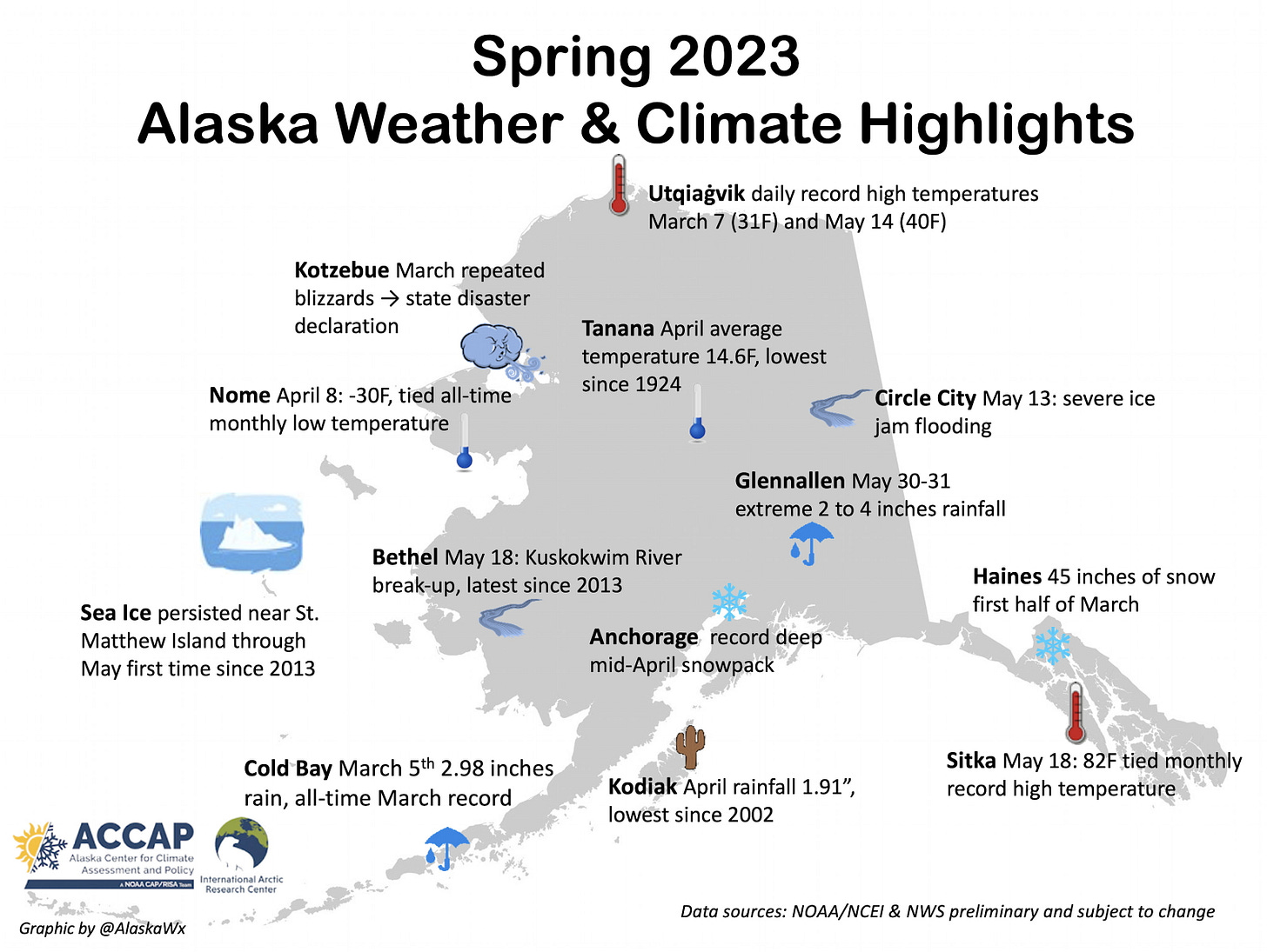
I create graphics with seasonal and annual (occasionally monthly) highlights around Alaska, as in Fig. 4 for this Spring, mostly to have as a quick reference for significant events that might otherwise get buried in the flood of information and lost to memory., i.e. I find these become more valuable with time. More on the March storms in western Alaska in the post here and the April cold here and here.
Spring was significantly colder than average over a large portion of Alaska and the coolest since 2013. Statewide, March through May temperature averaged 2.4°F below the 1991-2020 baseline in ERA5 reanalysis. The coolest areas (relative to normal) were in Northwest Arctic Borough and the northwest Interior, while hardly anywhere in Alaska was significantly warmer than normal.

For Alaska as a whole the Spring 2023 total precipitation averaged 19 percent above normal. Most of northern and western Alaska had above normal precipitation while south of the Alaska Range departures were mixed and mostly not too far from average in ERA5 analysis.

Snowfall departures from average in the Spring were quite similar to precipitation departures from the Alaska Range northward since most precipitation until some time in May occurs as snow. There are some differences south of the Alaska Range. Overall, this was a comparatively snowy spring, with the statewide snowfall 25 percent above the 1991-2020 average.


