Extreme April Cold…Again
This time around Eastern Interior Alaska
Earlier this month western Alaska was the focus of extended historic level cold. The eastern Interior was also colder than normal, but not down at record levels. But now a new shot of cold air from the Canadian high Arctic has brought a short-lived but intense burst of cold and strong winds to the Eastern and central Interior and western Yukon Territory, with some places having coldest weather on record this late in April, at least in terms of daily high temperatures. In some ways this was similar to the April 2021 and April 2022 Arctic air intrusions: short but sharp.
Temperatures
Figure 1. plots high temperatures for April 23rd. A large area saw high temperatures 30F or more lower than normal. Most notable was the high of 13°F at Eagle (NWS cooperative observer).1 While there are multi-year gaps in Eagle climate observations since the first observations in 1901, the high of 13°F is the lowest high temperature this late in the season on record. At Fairbanks Airport, the high of 17°F was easily a record for the date (old record 21°F in 1948) but not a record for lowest high temperature so late in the season, as on May 2, 1945 the high temperature was also 17°F. Similarly at Ft. Greely near Delta Junction, the high of 18°F was a daily record but 1964 brought even colder weather the second week in May.

Low temperatures were not close to record levels (in places were there are long term climate observations) during this event due to the persistent winds and in some areas clouds: the airmass was plenty cold enough but surface temperature inversions never got a chance to form.
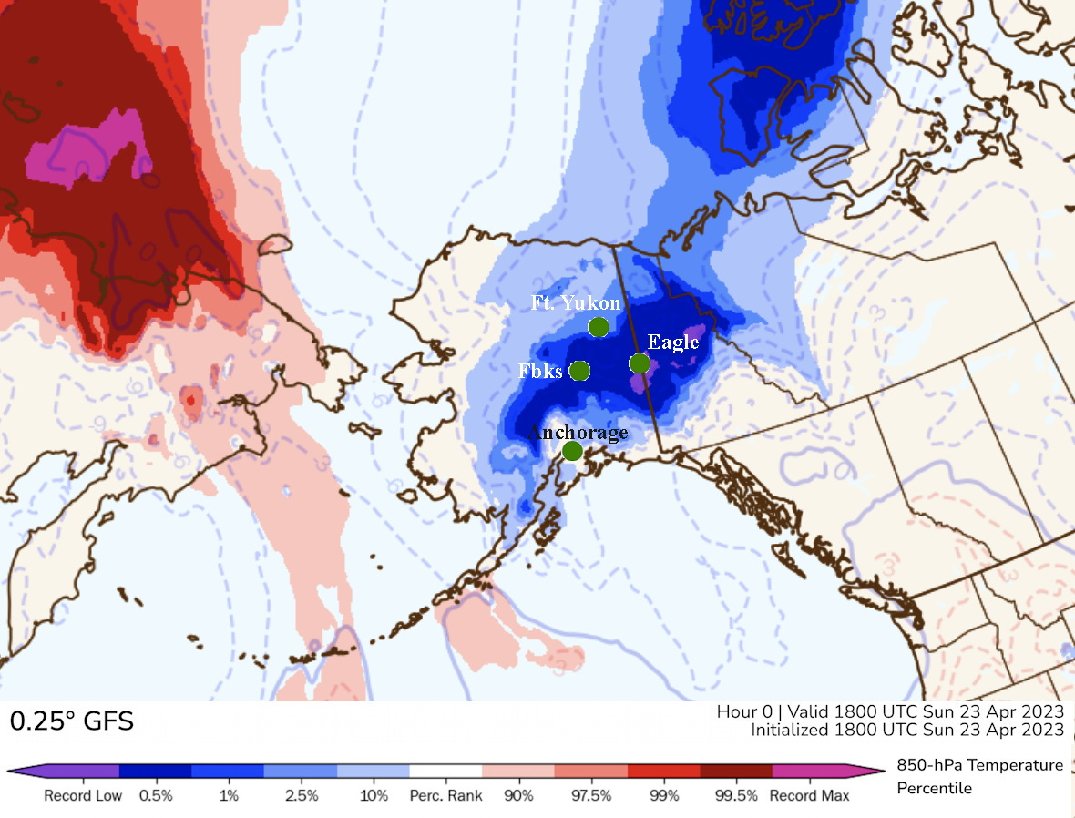
Figure 2. shows the larger view, with the color field showing how unusual the 850 hPa (about 5000 ft MSL) temperatures at 10am AKDT April 23 were for this time year. The darkest blue colors show were temperatures have been lower only a few time (~0.5%) during the 43-year baseline, while the small areas near Eagle the 10am temperatures were at record low levels for this period. Note the connection of coldest air over Alaska and Yukon to the unusally cold air over the western Canadian high Arctic: that was the source region for this cold snap.

Now to be reiterate, while this was an extreme cold outbreak for this late in the spring, the cold snaps of May 2-3, 1945 and especially May 8-10, 1964 were even more remarkable. At Fairbanks on May 8 and 9, 1964 the temperature failed to get out of the teens. Assuming a stationary climate, a high temperature of 19°F in the second week of May has a return interval of about 600 years. The low temperature of -1°F on the morning of May 9, 1964 is by more than two weeks the latest sub-zero temperature on record in Fairbanks.
Winds
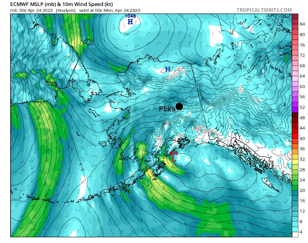
The cold airmass was accompanied by strong winds across most of the Interior that lasted in most areas two full days. At Eagle Summit (3650 ft MSL) on the Steese Highway, northeast of Fairbanks and well above tree-line, the average wind speed on April 23 was 36 mph with a peak wind of 49 mph (and temperatures at or below 0°F all day). Because of the configuration of the terrain at Eagle Summit, stronger southwest winds can occur in the winter but this is exceptional for northeast winds. The modeled sea level pressure and associated surface winds are shown in Fig 3. This is from global European Center model and is shown here to give some perspective of the strong pressure difference (about 50 hPa) between the North Slope high pressure centered near Umiat and the broad low pressure in the Gulf of Alaska.

Winds are very difficult to put into historical perspective because of multiple important changes in instrumentation and exposure over the decades. Also, winds over land are so highly variable at very small space and time scales that the current generation of climate reanalysis models are not well suited to the task. But for Fairbanks Airport, April 22 and 23 were exceptionally windy by any metric. On April 22nd the average windspeed was 18.3 mph and on the 23rd the average sustained wind speed was 20.9 mph. Daily average wind speeds of 20 mph or higher are extremely rare in Fairbanks: this was only the 4th day since 1975 to reach that threshold. This was the highest daily average speed on any day since March 21, 2005 (22.3 mph) and also appears to be the windiest April day on record at the Fairbanks Airport (since 1952). The windiest April day previously was April 20, 1965 at 20.0 mph in a nearly identical meteorological situation: a strong push of unusually cold air from the northeast. However, the wind gusts in this event were not as high as might have been expected: the peak wind at the airport of 36 mph has been exceeded in April multiple times, most recently 39 mph on April 5, 2020 and 47 mph on April 19, 2015. This might account for the relative lack of power outages in the Fairbanks area during this event.
Technical details:
Tropical Tidbits model graphics available at https://www.tropicaltidbits.com/analysis/models/
PolarWx model graphics at http://arctic.som.ou.edu/tburg/models/
Fairbanks Airport daily average wind speeds extracted using the cli-MATE application from the Midwest Regional Climate Center at https://mrcc.purdue.edu/CLIMATE/
The highest wind speed averages returned by cli-MATE have been cross-checked with the values published by NOAA in Local Climatological Data and I take the LCD values to be authoritative.
The cooperative observation at Eagle is made about 8am each morning, so the high of 13F is entered as part of the April 24 observation. Of course, this time of year the reported high temperature nearly always reflects the highest temperature the previous afternoon.


Anything that happens n times can happen n + 1 times