


April Cold Snap in Western Alaska
Historic Late Season Cold…Again

What’s Happened
April average temperatures have warmed significantly over nearly all of Alaska in the past 50 years. However, in the past three years, April has seen historical level cold outbreaks in somewhere in Alaska: in 2021, extreme cold April 4-12 was centered over the central and eastern Interior and eastern Gulf of Alaska coast; in 2022 the cold snap was shorter but still locally record setting, primarily in the western Interior. This April the record cold has been centered over western Alaska. Figure 1 shows some of the highlights of the cold snap. Keep in mind that the only places in this region with long term climate observations are Kotzebue, Nome, McGrath and Bethel.
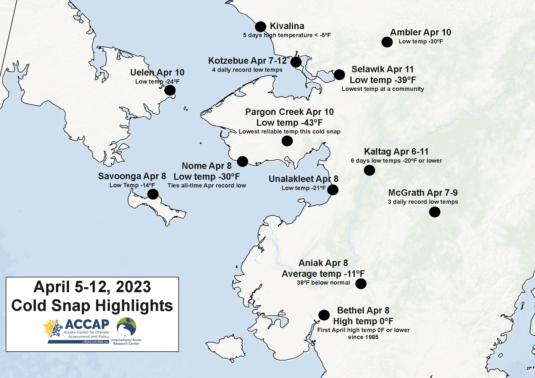
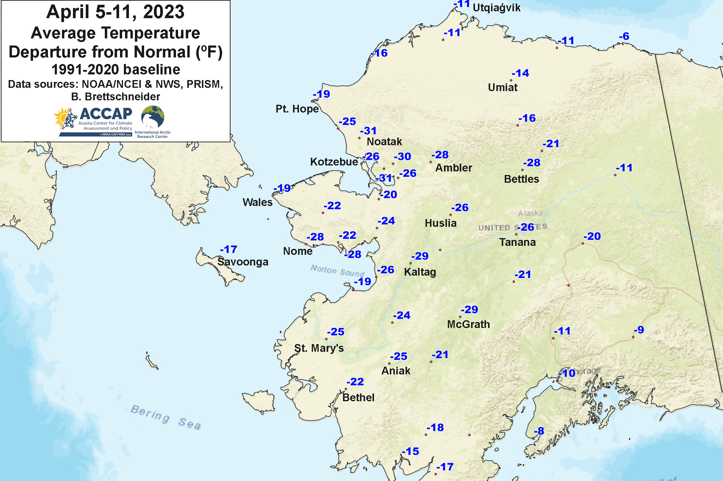
Figure 2 plots the average daily temperature departure for the week of April 5-11, 2023, which was the coldest 7-day period in most of western Alaska. The largest departure are clustered in northwest Alaska in the area around Kotzebue but some places on the Seward Peninsula and western Interior were nearly as far below normal. At Nome, the average temperature of -10.5F is the second lowest weekly average temperature in the past 117 years. The only colder week was April 5-11, 1920, when the average was -11.3F. At Kotzebue, the average temperature of -15.1 was the second coldest April week, with only Apr 1-7, 1943 colder (but there were no climate observations at Kotzebue in the 1920s). McGrath also finished up with the second coldest April week, with an average temperature April 5-11 of -3.1F (climate observations since 1941).
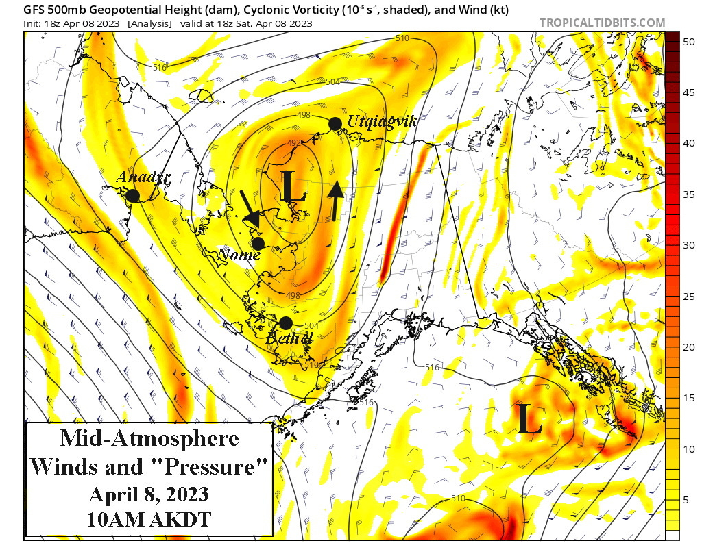
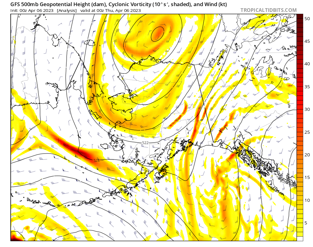
A common question in recent days has been “why?” Western Alaska sometimes sees wintery temperatures in the spring from big high pressure originating over eastern Siberia that moves east into Chukotka. However, that's NOT what happened in this event. Rather, a tight "ball" of cold air that on April 2 was centered over the East Siberian Sea west of Wrangel Island moved slowly but steadily eastward and was northeast of Utqiaġvik by the afternoon of April 5. But then things got weird. Because of the details of the wind flow within this "cold ball" and larger jet stream factors, this feature stopped moving east and by early April 6 was moving southwest and wound up centered just north of Kotzebue by the morning of April 8, where it then stalled out for a few days before moving northeast. Figure 3a shows the analysis of “pressure”, winds and “spin” at 10am Saturday April 8, near the peak of the cold in many areas, when the circulation around this "cold ball" covered all of western Alaska, from north of Utqiaġvik south to Bristol Bay and from eastern Chukotka to the western Interior. Fig. 3b shows a 6-day animation of the “cold ball”. Atmospheric pressure during this cold snap have not been notably high. Because of the spin of the "cold ball" this is actually a low pressure system aloft, and at other most times of year there would have been much more cloudiness with a feature like this. But this time of year, with sea ice near it's maximum thickness over the high Arctic, there was very limited moisture available to entrain into the cold ball, and the result was mostly clear skies and record cold for so late in season.
Why so Cold?
An intriguing question which I don’t have an answer to is: why have 4 years in the past 11 (2013, 2021, 2022 and 2023) brought historic level April cold to Alaska? It could of course be nothing more than random variability. But much as warming Arctic may be resulting in an increasingly “wavy” jet stream and bring more severe cold outbreaks to mid-latitudes in winter, are we experiencing something similar with these cold core lows over the “lower” high latitudes in the spring? I don’t know, but it does sound like a potentially interesting research topic.
Seems like it has to have something to do ice warming. Not even necessarily ice thaw - so much cold storage being lost .... earth's refrigerator giving it up?
Any other circum-arctic April cold ball systems?