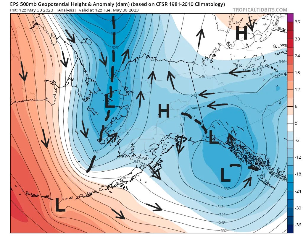
The last days of May have brought unusually chilly and in some areas wet weather to parts of Alaska and the southern Yukon, from the Panhandle to the Bering Strait. This widely inclement weather was not the result of one gaint weather system. Rather, multiple slow moving low pressure systems aloft were the culprit. At the same time, modest high pressure aloft extending from the Northwest Territories southwestward in northeast Alaska made for pleasant late May weather on the northern Yukon and much of northern Alaska. Figure 1. Shows the mid-atmosphere (roughtly 18,000 ft, 5.5km AGL) flow pattern as of 4am AKDT Tuesday May 30. I’ve annotated the wind flow and high and low centers on the graphic. You can think of the color field as showing areas of high or low pressure relative to the average for this time of year: warm colors = higher pressures, cool colors=lower pressure. The dashed lines represented troughs of low pressure and are associated with abrupt shifts in wind direction.

Temperatures
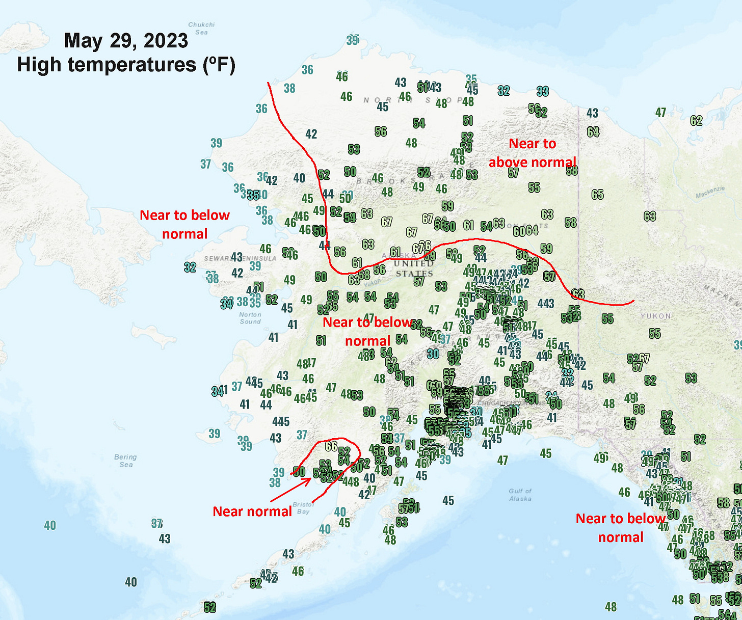
The plot in Fig 2. shows high temperatures on Monday May 29. As you might expect from the upper air pattern, much of mainland Alaska and the Yukon north of the Yukon River had daily high temperatures near to above normal, while the areas more directly influenced by the low pressure centers were cooler (relative to normal).

On May 30th many places in the Tanana Valley saw the lowest high temperatures for the date since the 1930s. Fairbanks Airport high temperature of 50F (10.0C) is the lowest daily high temperature this late in the season since June 4, 2006. Some places in the Copper River basin and upper Tanana Valley, none of which have consistent climate records prior to the early 1940s, set record low high temperatures for the date, including Gulkana 43F (6.1C)1 and Northway 47F (8.3C). On May 29th Juneau Airport recorded a record low maximum at 46F (7.8C). Overnight temperatures have not been notably low due to the persistent cloud cover.
Rain
Precipitation with these slow moving low pressure systems during the warm season can be locally heavy. Nenana (40 miles southwest of Fairbanks) recorded a whooping 1.11 inches at the airport in the 12 hours from 10pm May 29 to 10am May 30. That much precipitation in such a short period of time has an expected occurrence of about once in five years, but the fact that it occurred in May and not July or August is even more remarkable.2 The total rainfall for May 29 and 30 at Nenana was over 1.5 inches. For comparison Fairbanks airport had only 0.12 inches in the same time. Southeast Alaska also had significant rainfall May 28 to 30 but amounts were not excessive.
Snow
Perhaps most striking were the multiple reports of accumulating snow. The Glennallen area saw rain turn to snow during the early morning hours on May 30th and some areas had a small slushy accumulation before the precipitation turned back to rain. However, areas near Glennallen at just slightly higher elevations saw the snow last longer and accumulate. Figure 3 shows an Alaska DOT webcam on the Glenn Highway near Tolsona (west of Glennallen) that is about 600 feet higher elevation than Glennallen, which in this case made all the difference for snow accumulation. Photos posted on social media Tuesday morning May 30 also showed several inches of snow in the Tolsona area, while the FAA webcam at the Gulkana Airport cleared showed it was snowing but there was never any significant accumulation.

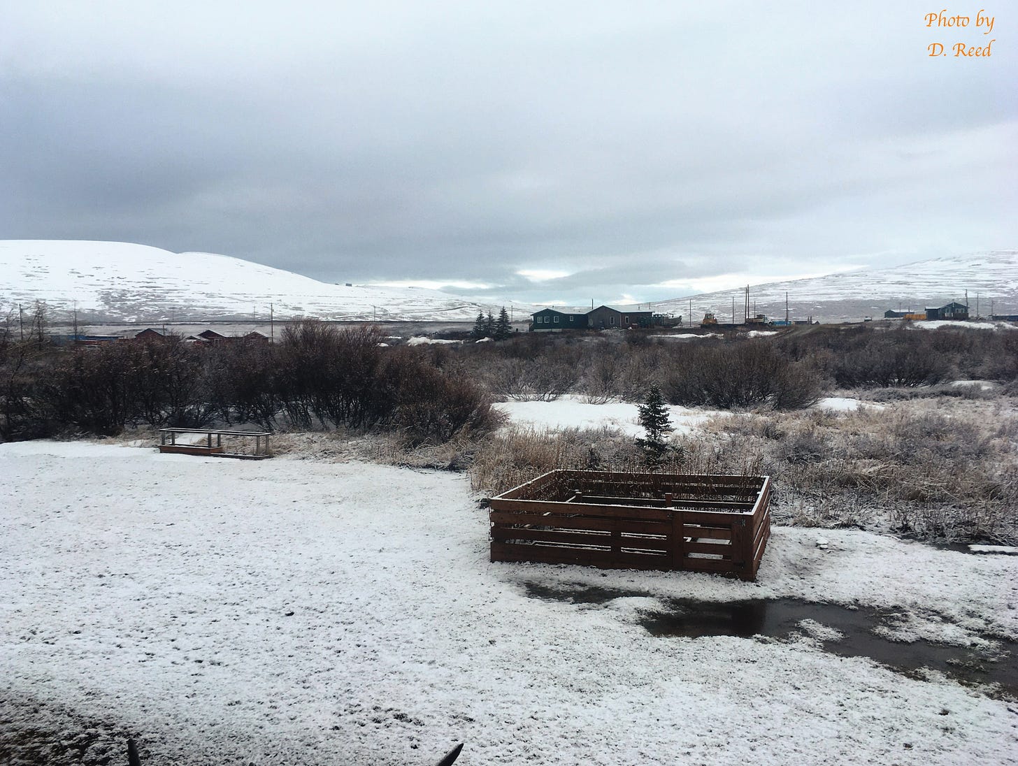
Snow fell across portions of western Alaska too on May 29 and 30th. From about Nome westward there was some accumulation, as seen in Fig. 4 from Dexter, Alaska (about 10 miles northeast of Nome). Accumulating snow in this part of Alaska this late in the season is unusual at low elevation but by no means unheard of; the first week of June 2021 Nome had accumulating snow on four days (which was very unusual). Snow also fell to the south and east of Nome: at Hooper Bay in the YK Delta snow was reported to fall for about an hour but without accumulating.

Technical details:
NWS Western Region surface weather observation plots at: https://www.wrh.noaa.gov/map/
Tropical Tidbits model graphics at: https://www.tropicaltidbits.com/analysis/models/
Nenana rainfall return interval extracted from NOAA Atlas 14 at: https://hdsc.nws.noaa.gov/pfds/pfds_map_ak.html
Telecommunications with the automated observation at Gulkana Airport have been mostly but not entirely inoperative for some days now. However, the observations are being made and the climate data for May 30 should be available in early June.
The only readily available estimates of precipitation frquency are for annual values. To the best of my knowledge there no readily available estimates for short duration precipitation in Alaska broken out at the seasonal or monthly time scales.


