Early March Storms in Western Alaska
Climate Change is Written All Over This

Summary
Western and northern Alaska was pounded by three separate storms between March 4 and 7th that brought widespread snow, blizzard conditions, record mild temperatures and in some areas significant rain. Cold Bay (lower Alaska Peninsula) set a new record 24-hour March precipitation record. Nome and Kotzebue (western Alaska) set March record high precipitation totals for both the 24-hour and multi-day time frames. Even more remarkably, at both communities the largest March storms in terms of the amount of precipitation have occurred in the past 15 years. This strongly suggests that these early spring storms are being intensified by the warming environment and so becoming more impactful.
Weather Situation and Impacts
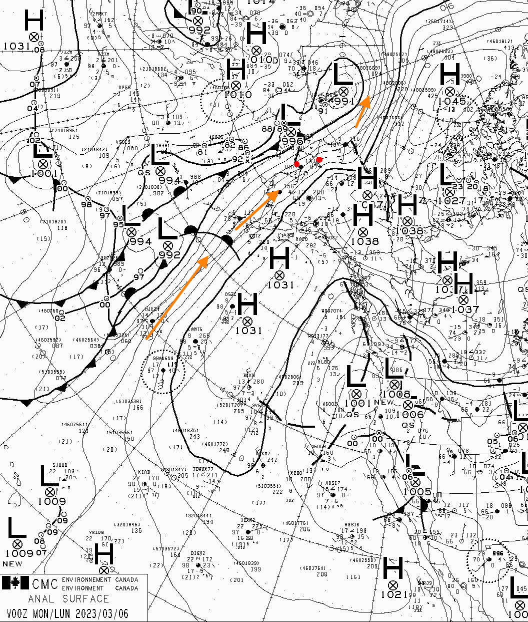
A storm moved along the Russian coast into the Gulf of Anadyr March 3 into March 4 and the associated weather front brought the first snow and blizzard conditions. The next storm moved almost due north from southwest of Adak into the Gulf of Anadyr on March 5 that brought a surge of deep moisture and really warm air. As this storm moved by a stationary weather front set up from the southern Chukchi Sea south through the Bering Strait to east of St Matthew Island with a series of low pressure centers moving northward along the front. To the east of this front more snow and rain fell on March 6. Figure 1 shows the surface analysis at 3pm AKST March 5th courtesy of Environment and Climate Change Canada.
Kotzebue was especially hard hit. Back-to-back blizzards created massive drifts in town, blocking access to buildings and critical infrastructure as illustrated in Fig. 2, prompting the city and state to issue emergency disaster declarations and a “boil water” advisory. Winds at the Kotzebue Airport averaged over 35 mph on March 4 and 5th and peaked at 71mph. Note that while functioning during the event, communications with the automated weather station were unreliable during the storm so at this time we can’t report e.g. hours at blizzard conditions. The situation at Kotzebue was reminiscent of the repeated storms of March 2009 (see this blog post for lots of photos of that memorable time).

At Nome, the storms started as snow with blizzard conditions on March 4th but by late afternoon on March 5th there was rain with the snow. Precipitation in Nome varied between rain and snow before ending as some snow on the evening of the 6th, with ice and slushy snow pack remaining in the aftermath. Winds were not quite as strong at Nome, with a peak wind of 45 mph on the 4th, but Teller reported winds as high 71 mph.
The Tropical Connection
Integrated water vapor transport (IVT) is a measure of the amount of water vapor in the atmosphere that is being moved along by the winds, and has become an important marker for extreme precipitation events in Alaska and is widely used as a tracker of “atmospheric rivers”. This event was no exception. Fig 3. shows the March 5th 9am AKST initialization of IVT from the US Global Forecast System (GFS) weather model. The flow from the subtropical Pacific direct to the western Alaska Arctic is clear. Like many other extreme events that have impacted Alaska in recent years, the basic pattern was well forecast by the global weather models.

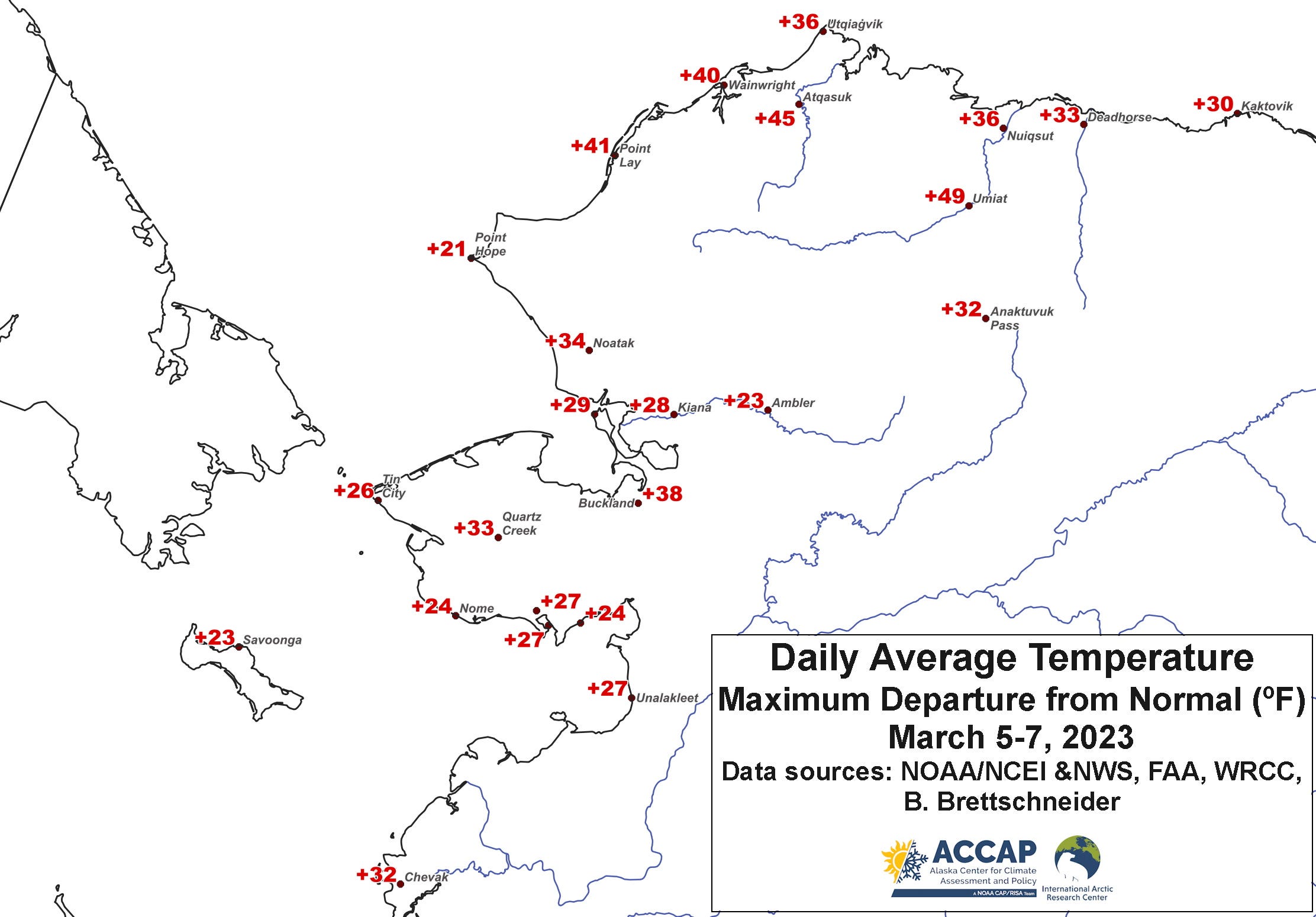
With moisture from the subtropical Pacific comes extremely warm air. Figure 4 shows the highest single day departure from the 1991-2020 normal between March 5 and 7th. Notice a number of places on the North Slope had a day when the average temperature was more than 40°F above normal. Daily record temperatures (including highest daily low temperatures) were set from the Pribilof Islands to the North Slope.
Climate Perspective
From the climate perspective, the most outstanding feature of this stormy weather was the high precipitation.
At Cold Bay, a total of 2.98 inches of rain fell on the 5th, obliterating the previous March record 24-hour precipitation of 2.35 inches in March 14-15, 2002. This included 1.03 inches of rain between noon and 6pm AKST, which is a notable rainfall rate any time of the year at Cold Bay.
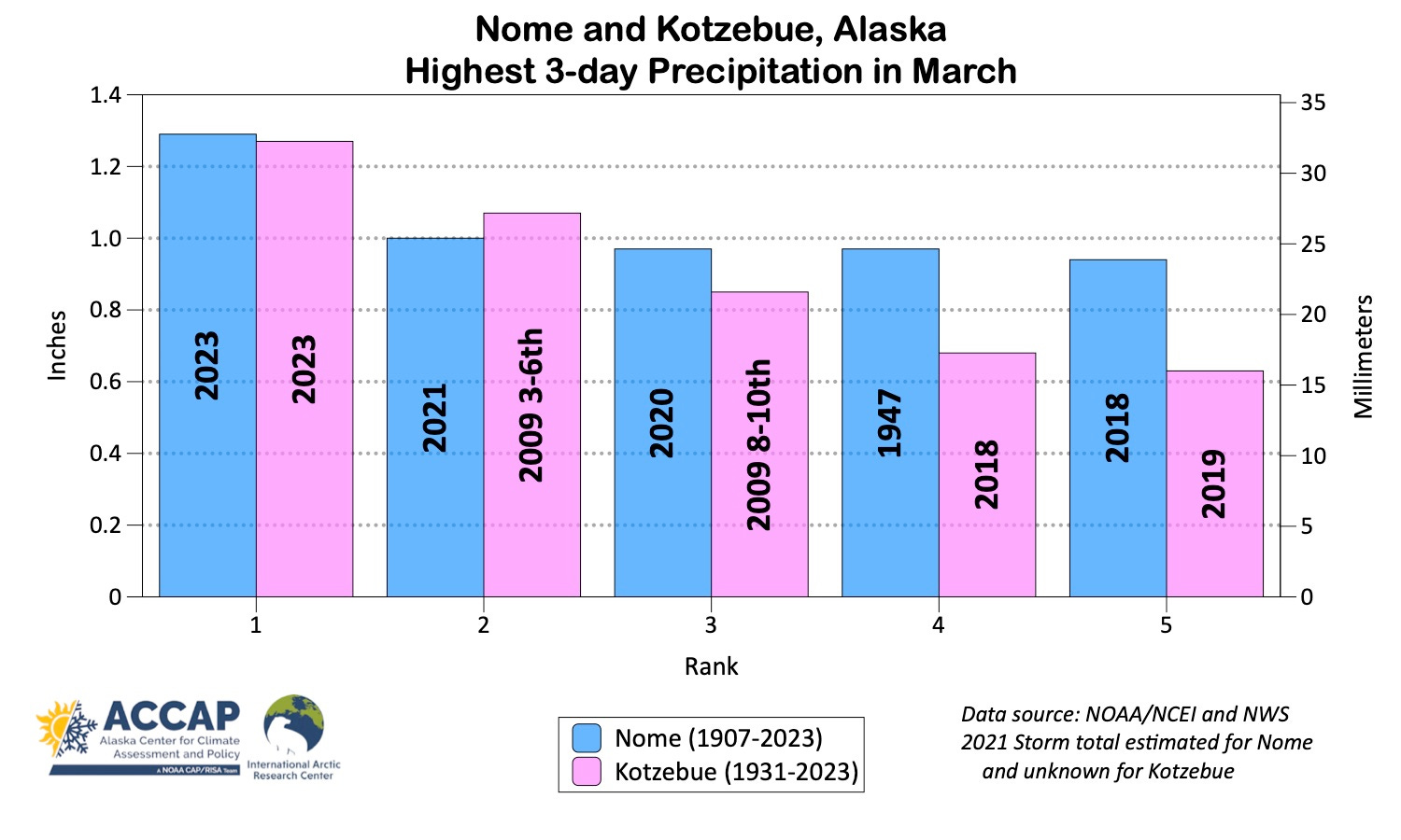
At Nome, the maximum 24 hour precipitation of 0.71 inches on March 6 is a new March record for the airport and highest 24 hour total in March since 0.74 inches fell March 3-4, 1945 (when the Weather Bureau office was in town). The March 4-6 total precipitation at Nome of 1.29 inches was easily a new record 3-day total.
Similarly at Kotzebue, the 24 hour precipitation of 0.73 inches March 4-5th is a new monthly record, breaking the previous record of 0.64 inches on March 5, 2009. And the 3-day total precipitation total of 1.27 inches March 4-6 is also easily a record for March.
A significant unknown in this analysis is a storm that occurred March 6-9, 2021. The NWS automated weather stations at both Nome and Kotzebue were not functional during that storm. Since there is no backup, there are no measurements of precipitation. At Nome it was obvious from size of snow drifts that this was a major precipitation event. This was supported by weather models at the time and in hindsight by ERA5 reanalysis. The situation is less clear at Kotzebue, where overall it appeared the precipitation was probably not quite extreme, though could have easily been in the top ten for this time of year.
Fig. 3 shows the top five March 3-day precipitation totals for Nome and Kotzebue. Notice that at Nome four of the top five events have occurred since 2018 and at Kotzebue all of the top five have occurred since 2009 (yes, the two separate events in March 2009 are correct: that was an incredibly snowy week at Kotzebue). Given the long period of record at both locations and attendant difficulties with automated measurements of winter precipitation in tundra environments, there’s basically no chance that this is just random variability. Rather, thinning sea ice and increasing ocean temperatures south Bering Sea ice edge are almost certainly evaporating more water vapor to the atmosphere that these early spring storms are tapping into.