Some of the warmest weather on record so early in the season occurred in Southeast Alaska May 16-19, 2023. Most long term climate sites set one or more daily record high temperatures and some places saw the warmest weather so early in season.
What Happened?
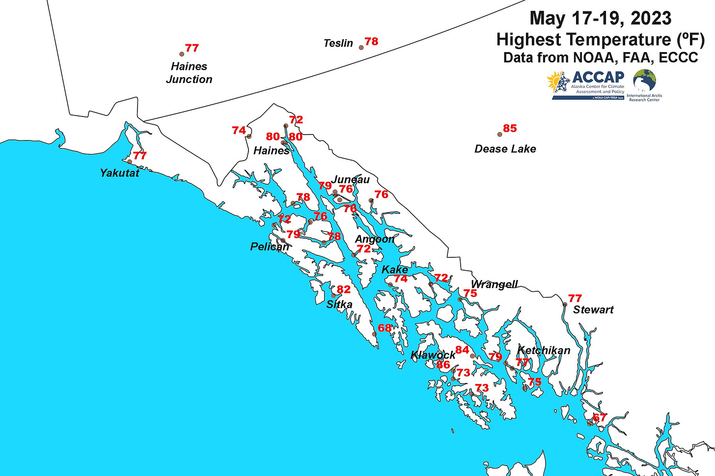
Most notably, the temperature at the Sitka Airport briefly rose to 82F (27.8C) on May 18th. This ties the monthly record high temperature previously recorded on May 21, 1963. Climate observations have been made at the Sitka airport since the late 1940s but with a few gaps. The NOAA Sitka Climate Reference Network Station is less than a mile north of downtown Sitka and recorded a high temperature on May 18th of 83F (28.3C). This automated climate station (established in summer 2005) is very close to the location of the old Sitka Magnetic Observatory cooperative site (observations 1899 to 1989), where the record high temperature for May was 85F (29.4C) also on May 21, 1963 but this year is the highest temperature so early in the season. Also of note was the high temperature at Haines Airport and at the Haines cooperative station of 80F (26.7C) on May 18th. This is the earliest date in the year at Haines with a temperature of 80F (26.7C) or higher in the past century. Other long term climate sites in the region that set daily records include Ketchikan, Yakutat and Juneau Airport (on two days).
Figure 1 shows the highest temperature during this event at a number of locations around Southeast. Klawock at 86F (30.0C) and Thorne Bay at 84F (28.9C) were the two highest reliable temperature reports

Summertime temperatures in Southeast Alaska sometimes show very large variations in short distances because of the interaction between the ocean cooled air in the lowest few hundred feet of the surface with warmer air over land and aloft, above the ocean cooled air. In this event, sea surface temperatures around Southeast were mostly near to a bit above 50F (10C). This battle between the cool marine air and much warmer air aloft and inland also accounts for sometimes dramatic temperature changes in very short time, as occurred at Sitka Airport on May 18th and plotted in Fig. 2: the temperature fell 20F (11C) in 30 minutes as winds switched from the east, bringing warm inland air to the airport, to a stiff southwest sea breeze marking the “slosh” of the marine layer.

These kinds of dramatic differences and changes in temperatures are common along coasts everywhere that ocean surface temperatures are routinely much colder than the land: the California coast is perhaps the best known example.
Why Was It So Hot?
During the week of May 16 Southeast Alaska was on the western edge of the warm high pressure aloft that has contributed to the early and severe wildfire season in British Columbia and Alberta. Figure 3 shows the mid-atmosphere steering flow on Thursday afternoon (Alaska Time) May 18. The strong high over northern British Columbia and lower pressure over the Gulf of Alaska combined to produce very warm low level air, mostly clear skies and the appropriate pressure pattern to allow most land areas to at least briefly get into that unseasonably warm air. This pattern is associated with temperature extremes both winter and summer and represents the “continental influence” for a region where the climate is dominated by maritime airmasses. In winter this pattern brings cold air and in some areas strong winds from Canada to Southeast (especially inner channels and northern Southeast) and in the summer unusual warmth.


In the SoCal area, we call the wind from inland a Santa Ana wind, if it is strong. I did not know that Sitka also had an offshore wind, but it makes sense.
Thanks, this was really interesting to read after experiencing that day in Sitka. It was especially interesting because I don't think we usually see the temperature peak so late in the day. It was ~73 for much of the afternoon, and 70s in Sitka always feels hot. People are surprised how many heat-related rescue calls we've had over the years when it gets into the 70s.
I went out that evening right at 6pm, and it was starting to feel cooler. I was really surprised to look down and see 83 on my truck's thermometer. I thought it was from engine heat, or having been parked in the sun earlier. Do you have any explanation why it felt cooler at 83 at 6pm than it did at 73 at ~4pm? I don't think it was just shade; if I remember right, the shade felt warmer in the 70s than when the temps read in the 80s. Was that warm air mass drier or something?