


2022 Alaska's Weather & Climate Highlights
Part 3: Temperatures and Wildfire

In this final recap of 2022 we’ll look at some temperature-related highlights and a short review of the eventful wildfire season. Other posts in this series:
Part 1: High Impact Events
Part 2: High Impacts and Precipitation and Snow Extremes
Temperatures
2022 was generally milder than 2020 and 2021 in Alaska but not at the record high levels of 2016 and 2019. Kotzebue (Northwest Arctic Borough), with an average temperature of 22.8F (-5.1C), was the only long term climate station with an average temperature below the NOAA 1991-2020 normal.
Notable annual average temperatures and ranks include:
Utqiaġvik: 15.8F (-9.0C), 6th warmest year (102 years of observations)
Anchorage: 39.2F (4.0C), 7th warmest year (69 years of observations)
Sitka: 46.8F (8.2C), 7th warmest year (75 years of observations)
Kodiak: 43.7F (6.5C,) tied for 8th warmest year (105 years of observations)
Nome: 30.2F (-1.0C) tied for 10th warmest (112 years of observations)
Statewide, the highest reliable temperature in 2022 was 89F (31.7C) at the NWS cooperative station at the US Customs Station on the Haines Highway on July 5th. This is the first time since 2014 that no climate station in Alaska reached 90F, but that is merely an artifact of available observations: Hyder, in southern Southeast with observations since 2002, almost certainly reached 90F or higher on June 27th but the cooperative station temperature sensor was not functioning between early January and early August. The lowest reliable temperature was -62F (-52.2C) at Chicken on three days in mid-December.
There were a few daily temperature extremes that were record setting at longer time scales. Cold Bay on April 7th saw the temperature drop to +7F (-13.9C), the lowest temperature so late in the season. Nome saw very warm weather in mid-May, including a low temperature of 50F (10.0C) on May 22nd, the earliest date in the year with a low temperature so high. In early June, several areas on the eastern Gulf of Alaska coast and northern Southeast set new records for highest temperatures so early in the summer. This included 83F (28.3C) at Juneau Airport on June 3rd and 82F (27.8C) at Yakutat on June 4th. And perhaps most outstanding, on December 5 the temperature at Utqiaġvik briefing spiked to 40F (+4.4C). This is the highest temperature on record not just for December or even the winter, but the highest on any date between October 30th and April 22nd. While the mid-December cold snap brought several days of very low temperatures to the eastern Interior and the Yukon Territory, the one significant record was set at Kenai (Southcentral), where the temperature dipped to -31F (-35.0C). This is the lowest December temperature there since 1970.
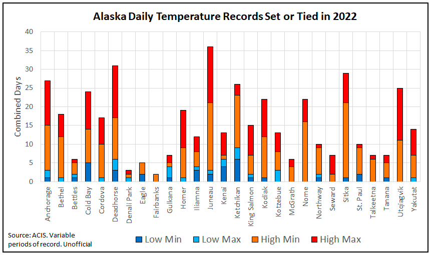
Brian Brettscheinder with NWS Alaska Region tracks daily temperature records set at most of the long term climate stations that are current active and the Fig. 1 summaries the record count. The immediate features that stands out is “warm” records far outnumber “cold” records and that overall coastal locations set more “warm” records in 2022 than inland locations. Now it is important to understand that the number of temperatures records is a complex interplay between the period of record length, the amount of missing data and what years observations are available. In this data set, most location records are based on observations since the early 1940s, but varies from 1900 for Eagle and 1901 for Tanana to 1952 for Anchorage and 1968 for Deadhorse.
Wildfire
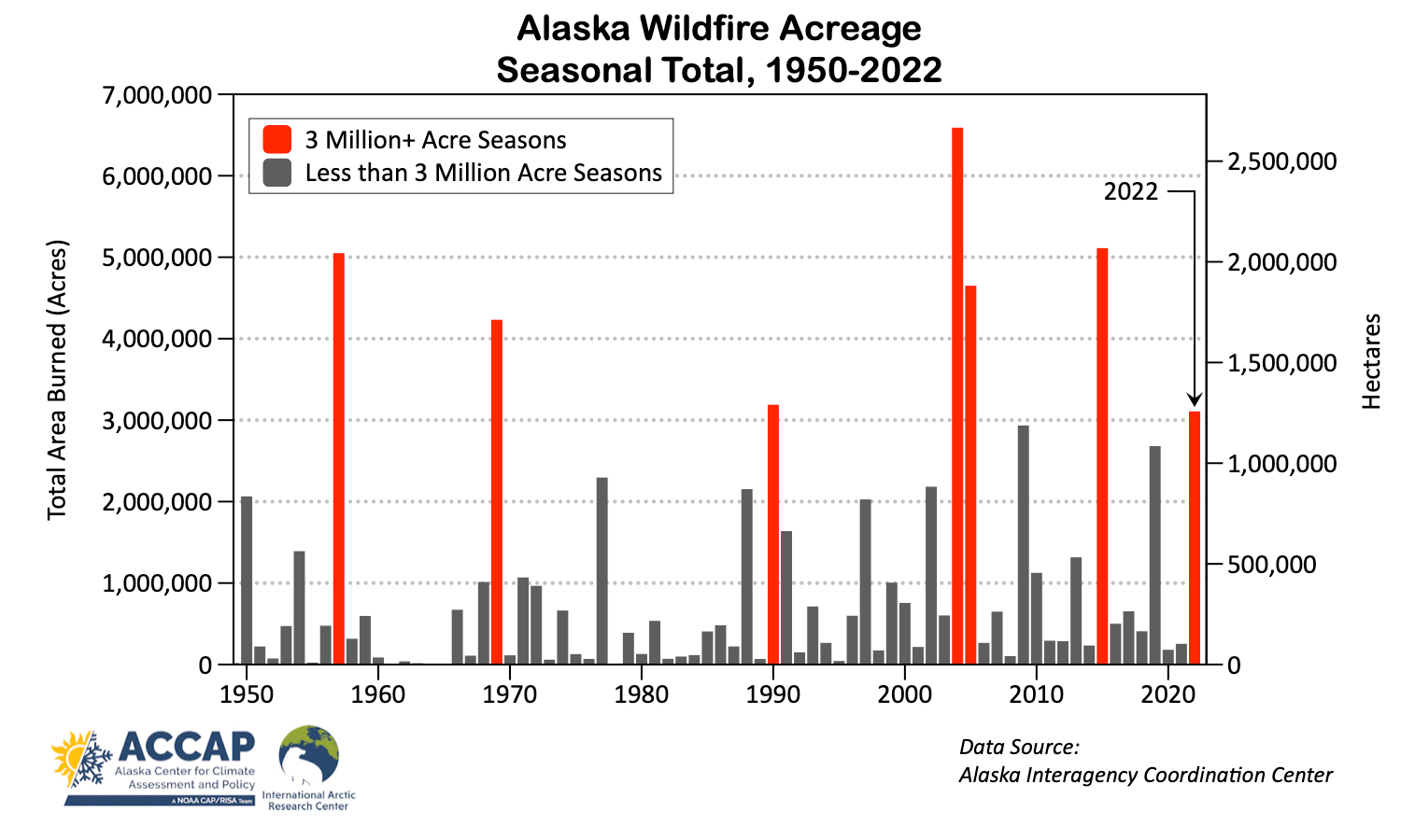
The 2022 wildfire season was intense but but short-lived. A total of 3.11 million acres (1.26 million ha) burned in the seven weeks between late May and mid-July. This is the seventh highest seasonal total since 1950, and the fourth year since 2004 to exceed 3 million acres (Fig. 2). Wildfires were spread across Interior and southwest Alaska, though there was a distinct lack of large fires in the Upper Tanana Valley and Fortymile County, likely a lingering effect of a near record deep spring snowpack. Fig. 3 plots most of the 2022 fire perimeters with some of the largest and most significant fires annotated.
The start of the season brought unprecedented widespread and large wildfires to Southwest Alaska, where early snowmelt and a warm and dry spring allowed for lightning started fires to pop up during a multi-day weather pattern conducive to thunderstorms set up over the region. The East Fork Fire near St. Mary’s became the largest documented (since the 1940s) fire in the Yukon-Kuskokwim Delta region at over 166,000 acres (67,400 ha) and was the largest wildfire in predominately tundra landscape in Alaska since the 2007 Anaktuvuk River fire. The Bristol Bay region1 historically has had very little wildfire activity, but in 2022 a total 415,000 acres (168,000 ha) burned, which is more than the total area burned between 1950 and 2021. In mid-June, thunderstorm activity increased over Interior Alaska, where the Minto Lakes and Clear Fires threatened infrastructure. For Alaska as a whole, the 1 million acres burned threshold was surpassed on June 18th; this appears to be the earliest date in the season to reach that level in at least 60 years.

The season came to a hard stop in mid-July when the weather pattern change to cooler and wetter one. While this does not happen quite so abruptly every season, it’s usual for the wildfire season to slow dramatically in July, as north of the Alaska Range the "rainy season" often kicks into high gear. This year there was unusually high amount of lighting in early August in the Interior, but by then it was too late in the season to get new fires to grow due to the lower temperatures and higher relative humidity that comes with the return of darkness at night.
The Alaska Interagency Coordination Center divides Alaska (excluding the Aleutains and Bering Sea island) into 18 “Predictive Service Areas” (PSA) and are used for weather, climate and fuels monitoring and forecasting. The Bristol Bay PSA extends from north of Ilimana Lake west to Goodnews Bays and south along the Alaska Peninsula to near Port Heiden. The PSA are distinct from the administrative divisions used for wildfire monitoring and suppression.