


2022: Alaska's Weather & Climate Highlights
Part 2: High Impacts and Precipitation and Snow Extremes

This is the the second post reviewing Alaska weather and climate in 2022. Part 1 (here) reviewed some of the high impacts events. In this post we’ll add a few more events and then review of the noteworthy precipitation (and snow) extremes. Part 3 will tackle Alaska wildfire and temperature related extremes in 2022.
High Impact Events
Coastal Flooding: Just three weeks after ex-Typhoon Merbok a record strong storm tracked across Chukotka (far eastern Russia) before crossing into the far western Chukchi Sea just south of Wrangel Island. Significant damage was reported from some Chukotka communities. Although the storm was far to the west of Alaska, there was some minor coastal flooding at Kotzebue and Kivalina but much more substantial flooding at Utqiaġvik, where Ebon Hopson Street was flooded for more than a day and the road to Point Barrow was extensively eroded.
Flash Flooding: Locally heavy rainfall combined with high elevation snowmelt led to multiple road washouts due to flash flooding on the Richardson Highway south of Delta Junction in an 18 mile stretch between Black Rapids and Fielding Lake July 10th to 12th. Most extreme was the washout at Bear Creek (Fig.1), where more than 200 feet (65 meters) of road the road was obliterated by the rushing waters. The Richardson Highway was closed to through traffic for five days and there was damage to a fiber optics cable that runs along the road corridor.

Precipitation Extremes
A short-lived but intense drought developed after spring snow melt in southwest Alaska, and then spread into southcentral Alaska and then the western and central Interior. The drought peaked in early July, as shown in Fig. 2, when about 45 percent of Alaska was analyzed by the US Drought Monitor as being abnormally dry or in drought, with a small area in the upper Kuskokwm River valley and the area from the northwest Kenai Peninsula northward across Anchorage and into the lower Susitna valley in severe drought. Talkeetna recorded only 0.44 inches (11mm) precipitation April through June, easily the lowest on record, and Anchorage Airport only reported 0.49 inches (12mm) in this period, also a record lowest late spring precipitation. In the Interior from Fairbanks southeastward, precipitation was also very low but drought was not as severe due to the (near) record deep end of spring snow pack and a slow meltout.

Soggy Late Summer: in one of the more dramatic climate flip-flops in recent times, southcentral Alaska went from a (near) record dry late spring with moderate to severe drought to frequent and heavy rainfall late summer. After setting a record for driest April through June, Talkeetna turned around and set the record for highest precipitation July though September, with 20.28 inches (515mm) over the three months. At Anchorage, there were 48 days in August and September with measurable rain (0.01 inches/0.2mm or more), by far the most in any two-month period.
Record Precipitation
Fig. 3 includes some of the 2022 highlights, including the record high annual precipitation totals at Anchorage (28.60 inches, 726mm), Juneau (88.31 inches, 2243mm) and Gulkana (22.26 inches, 565mm). King Salmon gets an honorable mention: 30.54 inches (776mm) precipitation in 2022 is the second highest annual precipitation total on record, just shy of the 30.64 inches (778mm) in 2018.

Snow Highlights
Heavy snow in the Yakutat area during December and early January pushed snow depths in town up to five to six feet (1.8 meters), only to be followed by soaking rains that started on January 9. The National Guard was called in to assist with removal of the water-logged snow from building roofs.
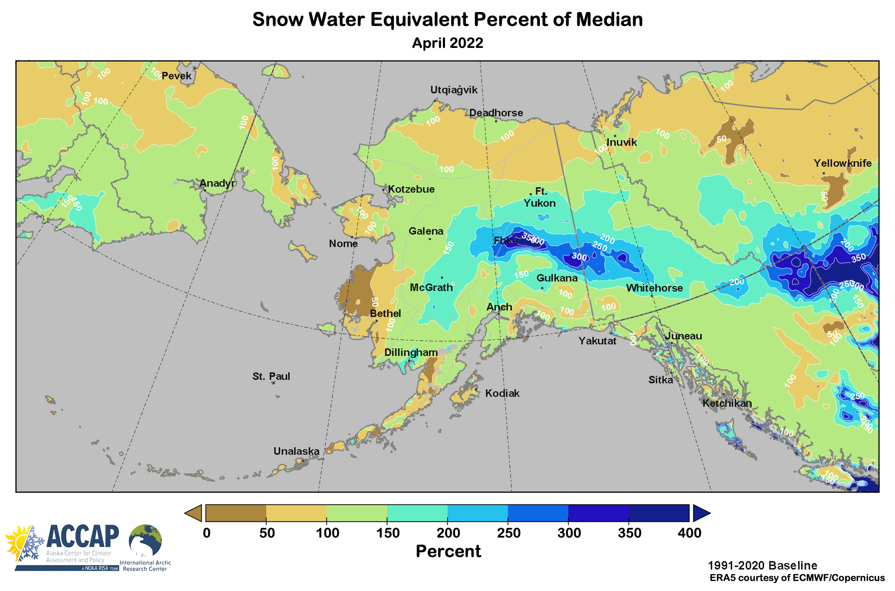
The end of season snowpack was exceptionally high across much of the central Interior eastward into Yukon Territory (Fig. 4), with some areas from Delta Junction to Northway recording the highest snowpack on record. A long term effect of this deep snowpack was to keep water levels high on the Tanana and Yukon Rivers well into summer, long after the spring break-up flooding had ended.
Accumulating snow in mid-summer is not too uncommon in Denali National Park at elevations above 3500 feet (~1050 meters) MSL, but is rare at the east end of the Park (Parks Highway corridor to headquarters. During the early morning hours of August 9th snow though, a cold rain changed to snow, with accumulating snow down below 1800 feet (550 meters) elevation. The climate station near Park headquarters reported 2 inches (5cm) accumulation. This was only the fourth occurrence in the past century of accumulating snow at headquarters between June 15th and August 15th. Slight accumulations were also reported along the Parks Highway between Denali Park and Cantwell and farther east on the Richardson Highway near Black Rapids.
Early autumn snowfall was very heavy in the Copper River basin and upper Tanana Valley. The NWS cooperative station at Glennallen reported 23.8 inches (60.5cm) of snow, the second highest October since observations began in 1966, and at Tok 28.2 inches (71.6cm) is the highest total since observations began in the late 1950s.
The heavy snow in early and mid December across much of southcentral was exceptional and although Anchorage was especially hard hit (see Anchorage Snowpocalypse for a review), the northwest Kenai Peninsula, lower Mat-Su Borough and the Cooper River basin also received one or more major snowstorm. The NWS cooperative climate observer at Glennallen reported 29 inches (74cm) of snow December 11 to 13, by far the highest storm total in more than 50 years of observations. The same storm produced over 20 inches of snow in parts of the Kenai and Soldotna areas on the Kenai Peninsula.