


2022: Alaska's Weather & Climate Highlights
Part 1: High Impact Events

Alaska is a big place and so there is often some weather or climate event of importance happening somewhere in the Great Land. And 2022 dished up a heaping serving of highlights (don’t we say this every year?). Some events produced immediate, serious and widespread impacts, others were more localized, some were more of a climate science interest, and others may be “gee-whiz” statistics now but impacts may show up in the months or years to come. This is the first in a series of posts (2 or 3) with the obligatory year-end roundup. Let’s start with a sampling of some of the highest impact weather-related events in Alaska in 2022.
Ex-Typhoon Merbok
Meteorology: Typhoon Merbok formed west of Wake Island on September 11th and moved north-northeast across exceptionally warm waters, crossing into the Bering Sea near Sheyma, Alaska (track shown in Fig. 1). The typhoon lost tropical storm structure prior to reaching the Aleutian Islands but then deepened to 937 hPa 300 miles northeast of Shemya during the early morning hours of September 16th. The storm moved through the Bering Strait on September 18th and dissipated September 19th northwest of Point Hope, Alaska. This was easily the strongest storm in the Bering Sea so early in the season (since at least 1950) and produced the most widespread and significant coast flooding since the Bering Sea Superstorm of November 2011. A NOAA buoy west of the Pribilof Islands measured a combined sea height of 52 ft (16m) on the 16th. Ocean water levels at Nome were the highest since the great storm of November 1974 and post-storm surveys at some communities such as Hooper Bay and Golovin showed ocean water levels reached higher than any known storm in the past.
Impacts: there was damage along 1000 miles of coastline from Kuskokwim Bay to the Bering Strait. There was community infrastructure damage and residences, and in some areas there was a major loss of camp infrastructure critical to subsistence activities. Severe beach erosion occurred in many areas, impacting roads and protective dunes. At Shaktoolik, the berm that was created to product the community water supply from salt water inundation during storms was almost completely washed away. Even away from the immediate coast, high ocean water levels pushed up coastal rivers, resulted in severe erosion and the loss of more buildings at Newtok. At Chevak, many boats tied up on the river bank were swept away. Both state and federal disaster declarations were issued for the impacts from ex-Merbok.

Extreme Wind Storm Mat-Su Borough
Meteorology: January 1st through 3rd saw cold high pressure across Interior Alaska and Cooper River basin contrasting with strong low pressure in the Gulf of Alaska, and the difference in pressure resulted in sustained strong winds across the lower Matanuska and Susitna valleys. During much of the wind storm temperatures were in the -10F to -20F range, creating extremely low wind chills. The average sustained wind speed at the Wasilla Airport on January 2nd was 48 mph and wind gusts over 90 mph were reported in some areas.
Impacts: Millions of dollars of damage to buildings and property was reported in the greater Palmer and Wasilla areas, including roofs torn off buildings, trucks blown off the Parks and Glenn Highways (Fig. 2) and small planes overturned at airports. Damage was so extensive that some places were without power for a week. The loss of power and low temperatures caused some homes and businesses to incur severe damage from frozen and burst water pipes. Both state and federal disaster declarations were issued for the damage from these winds.

Anchorage Heavy Snow
Meteorology: Three major snowstorms between December 6th and 15th piled up 40 to 50 inches of snow in the Anchorage area. At Anchorage International Airport, a total of 41.1 inches (104.4 cm) of snow fell in 11 days, the second highest 11 day total on record. The record remains 44.6 inches (113.3 cm) in 11 days in February 1996. There’s much more detail about Snowpocalypse 2022 in this post.
Impacts: Schools were closed for five days prior to the holiday break and many businesses closed or reduced hours, in part becuase some employees were unable to make the commute. There were sustained and widespread travel difficulties in and through Anchorage, as two weeks after the snows ended there were still many areas needing snow removal.
Summer Wildfire and Smoke
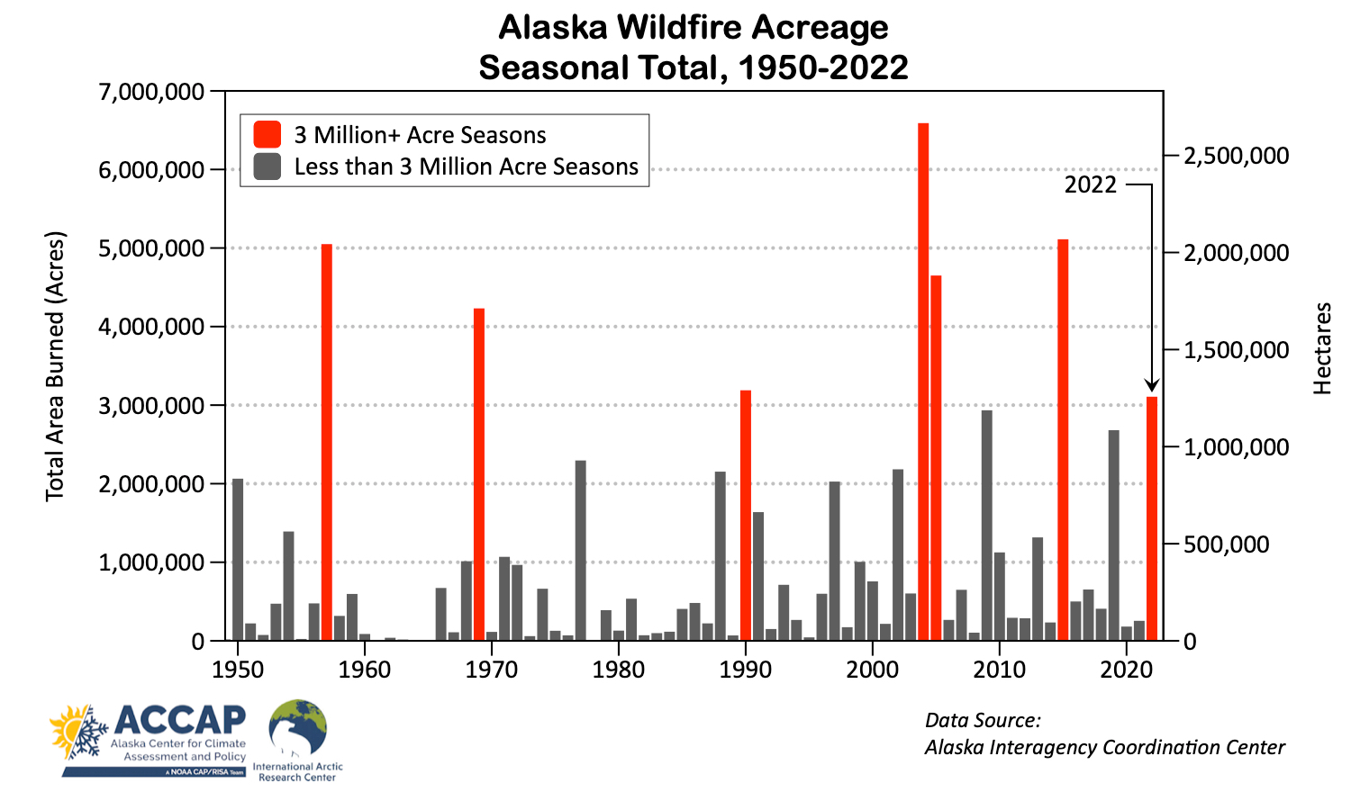
Meteorology: The stage was set with an exceptionally dry spring, and in southwest Alaska earlier than average snowmelt. The season started very early, when in mid-April the Kwethluk Fire, southeast of Bethel, burned 10,300 acres (4170 ha), which is the largest known April wildfire in Alaska. The end of May and first days of June brought thunderstorms to southwest Alaska and lightning from these storms ignited many fires. Starting in mid-June thunderstorms developed in the Interior and started more fires. The 2022 wildfire was compressed into about seven weeks between the end of May and the middle of July, which is not unusual. The total area burned in Alaska of 3.11 million acres (1.26 million hectares) is the seventh highest total since 1950 and acreage burned in southwest Alaska (YK Delta to Bristol Bay) was by far the highest on record. The East Fork Fire, north of St. Mary’s, burned 166,760 acres (67,500 ha) and was the largest Alaska wildfire in a predominately tundra ecosystem since 2007. This is also the largest known (since 1940s) wildfire in the Yukon-Kuskokwim delta region.
Impacts: The East Fork, Clear and Minto Lakes Fires all threatened communities and homes, with voluntary evacuations in some cases. A state disaster declaration was issued for communities threatened by the East Fork Fire. Most areas in mainland Alaska had at least a day or two of smoke, and in parts of the Interior the smoke was almost unrelenting in early July. Fairbanks had more than 400 hours with visibility reducing smoke, roughly corresponding to air quality of “unhealthy for sensitive groups” or worse. This was the second greatest hourly total of smoke reduced visibility in the past 70 years (though 2004 was far higher). Very unusually, portions of western Alaska were inundated with thick wildfire smoke on July 1st when an northward moving weather front pushed dense smoke from fires near Iliamna Lake northwestward hundreds of miles. At Nome, more than 400 miles from the fires, air quality was in the “hazardous” category for ten hours and was the densest wildfire smoke since July 1977.
Spring Break-up Flooding
Meteorology: a (near) record high spring snowpack in eastern Interior, the Alaska Range and much of the Yukon Territory raised the threat of significant Spring break-up flooding on Alaska’s major rivers. Thanks to a protracted melt with near to below normal temperatures during April and early May, there was less flooding than might have been had there been a rapid warm-up, but flooding was still significant.
Impacts: Manley Hot Springs was hard hit when much of the town flooded on May 6th after an ice jam formed downriver on the Tanana River and caused water to back up into and overfill Manley Slough. There was significant damage to homes, infrastructure and roads with communications and power outages. A week after the water receded there were still about 50 people displaced. On May 8th ice jams produced flooding at the middle Kuskokwim River communities of Sleetmute and Red Devil, and on May 11th upriver at McGrath. High water on the Cooper River near Glennallen started May 9th and persisted into June. This produced both local ice jam flooding in mid-May and then severe river bank erosion later in May, and at least one home was lost to the river on May 30th. Both state and federal disaster declarations were issued for the damage from these flooding events.
