

Early Autumn 2024 Arctic Sea Ice
Slow start to the sea-ice growing season

Sea ice in the Arctic reached the 2024 seasonal minimum extent in mid-September (details in my post here). Since then, ice extent has been only slowly increasing. Figure 1 shows the AMSR2 sea ice concentration as of October 11, 2024, with the pack ice still far from Arctic coasts except along the northern Canadian Islands and north and northeast coasts of Greenland.
Figure 2, from the National Snow and Ice Data Center, shows the daily sea ice extent on October 11 at 5.06 million km². This is 34 percent below the 1981-2010 average for the date and is the fourth lowest for October 11, with only 2012, 2019 and 2020 lower.
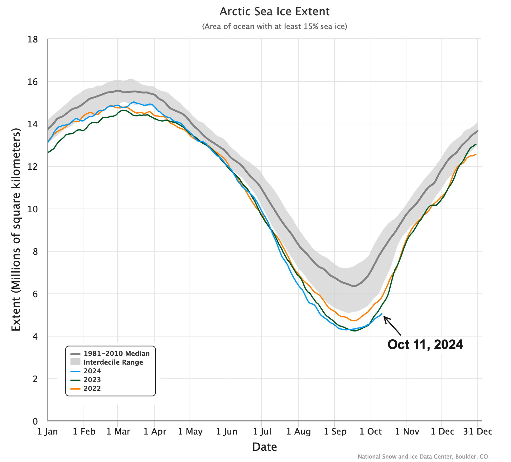
The October 11 sea ice extent of 5.06 million km² is an increase of only 780,000 km² (18 percent) from the minimum extent one month prior. This is an unusually small increase, as seen in Fig. 3. In fact, in terms of areal increase, this is the third lowest in the 46 years of the satellite era, with only 19951 and 2018 having less of an increase.

The data of Arctic sea ice minimum extent varies year to year, though in most years it occurs within five days of September 14. This year, the minimum extent occurred on September 11 in NSIDC data. Looking at the rate of ice extent increase after the minimum, this year comes in at second lowest, behind only 1995.
Sea Ice thickness
Arctic-wide (modeled) sea ice volume at the start of the 2024-25 cold season was exceptionally low, as seen in Fig. 4 (right) from the Danish Meteorological Institute. Ice more than two meters thick, north of Greenland and the Canadian Arctic Islands, largely corresponds with the area of remaining multi-year ice (see the October 3 post from NSIDC, here, for the sea ice age analysis as of early September).

Alaska sea ice
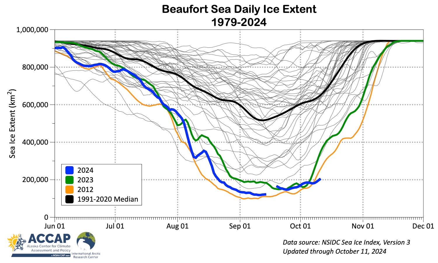
Following (and contributing to) the slow Arctic-wide sea ice increase are the Beaufort and Chukchi Seas, where new ice growth has also been limited. Daily ice extent for these seas are shown in Fig. 5.
Beaufort Sea ice extent is at record low for this late in the season, so there’s a lot of open water to freeze, and it’s now the time of year when sea ice extent often very rapidly increases. So far though, that is not happening.
In the Chukchi Sea, the 2024 minimum probably occurred during the four-day gap in the data, but in any case, ice extent is not showing much increase: the wiggles up and down in extent since data returned September 19 are largely the result of winds moving existing ice around, though in recent days, new ice is forming on the leading edge of the pack ice north of 75°N.
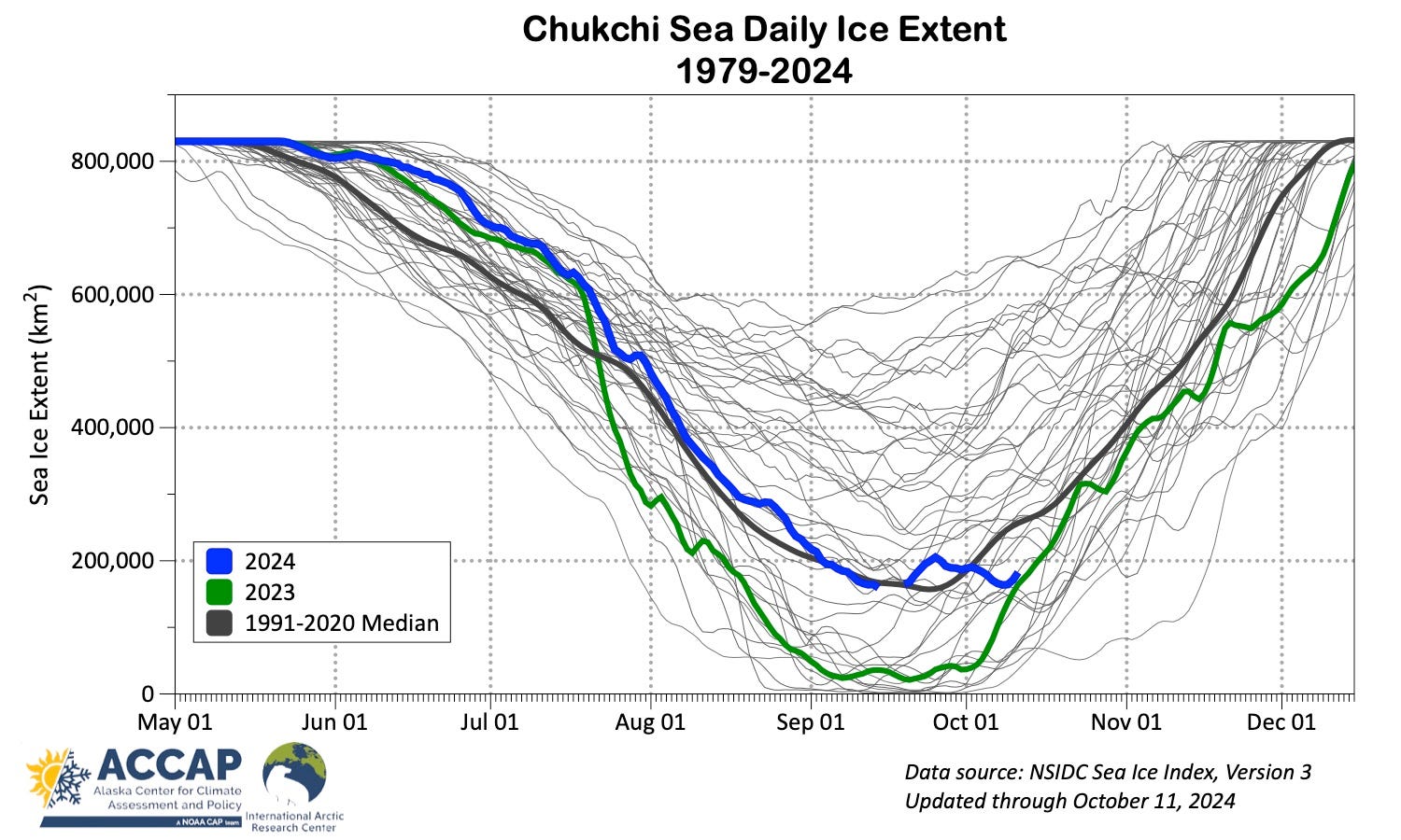
In the Chukchi Sea, there were only a couple of other years (1995 and 1997) when the October 11 ice extent was as close to the minimum as it was this year.
Sidenote
As Arctic subregions (including but not limited to the Chukchi and Beaufort Seas) have or will transition from ice dominated in the late summer and autumn to open-water dominated, this presents challenges with how to describe the modern seasonal evolution of sea ice coverage in relation to the past. This is worth some thought and a separate post.
Technical details and underlying data sources
AMSR2 data and images from the University of Bremen available here.
The NSIDC Sea Ice Index is based on the comparatively low resolution passive microwave data (nominal 25km² by 25km² but in practice is not that good) and given as the 5-day trailing average, so slightly lags changes in sea ice. At regional to Arctic-wide spatial scales this is usually not significant. Details on the Sea Ice Index are here. The regional daily data is available as an Excel spreadsheet here.
Modeled sea ice thickness and volume from the Danish Meteorological Institute is available here.
September 1995 was exceptionally mild (for the era) almost everywhere in the Arctic, and was the mildest September from 1940 up to that time. From today’s perspective, every September since 2004 has been milder than 1995.
Thanks for your (as ever) thought-provoking, well-written and -illustrated newsletter, Rick. The footnote for this issue:
"September 1995 was exceptionally mild (for the era) almost everywhere in the Arctic, and was the mildest September from 1940 up to that time. From today’s perspective, every September since 2004 has been milder than 1995."
in one we'll use in the OneTree STEAM Studio for the next few months when visitors look at the spring phenology calendars. It's great to have the flip side of the year represented by your text and graphics and your 'outlook' or capsule comment (or?) "Slow start to the sea-ice growing season" for people to chew on. Helps us all to consider degree-days and various growing seasons. Many thanks.
Thank you, Rick. This information is not good, but certainly unsurprising news. I wrote an article on the Greenland ice sheet recently. Siberia and the Arctic are on my mind, too.
https://geoffreydeihl.substack.com/p/the-greenland-ice-sheet-is-gone