


August 2024 Record Arctic Heat
Northern Alaska and Northwest Canada

****I posted update of this event here on August 12, 2024.***
For the second summer in a row, extreme, all-time record heat has baked parts of northwest Canada and Alaska. In 2023, the July 8-9 heatwave was centered in the middle and upper Mackenzie River valley and central and southern Yukon Territory, with the Alaska-Yukon borderlands and northern Southeast Alaska on the edge (for details see my post here).
How hot was it?
Figure 1 plots the highest reported temperatures August 5-7, 2024. The most extreme heat relative to the climatology occurred north of the Brooks Range and east of the Richardson Mountains. South of the Brooks Range there were a few daily records. Most notably, the high temperature of 87F (30.6C) at Northway (southeast of Tok) on August 6 is the highest temperature so late in the summer.
Alaska North Slope
Temperatures peaked on the central and eastern Alaska Beaufort Sea coast on August 6. Climate observations have been made in the Deadhorse/Prudhoe Bay area since December 1968, and the high temperature of 89F (31.7C) is by far the highest temperature in that time, breaking the previous record of 85F (29.4C) on July 13, 2016. This is the second the August in a row with extreme heat in this area: on August 5, 2023, Deadhorse reached 84F (28.9C), which was, as it turned out, a short-lived monthly record high temperature.
The lower Mackenzie River valley
The high temperature on August 7 of 34.8C (95F) at Inuvik is also easily the highest temperature on record. The previous record was (apparently) 33.0C (91F) set July 4, 2023. At Tuktoyaktuk, on the shore of the Beaufort Sea, the high temperature August 7 of 29.9C (86F) was not an all-time record (30.4C, 87F in July 1998) but is a new August record high. The highest temperatures at Ft. McPherson and Little Chicago, NWT are higher in this event than in 2023, but from Ft. Good Hope southward, 2023 had higher temperatures (at least through August 7).
Overnight low temperatures
In some areas overnight temperatures were also exceptionally high. Hillsides around Fairbanks saw temperatures remain above 60F (16C) August 6 and 7. Continuous strong south winds at Delta Junction/Fort Greely (between Fairbanks and Tok) from the evening of August 5 through the early morning of August 8 kept temperatures elevated day and night. The result was the low temperature on August 6 was only 71F (21.7C), which is not only the highest minimum daily temperature on record at Delta Junction/Fort Greely (previous record 70F/21.1C August 4, 1999) but may well be the highest daily minimum temperature anywhere in Alaska.1
Why so hot?
The mid-atmosphere pattern supporting this heatwave (Fig. 2 ) is a classic pattern for extreme warmth in the summer in northwest North America, with big warm high pressure aloft centered over the southern Yukon Territory and strong low pressure anchored over the Bering Sea (if you click on the image it should be bigger).
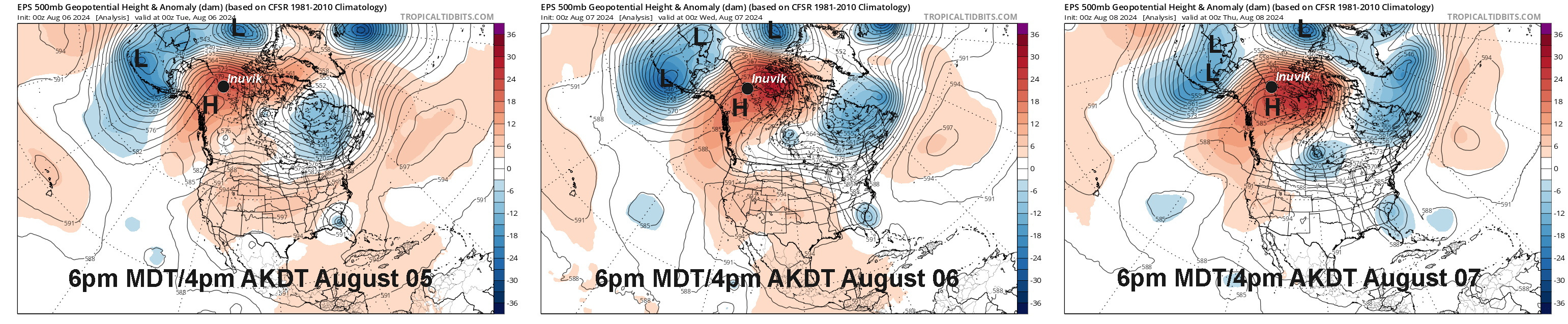
To the west of the high center, strong south winds from the Gulf of Alaska all the way into the Beaufort Sea served to increase the temperature the airmass through latent heat release caused by water vapor being precipitated out on the south slopes of the coastal mountains and Alaska Range and then warming as the air descends on the north side of the mountains.
NOTE: As of August 8th the heatwave is ongoing in the Northwest Territories. But the magnitude of the heat warrants an interim post. I’ll have a final recap when more seasonable weather returns.
Technical details:
Ogimet is an excellent online resource for near-real time Canadian (and most other countries) daily climate observations.
High frequency temperature data direct from Environment and Climate Change Canada for the Northwest Territories here and for the Yukon Territory here.
Canadian climate normals and extremes available here.
Alaska data mostly pulled from the xmACIS website.
There are many climate observations in Alaska with clearly spurious daily low temperatures higher than 70F. There have been a few reliably reported occurrences of slighter overnight low temperatures, e.g. Delta Junction July 30, 2009, but not for midnight to midnight. Thanks to B. Brettschneider for trolling through the hot mess of high-end low temperatures.
It seems like in recent summers Arctic Russia was getting those extreme warm temperatures, and I allowed myself to think (knowing I was wrong), "wow, at least it doesn't get that bad in Alaska, must be something special about us!" How has Arctic Russia fared this summer? Haven't heard much this year.
Also, it seems like we had some pretty high dewpoints during some of this, yet they seemed to vary by up to 10F in a matter of hours. Maybe a function of the presence or lack of presence of the chinook winds? Wouldn't the high dewpoints alone (low 60's) account for the elevated night time temperatures?
Just thinking out loud here...
Rick, as I said, get beachfront property (at least 20 meters above current sea level) while the Canadians are still encouraging immigration up there. But warning, it's a long way to a 7-Eleven when you want a Slurpee! And bring a lot of polar bear spray!