July 7 and 8, 2023 brought a short lived but extreme heatwave to northwest Canada and adjacent areas in Alaska. This comes on the heels of the July 3-4 heatwave that produced record high temperatures near the Beaufort Sea coast in the Yukon and NWT. In some ways this event was reminiscent of the June 2020 heatwave in Siberia when Verkhoyansk reached 38.0C (100F) to set a world record for highest temperature north of Arctic Circle. Here’s a short summary.1
How Hot was It?
On July 8th, Norman Wells, NWT, at 65.3N in the Sahtu region, reported the highest reliable temperature of the heatwave, reaching 37.9C (100F), while to the northwest, Fort Good Hope hit 37.4C (99F). These extreme temperatures were occurring at the same time the areas was blanketed in wildfire smoke, which at Norman Wells reduced visualities to less than 2km (1.5 miles) much of the day. From the climate perspective, these are evidently the highest temperature on record this far north in Canada. Norman Wells is a low elevation site with Mackenzie mountains to the west so it can get unexpectedly warm there. In July 1989 the Norman Wells airport reported a high temperature of 35.0C (95F). The Northwest Territories record high temperature remains 39.9C (104F) set at Fort Smith on June 30, 2021.
In the Yukon Territory, the high temperature of 35.5C (96F) at Carmacks on July 7th was 1C from the YT all-time record high temperature of 36.5C (98F) at Takhini in June 2004.
In Alaska, on July 7 temperatures reached 32.8C (91F) at Eagle and, 400 miles to southeast, at the NWS cooperative station at the US Customs Station on the Haines Highway. Perhaps more remarkable was the high temperature of 32.2C (90F) at the Snettisham Power Plant cooperative station southeast of Juneau. At Northway, the high temperature of 31.1C (88F) tied the all time July record high first set in 1955.

When comparing these temperatures it’s important to keep in mind that much of the Yukon Territory is an elevated plateau while the Mackenzie River communities are much lower elevation. For example, Whitehorse Airport is at 700 meters (2300 feet) MSL, while Norman Wells is at 74 meters (240 feet) MSL. This makes temperatures in the the Yukon even more remarkable. For example, if you took the air that produced a temperature of 35.5C at Carmacks down to the elevation of Norman Wells it would (hypothetically) be close to 40C.2
Why was it so Hot?
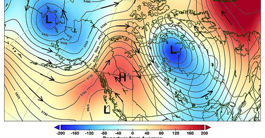
The mid-atmosphere pattern is definitely one we expect to produce hot weather in the summer in northwest North America. Figure 2 shows the average mid-atmosphere (technical: 500 hPa) pressure (technical: geopotential heights), departures from average and wind direction for July 8. High pressure aloft centered over northernmost British Columbia brought southwest winds across the St. Elias mountains helped maximum airmass warmth. But to be frank, I would not have thought this pattern to be associated all-time record high temperatures: I would have expected higher heights for that. It would be interesting to see an attribution study to help understand to what extent anthropogenic-forced climate change contributed to this event.

I am conversant with online Canadian weather and climate sources and know the climate of Arctic and sub-Arctic regions but I have no particular expertise on the vagaries of individual weather stations in the Yukon or NWT. All of the specific details should be considered preliminary and subject to revision.
Carmacks is at 540 meters MSL, so a dry adiabatic lapse rate down to 74 meters would add more than 4C to the temperature. Obviously, in the real world additional factors are at play.


Does the wildland fire smoke increase or decrease the surface temps? During persistent Fbks smoke events it seemed the smoke blocked some of the solar heating.