


April 2023 Alaska and Arctic Climate Review
Spring Delayed

The sun returns but from northeast Russia across Alaska into the Yukon Territory, winter held on in April.
Temperatures
April in the Arctic was a month of notable contrasts temperature-wise, with the largest departures in North America. Figure 1 shows average temperature departure departures from the 1991-2020 baseline normal. In Canada, portions of the Northwest Territories and Nunavut were well above normal. This warmth extended eastward across Greenland to the Barents Sea region. In contrast, much lower than normal temperatures occurred over northern and western Alaska and more modestly below normal temperatures were found over most of the Pacific side of the Arctic Ocean, in western Siberia and the Canadian high Arctic islands. Based on this reanalysis, the April average temperature for the Arctic as a whole (poleward of 60°N) was 0.28°C (0.50°F) below the 1991-2020 average, making this the coldest April since 2009.

Taking a closer look at the greater Alaska region, I’ve previously written about the early April extended historic cold in western Alaska and the eastern Interior late April cold outbreak, so here I’ll review the monthly highlights. At the station level (Fig. 2) we find monthly temperature departures of 10 to 14 degrees below normal over a wide swath from the central North Slope coast southwest to the Yukon-Kuskokwim Delta and south into the Central Interior. Remarkably, at some places in western Alaska, April had a lower average temperature than March, including Nome (10.0F in March, 8.4F in April) and Bethel (18.6F in March, 17.0F in April). However, for places with long term climate observations, no place had the coldest April on record, as 2013 in the eastern Interior and especially 1985 in the western Interior and western Alaska were colder. At Tanana though, the last time there was an April colder than this year was in 1924.
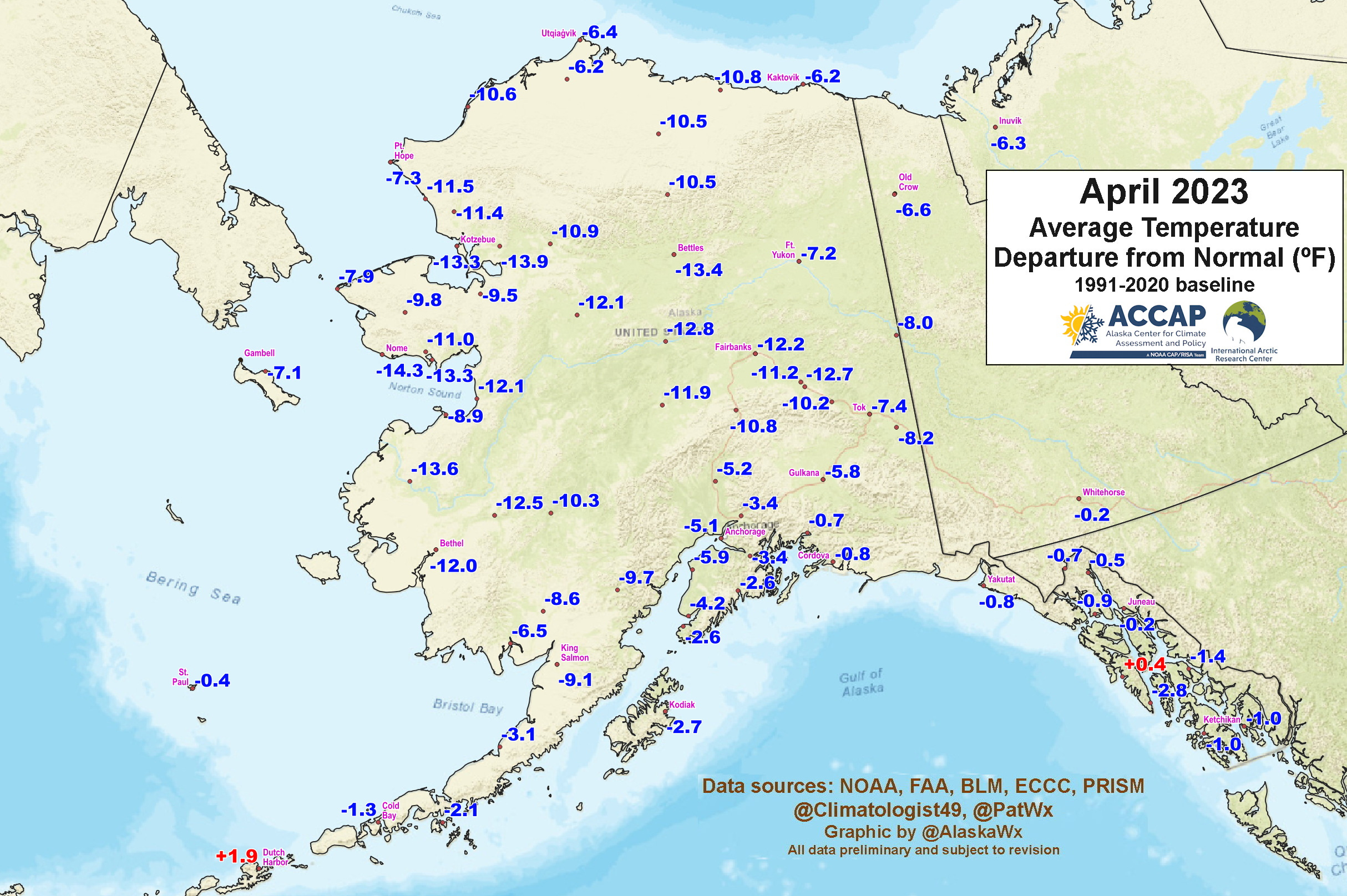
Figure 3 shows the April temperature departures normal (°F) from ERA5. I’ve also added hatching to highlight areas where the average temperature in April was low enough to rank in the top three coldest since 1973 (in this reanalysis model). In addition to portions of the Seward Peninsula and Northwest Arctic Borough, the “top three coldest” area includes much of the central Interior and the central Brooks Range. In a small area north and northwest of Bettles April 2023 ranks as the coldest in the past 50 years.

Precipitation and Snowfall
Precipitation in April showed a general west to east split across the region, as seen in Fig. 4. West of about 150°W, totals were generally below the already seasonally low normals, while east of 150°W totals were mostly above normal, and this included all of the Yukon Territory and northwest British Columbia. At the station level there were no observations at or near record levels. Little Port Walter (Baranof Island, Southeast Alaska) had the highest reported total in the state with 20.49 inches (520.0mm) of rain and a little melted snow. One area with persistent low precipitation recently has been the southern Kenai Peninsula and Kodiak Island areas. Here precipitation was below normal in February and March too, and the February through April precipitation total at Kodiak was only 42 percent of normal, the lowest early spring total since 1972.

April snowfall was generally not heavy but was above normal in most areas mainland Alaska areas away from the coast from about Anchorage eastward. Anchorage Airport’s 10.0 inches of snow was more than twice normal and the highest April total since 2013. At Fairbanks, the April total of 8.6 inches was also more than twice normal. The highest reported snowfall was in the middle Susitna Valley between Huston and Trapper Creek: 18 to 24 inches of snow fell in this area April 11-12th and some Mat-Su Borough schools were closed because of the snow. The CoCoRaHS volunteer observer near the junction of the Parks Highway and Talkeetna Spur Road reported a monthly snow total of 36.6 inches (93.0cm), the highest in the state in April.
Snowpack was very slow to melt over much of mainland Alaska and in some places was near report high levels late in the month. At Anchorage Airport, the winter snowpack melted out April 30th, the fifth latest loss of the winter snowpack in the past 71 years and latest since 2013. I’ll have a more thorough snowpack post once the low elevation snowpack melt is nearly complete.
Sea Ice
The very cold and generally “unstormy” weather in the northern Bering region led to an increase in the sea ice extent in early April (Fig. 5, left), and the extent was very close to the 1991-2020 median during the second half of the month. The NWS Alaska Region April 30th sea ice concentration analysis (Fig 5, right) showed the ice edge fairly far south in the central Bering Sea but with large areas of open water or low concentration ice well to north. There were also areas of lower concentration ice along the Chukchi Sea coast between Cape Lisburne and Utqiaġvik. All these features are typical for this time of year.

Wow, an April average lower than March for Alaska seems very strange, especially with the large increase in daylight hours. It seems that California is following a season very similar to Alaska this year. The large-scale atmospheric waves have been stuck in a pattern with cold in both places.