


Alaska Snow Season Trends
The Snow Cover Season is Becoming Shorter

In a previous Alaska and Arctic Climate newsletter we looked a changes in snowfall amounts at the seasonal and annual timescales for Alaska and vicinity. Today we’ll use a newly published dataset to look at changes in the length of the snow cover season. The “Bioclimatic atlas of the terrestrial arctic” by Mika Rantanen and co-authors1 was published in January 2023 in Scientific Data, a peer-reviewed, open-access journal for descriptions of datasets. The authors have processed the very high resolution (hourly at 10km x 10km horizontal grid) ERA5 Land dataset to create 18 new climate variables of particular interest at higher latitudes. Here I’ll use three related snow cover parameters:
Snow season length (SSL). The length of the snow season (SSL) is defined as the longest continuous period of the year when the grid cell is snow-covered (i.e., the daily averaged snow cover fraction is 0.5 or greater).
Onset of snow season (SSO). The onset of the snow season (SSO) indicates the first day of the snow season, as defined by the variable SSL.
End of snow season (SSE). Similarly as SSO, the end of the snow season (SSE) indicates the day of the year when snow season ends, as defined by the variable SSL.
A couple of things to note: snow cover in this dataset is binary: either yes or no, and refers only to the fractional coverage and nothing about the amount of snow. In reality of course, 100 km² grid cells will sometimes contain large variations in snow cover, especially in complex terrain. For example, in early May in Interior Alaska, one grid cell could easily include large areas with no snow at all remaining, e.g. south facing hillsides and north facing higher elevations that still have a deep, continuous snow cover.
With those caveats in mind, let’s take a look the trends. As is my preference, trends here are expressed as total change over the time involved (71 years in this case).
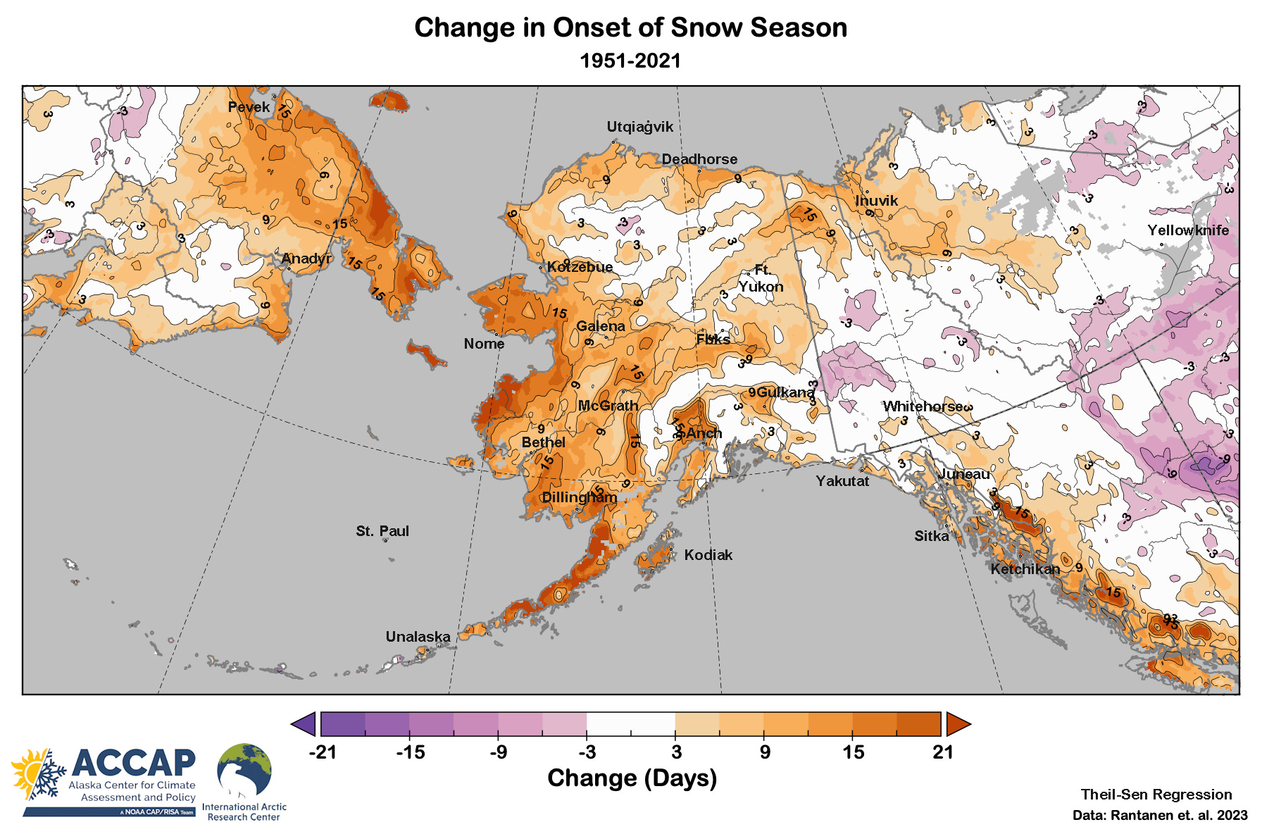
Figure 1. shows the change (in days) of the snow season onset, e.g. when the winter snowpack is established, between the 1950-51 and 2020-21 seasons. For most of Alaska the snowpack is nowadays established significantly later in the auutmn than 70 years ago, though some low elevations on the inland North Slope and northern Interior show little change. The largest changes are in western Alaska and in the lower Susina valley in Southcentral. These are areas that also show large decreases in autumn snowfall (amount). In the Yukon Territory the only area with significantly later snowpack establishment is in the north, with some areas in the central YT showing a weak (not significant) trend to earlier snowpack establishment.
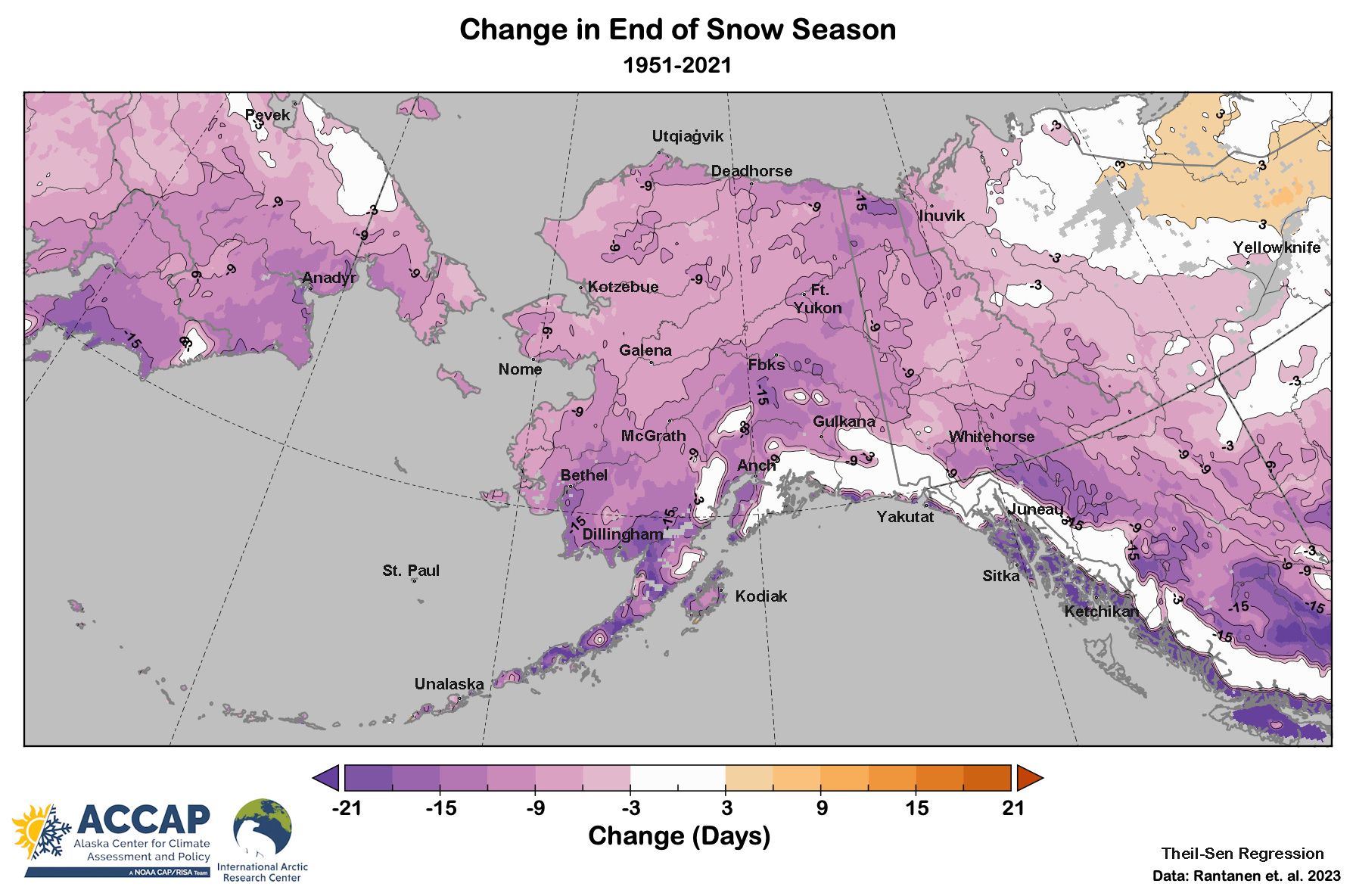
In the spring the change is larger than in the autumn from the central Interior eastward through the Yukon Territory, but not as large in western Alaska, as shown in Fig 2. Nonetheless, the end of snow cover season is trending earlier everywhere in Alaska and the Yukon Territory except for the high mountain and glacier areas. In southwest Alaska and the southern Interior the changes are very dramatic: one to two weeks earlier. An earlier start to the “bare ground” season has the potential for significant impacts to ecosystem as the lands starts to dry out sooner, which in turn has implications for wildfire in the North.
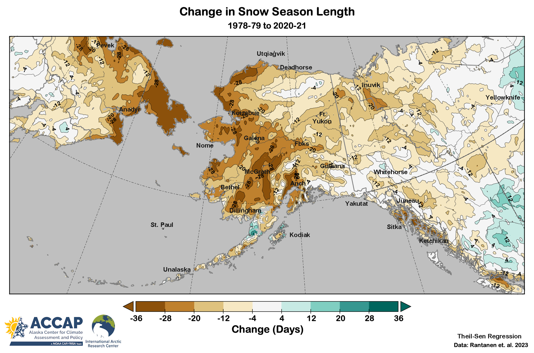
Putting the autumn and spring changes together gives us the total change in the length of snow cover season, and this is shown in Fig. 3. I’ve a used a different color scheme here to highlight the larger scale. Since in most areas the snow cover season season is shrinking at both ends, some of the changes are really extreme, e.g. more than four week decrease in parts of western and southcentral Alaska.

Now a question we routinely ask when using climate reanalysis data is: are there potentially artificial changes introduced with the incorporation of satellite data into the reanalysis starting in 1979? To address this question I’ve extracted the annual values for snow season length since 1978-79 and then recalculated the trend using the same methodology as used by the authors for the full 71 year record, and this is shown in Fig. 4. It’s immediately apparent that the basic pattern over Chukotka, Alaska and the Yukon Territory is the same. There are a few, mostly small exceptions, e.g. increases in snow season length on the upper Alaska Peninsula, a slight increase near Whitehorse, YT and in small areas in the Russian Far East. This suggests that at regional scale the lack of satellite data pre-1979 is not artificially influencing the trends, though at small scales there may (though not necessarily) be some effect.
In summary, this new dataset helps us overcome the lack of long term, in situ snow cover observations and allows us to make a quantitive estimate of the change in this critical component of high latitude climate.
Rantanen, M., Kämäräinen, M., Niittynen, P., Phoenix, G.K., Lenoir, J., Maclean, I., Luoto, M. and Aalto, J., 2023. Bioclimatic atlas of the terrestrial Arctic. Scientific Data, 10(1), p.40.
Super interesting, thanks for writing and sharing!
Thank you for all of this work, but the data just makes me sad...