


Alaska July Climate Updates
Important happenings here too

With high impact extreme weather occuring all around the world in recent week and a fragmented social media ecosystem, here’s a quick post on some recent recent Alaska weather and climate highlights that you may have missed.
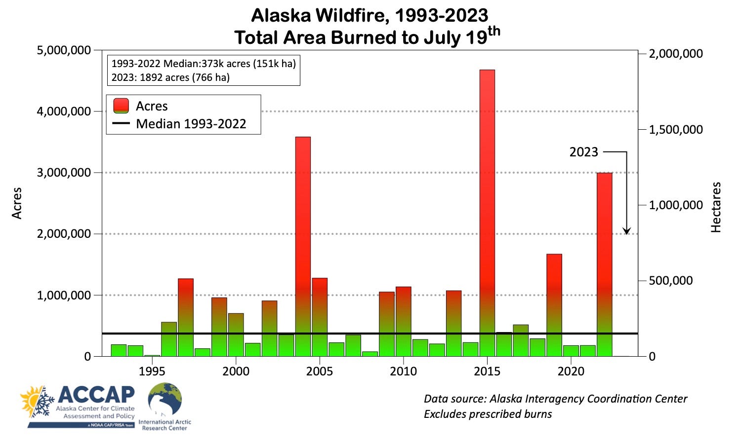
Whither the Wildfire
Wildfire remains minimal in Alaska. Amazingly, less than 2000 acres (800 ha) has burned so far this season, less than 1 percent of the 1993-2022 median to this point in the season. It’s likely that Alaska has not seen this little wildfire to this point in the season since the 1960s and possibly not since the 1940s. Typically about 70 percent of the total acreage that burns each season has burned by mid-July, but this year is such an outlier that we’ll do well to heed that old saying: “it’s not over til it’s over”. With hot and dry weather coming to the Interior, it’s likely that we’ll see an uptick in fire activity, though without active fires the source of ignition is most likely to be human activity since thunderstorms will be few and far between.
To the east of Alaska, wildfire has increased in the Yukon Territory and is now not far from average. In the Northwest Terrtiores, this year is already the largest wildfire season since 2014.
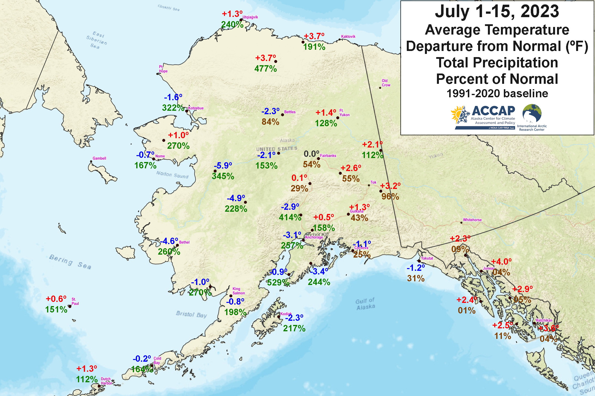
Unusual Start to July
The first half of July showed a remarkable split in temperatures and rainfall across the state. Southeast Alaska and the southeast mainland was quite dry and generally warmer than normal, while Southwest and much of southcentral Alaska was cool, cloudy and wet. The North Slope saw warm and wet conditions. All of this was the reflection of a persistent weather pattern, with low pressure in southeast Bering Sea and south to southeast winds aloft.
Rainfall at Homer Airport totaled 3.12 inches (79.2mm) the first 15 days of July, was the highest of any July 1-15 on record. At Talkeetna 5.05 inches (128.3mm) was the highest since 1981 and the third highest on record. In stark contrast, Sitka rainfall of 0.02 inches (0.5mm) was just 1 percent of normal and the second lowest on record, with only 2019 having less rain the first half of July. For more details on July 7-8th short but intense heat from Alaska near the Yukon border into northwest Canada, see my post here.
Northern Warmth
On July 19th at Utqiaġvik, following an overnight low of 53F (11.7C) the temperature at the Airport peaked at 74F (23.3C). This is highest temperature at Alaska’s northernmost community since July 14, 2009, when the temperature also reached 74F. In the past 103 years at Utqiaġvik there have only been six days with a higher tempertaure, most recently in July 1999. The low temperature of 53F (11.7C) is a new July record for daily highest minimum temperature (the previous record was 51F, 10.6C on July 22, 2019) and ties the all-time record set on August 25, 1979 and tied August 13, 2005. Finally, the daily average temperature1 of 63.5F (17.5C) ties for the highest daily average tempertaure on record Utqiaġvik, first set on July 13, 1993, when the high temperature was 79F (26.1C) and low was 48F (8.9C).
Figure 3 shows high temperature across the central and western North Slope on July 19. Temperatures away from the coast are warm, but not extreme. Because Utqiaġvik is located on a peninsula, especially high temperatures in the summer, like really low temperatures in the winter, are strongly dependent on having a land breeze, i.e. a wind blowing from the southeast to due south, and this is what happened on the 19th: southeast winds all day. Any other direction and the air is blowing from either the Chukchi Sea (southwest through north winds) or Elson Lagoon, the body of water between the coast and the barrier island just east of Point Barrow (northeast to east winds).

By long standing climate convention, the daily average temperature is simply the average of the high and low temperatures.