2023 Sea Ice Minimums Near Alaska
Lowest in Years

I previously posted about the 2023 Arctic-wide sea ice minimum here. This post focuses on the seasonal minimum ice extent in the Chukchi and Beaufort Seas north of Alaska.
Overveiw
Sea ice near Alaska reached its minimum extent on September 20th. The combined ice extent in the Chukchi and Beaufort seas dipped below 200,000 km² for only the second year in the 45-year satellite era (and probably for much longer than that), with only 2012 having lower extent, as is evident in Fig. 1. Ice extent was near average for the two combined sea through mid-July, when above average extent in the Chukchi Sea offset below normal extent in the Beaufort Sea. Thereafter extent dropped dramatically, and remained second low from late August through most of September.
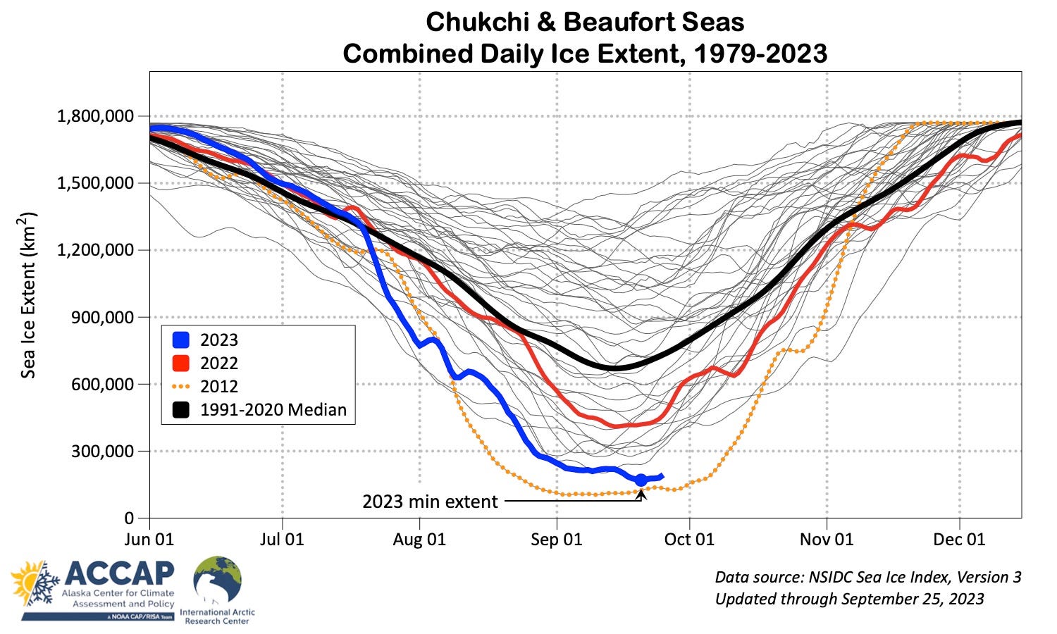
Figure 2 shows the National Weather Service sea ice concentration analysis for September 23, 2023 and I’ve annotated distances from a few communities to the nearest significantly ice. The low concentration ice just northwest of Kolyuchin Bay, on the north Chukotka coast 320 miles west-northwest of Kotzebue is part of an area of low concentration ice that has persisted all summer and kept sea surface temperatures well below normal in the far western Chukchi Sea. The long distances to ice means that any strong storms that come along in the next several weeks have the potential produce high seas due to extremely long fetch across open water.
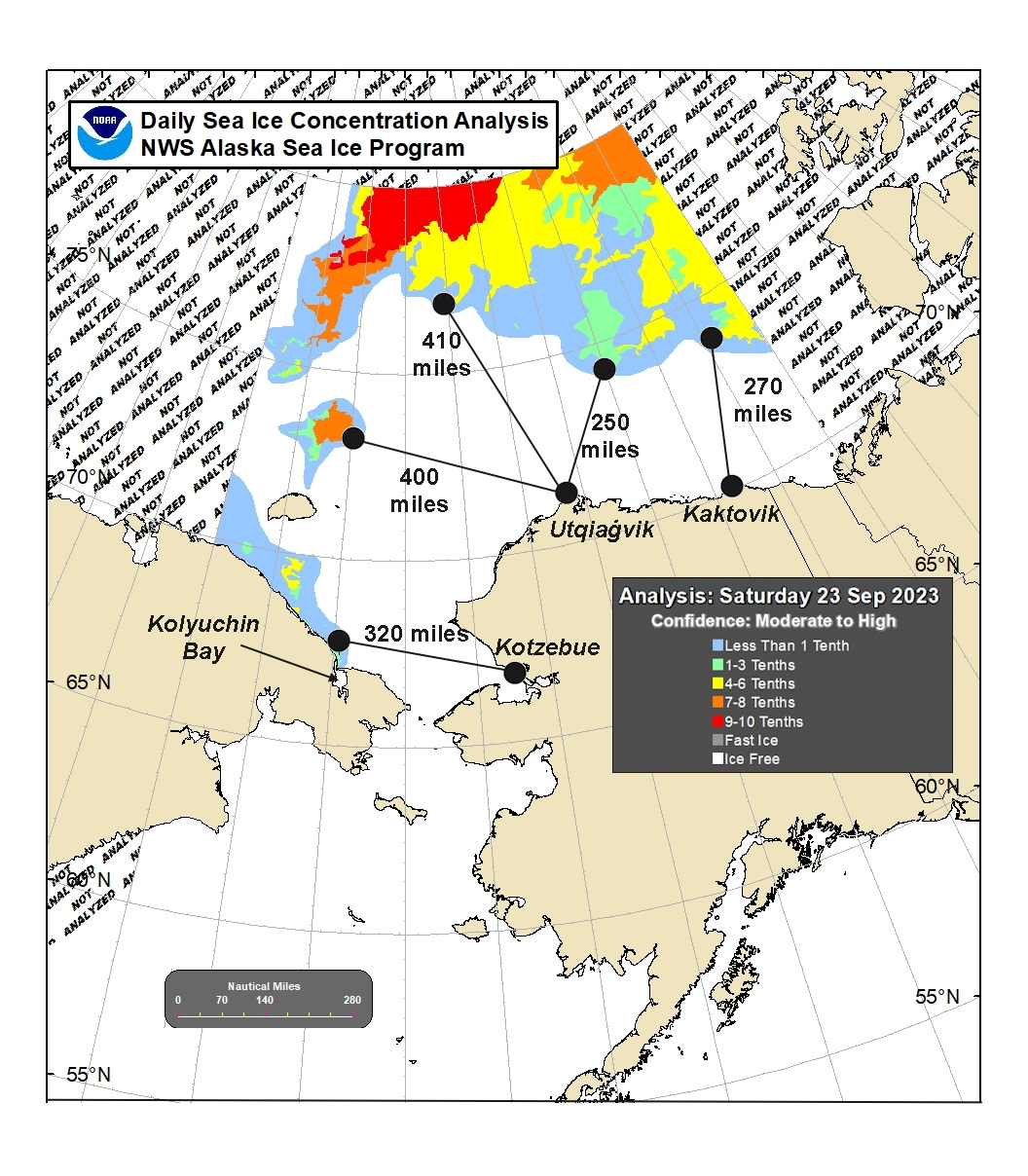
Although these distances to ice are remarkable in the 20th century context, they have been exceeded in some recent years. For example, in mid-September 2019, the nearest significant ice northwest of Utqiaġvik was about 500 miles (800km) away, and in mid-September 2016, the ice pack edge was about 350 miles north of Kaktovik.
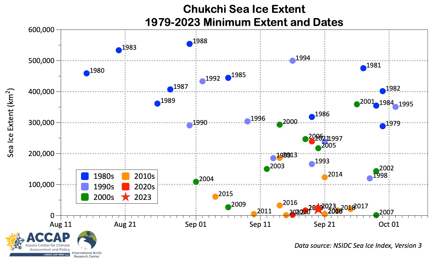
Chukchi Sea
The minimum ice extent in the Chukchi Sea finished as tenth lowest in the past 45 years (all ten of the lowest have occurred since 2007). However, that rank is not very meaningful. NSIDC uses a definition of the Chukchi Sea that extents to about 78°N, nearly 500 miles (800km) north of Utqiaġvik, and it’s near the northern boundary that most of the remaining ice was located in mid-September. Figure 3 plots the annual minimum extent in the Chukchi Sea along with a estimate of the time-varying median, which shows a decrease in the minimum extent since the early 1980s of about 98 percent. The Chukchi Sea is close to joining the peripheral Arctic seas like the Bering Sea and Sea of Okhotsk, where sea ice is seasonally present but not a year-round feature
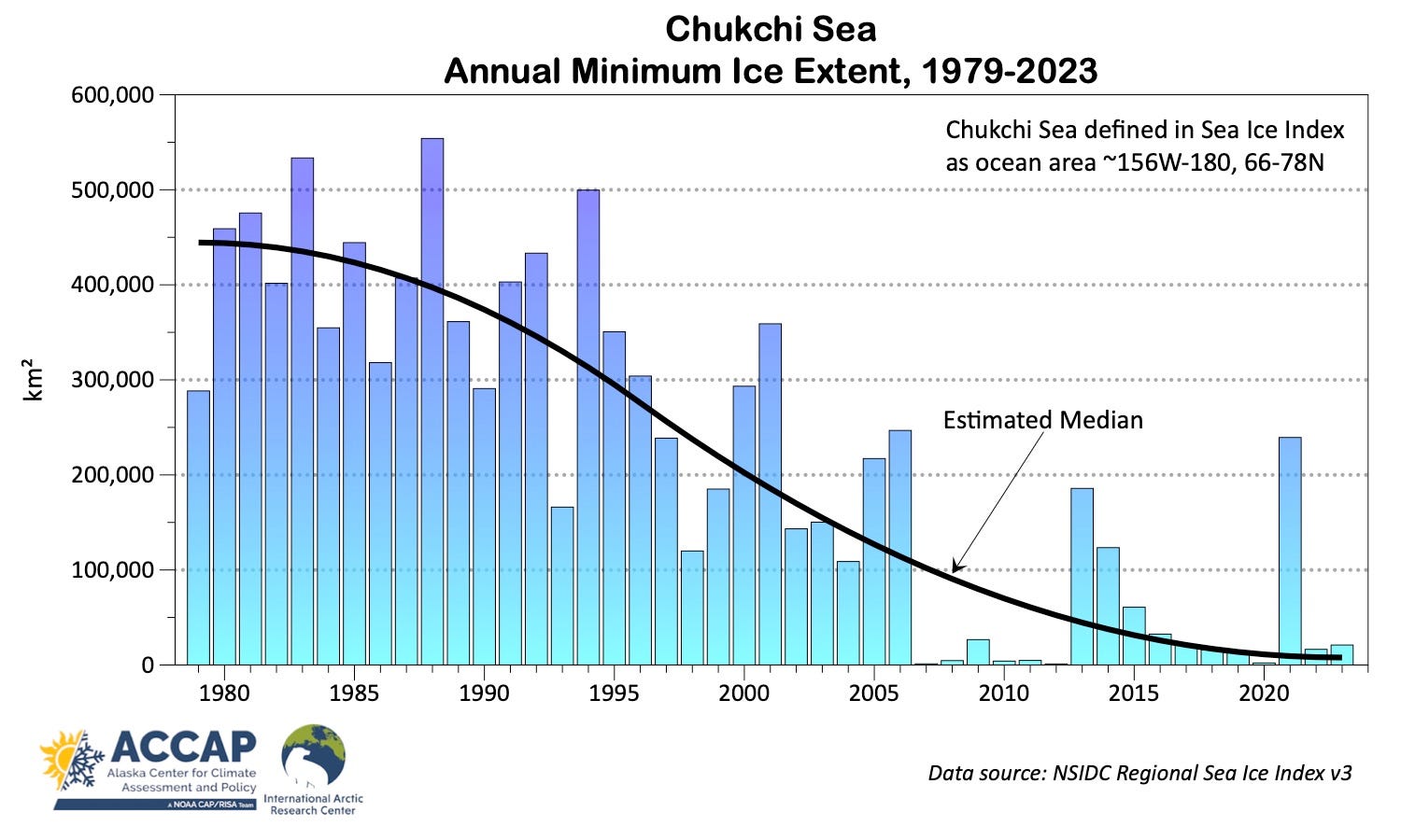
Figure 4 also plots the annual minimum extent but with the date of the minimum shown on the horizontal axis. There is no long term trend in the date of minimum but it does seem significant that 1) the minimum extent has not occurred in August since 1990 and 2) since 2007 there is much less variability in the minimum extent date. Since 2007 the standard deviation of the date is less than 7 days but 1979 to 2006 the standard deviation was 16 days.
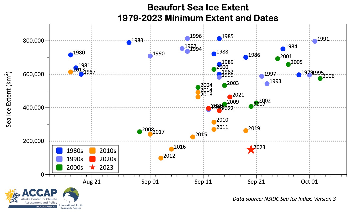
Beaufort Sea
Sea ice extent in the Beaufort Sea has been below average the entire melt season. This was perhaps not unexpected, as sea ice thickness near the end of the freeze season was well below the recent years average (see my post from late March here). However, record warmth across the eastern Beaufort Sea and adjacent land areas during the summer and a couple months of very warm water being discharged into the Southeast Beaufort Sea from the Mackenzie River surely played a role in pushing the ice extent much lower than in the past several year. Figure 5 shows the relatively late occurrence of the minimum extent this year, with the minimum extent just edging out 2016 for the second lowest in the satellite area.