


Winter 2024-25 Arctic Climate Review
Warmest winter yet, and wet too

Mid-winter (December through February) 2024-25 had the highest average temperature for the season for the Arctic since 2017-18 and edged out that winter for the mildest since 1950. Precipitation totals were also well above average, though not at record levels.
The Alaska climate review for February 2025 is here.
Temperature
Nearly all of the Arctic was warmer than average for winter 2024-25 (Fig. 1), with a whopping 94 percent of the Arctic (lands and seas poleward of 60°N) in ERA5 reanalysis having an average December through February temperature above 1991-2020 baseline normal. Only parts of Greenland were appreciably below normal, with the remainder of Greenland as well as Iceland and a portion of eastern Siberia about the only areas otherwise close to normal for the three-month average. This was the mildest winter since 1950 in parts of Nunavut and Nunavik, Canada, southwest Alaska and portions of Siberia. The Northwest Territories, Canada had the third highest winter average season temperature, Alaska the fourth and the Yukon Territory, Canada the fifth highest since 1950.

Average winter temperatures for the Arctic since 1949-50 are plotted in Fig. 2, and this winter edged out 2017-18 for the highest average temperature. Looking just at land areas north of 60°N, this was even more decidedly the mildest winter on record.
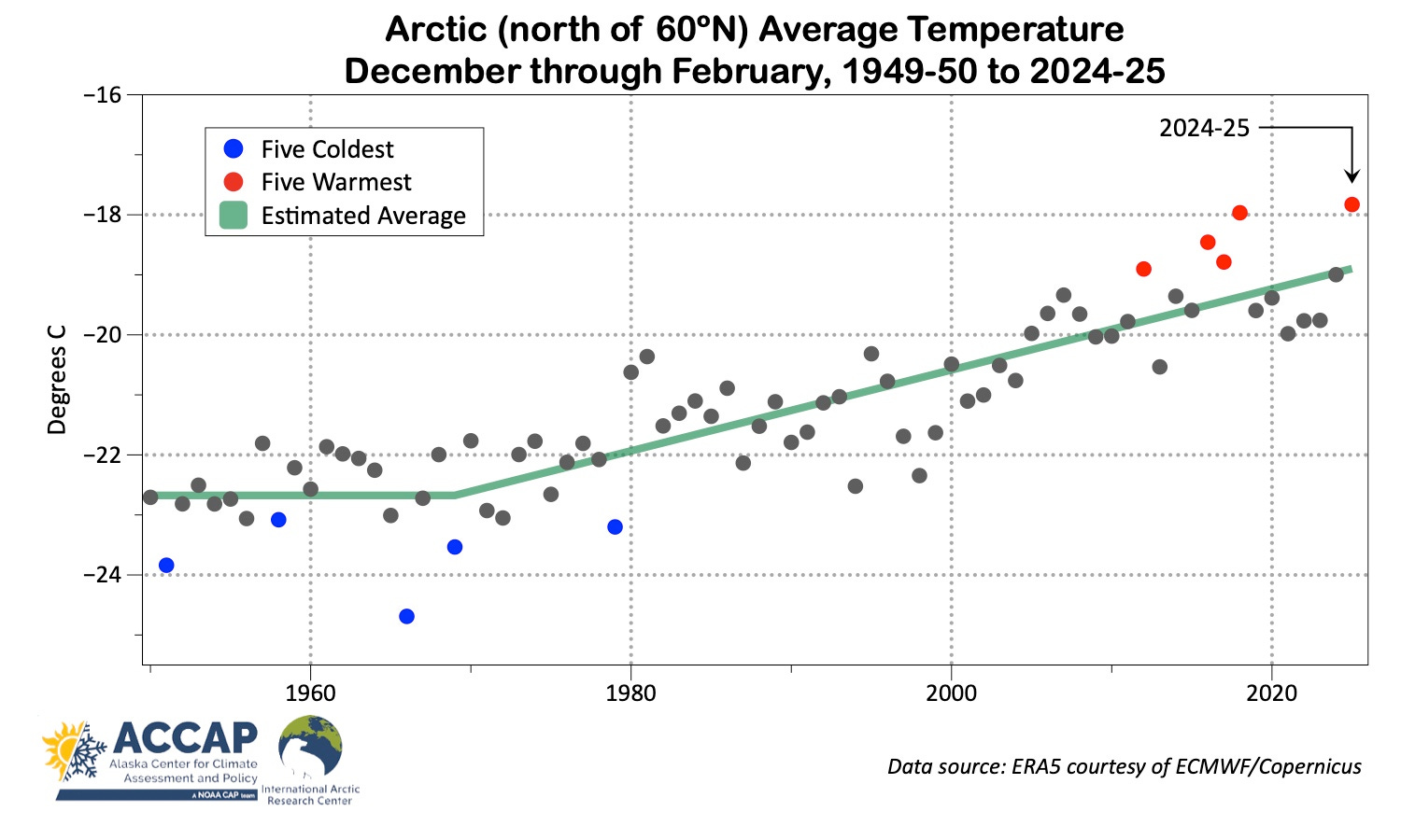
In addition to the dramatic increase in average temperature since the 1970s, note that every winter since 2013-14 has been milder than ANY winter was prior to 2004-05.
Precipitation
Total precipitation (water equivalent of snow plus rain) departures from the 1991-2020 average during the winter, were, as always, much more spatially variable than temperature. For the Arctic overall, this was the fifth highest December through February precipitation on record. Much of Alaska, western Siberia and the Canadian high Arctic saw especially high totals. Below normal totals occured in parts of northeast Canada and eastern Siberia.

Sea ice
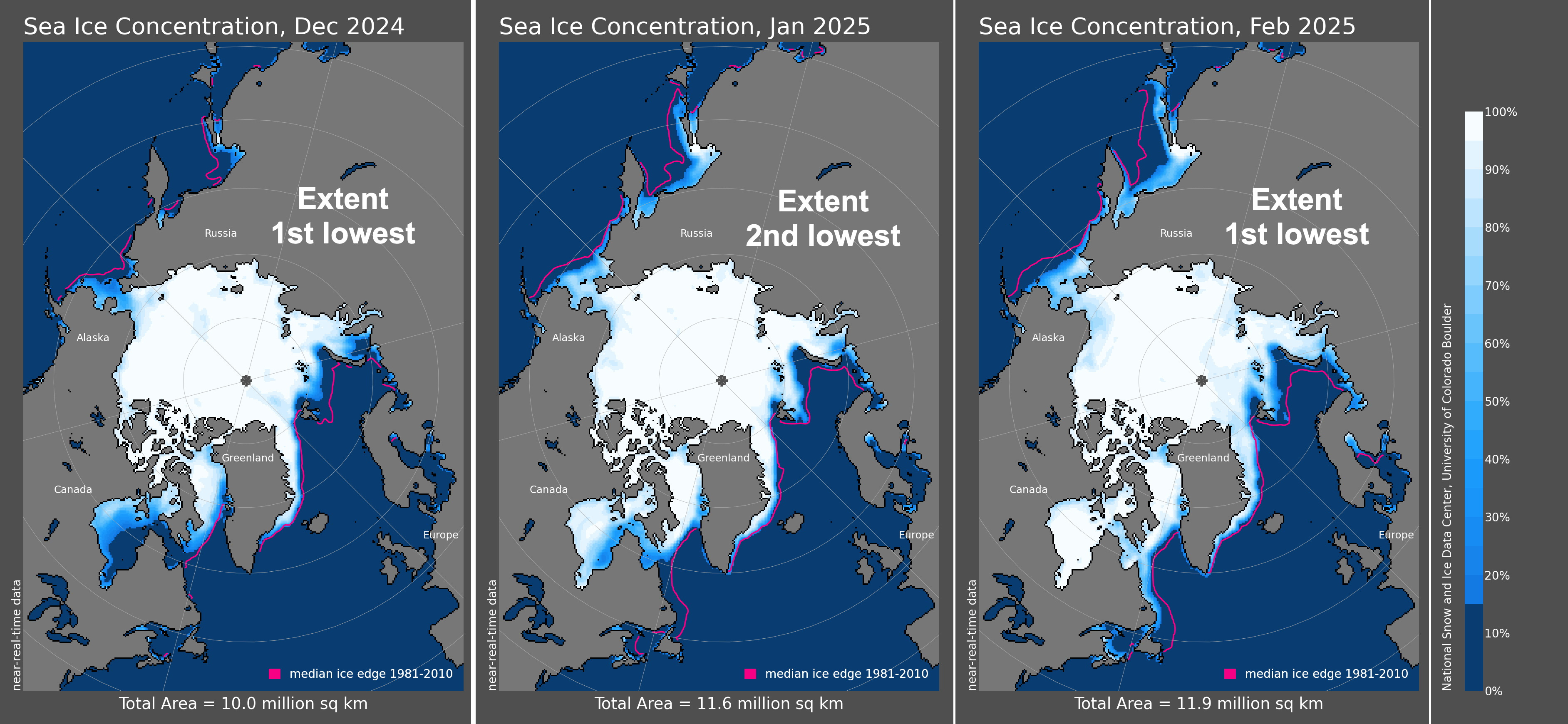
Following the slow increase in sea ice in Fall 2024, average ice extent in both December and February were the lowest of record, while January was second only to 2018 (Fig 4). Unlike some winters, the sea ice edge was significantly behind the 1981-2010 median on both the Atlantic and Pacific sides of the Arctic. As of February 28, there was about 1.6 million km² more open water in the northern hemisphere than was typical for the same date in the 1981-2010 period.
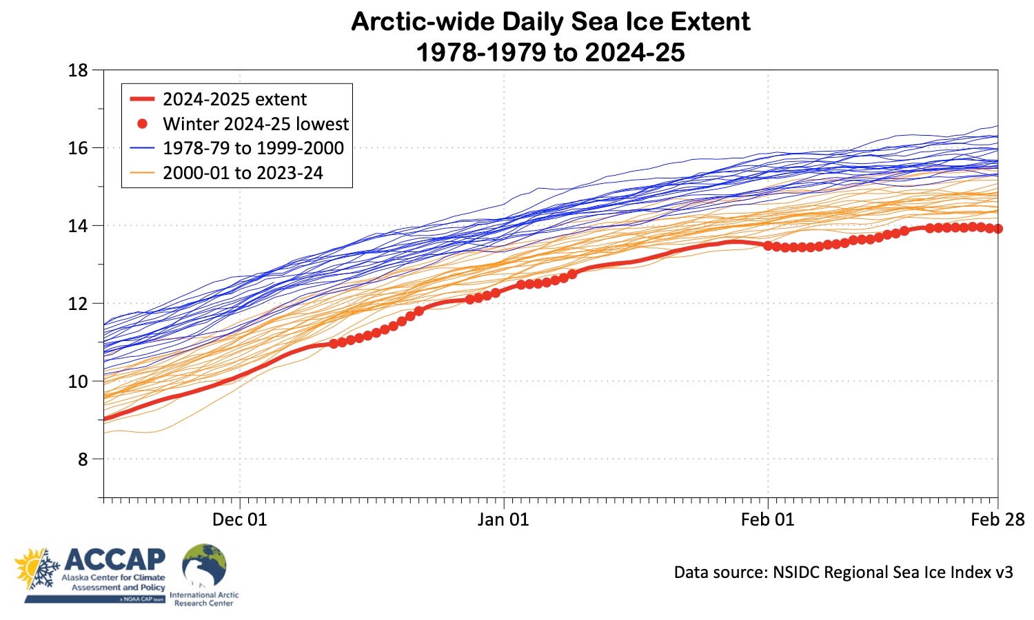
Daily Arctic-wide sea ice extent during the 2024-25 winter began to set new records lows based on NSIDC data the second week in December. Figure 5 shows the extent for all seasons since 1978-79 from mid-November to the end of February. This winter, more than half the days December through February were new record lows, including 26 of 28 days in February.
I know it's outside your remit Rick but is a similar warming going on in the south polar region 60° southward?
Thanks, Rick, for your sincere and downright scholarly efforts! I track C3S "Climate Pulse" and their other publications, including a recent post announcing a 0.4 degC GAST increase over the past 2 yrs. (1991-2020 baseline), so 1 full degC every 5 yrs at this rate (0.2 degC/yr.), 2 degC by 2027, 3 degC by 2032, and the extinction level 6 degC by 2047, the year any child born today among the 108,000 fellows will celebrate (?) his/her 22nd BD. I'm just crazy enough to wonder whether or not the seeming madness in DC is the billionaires realizing what's coming and attempting to raid the US Treasury before moving underground or rocketing off to Mars. Hmmmm?