


Spring has Sprung in Southeast Alaska

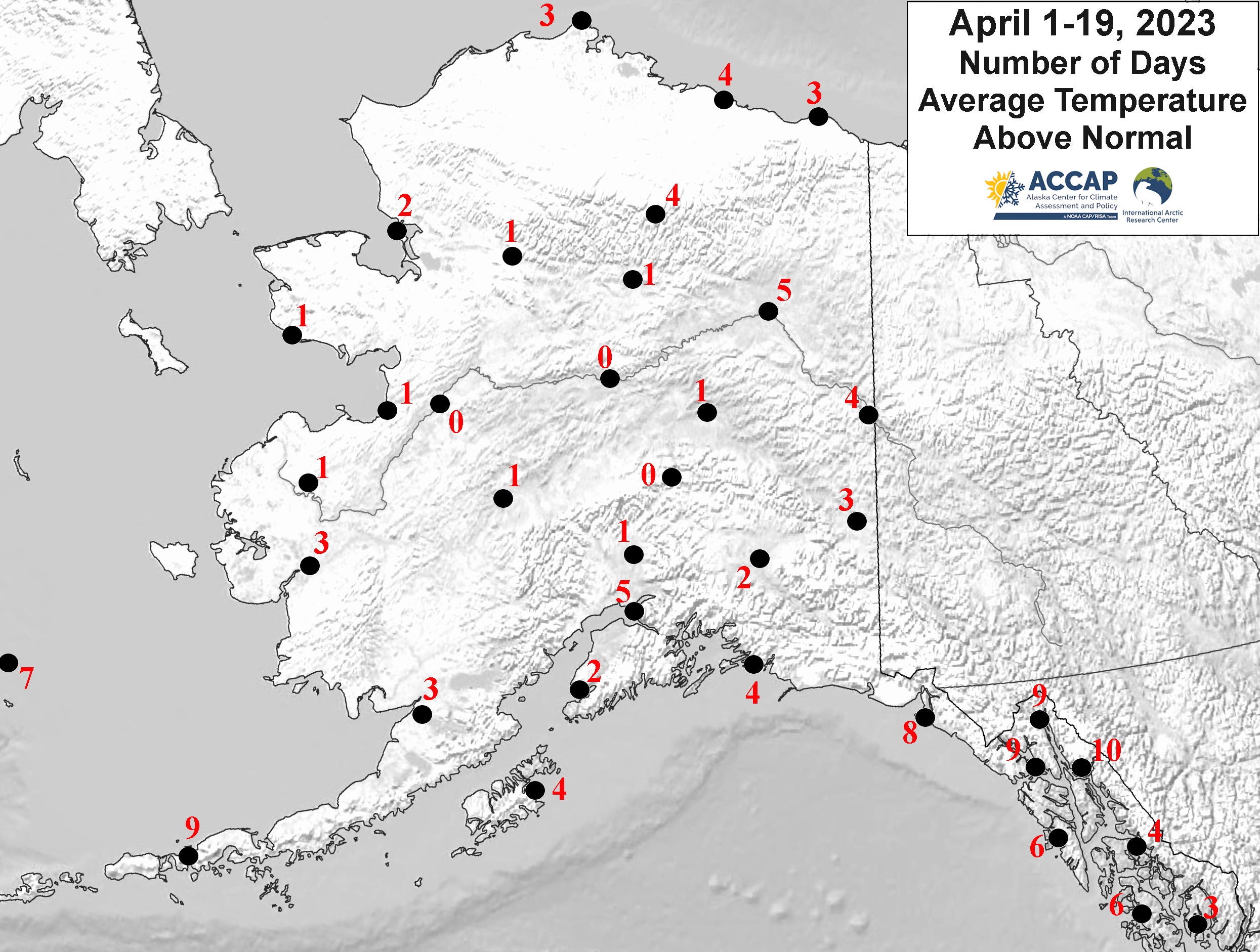
Much of mainland Alaska is chilling through one of the coldest Aprils on record with very deep snowpack remaining in parts of the Interior and western Alaska. However, Spring has come to Southeast Alaska, with temperatures close to normal this month. Low elevation snow melt is (nearly) complete except in some deep, protected fjords and temperatures have reached into the 50s on at least a day or two in most communities. On Tuesday April 18 Klawock Airport reported a high temperature of 57F as did Juneau Airport on Wednesday, and the Alaska DOT North Douglas weather station reported a high of 60F Wednesday afternoon, the first (unofficial) 60F of the season in Alaska. Figure 1 plots the number of days April 1 to 19 where the average daily temperature has been above normal. Northern Southeast and the eastern Gulf coast are clearly in a different class than most of mainland south of the Brooks Range.
It’s quite common for departures from normal of climate variables like average temperature or total precipitation at times scale from weeks to seasons to be quite different in Southeast Alaska compared to mainland Alaska. The reason for this is not primarily because of Southeast’s latitude, but rather the fact that the Panhandle is much farther east than mainland Alaska. For example, the difference in longitude between Anchorage and Juneau (~15°) is about the same as the difference in longitude as between Dallas and Phoenix and is greater than the difference between Philadelphia and Chicago (~13°). For those with long memories, you may recall that prior to the October 1983 time zone reorganization in Alaska, Southeast was on Pacific Time (same as most of BC, Washington, Oregon and California) while most of mainland Alaska was on Alaska Time, two hours behind Pacific Time. But why does this matter to climate?
It turns out that the typical scale the of dips and bulges in the jet stream as it circles the hemisphere are often (not always) about 35° of longitude dip-to-bulge, or vice versa. This means that Southeast Alaska is often in a different part of the large scale jet stream flow. While this month is not best example, it still illustrates the point. Figure 2 shows the average mid-atmosphere “pressure” and winds for the first 17 days of April across the region. The “cold ball” that brought the historic record cold earlier in the month to western Alaska shows up as anchored over Northwest Arctic Borough, with winds moving counter-clockwise around the low. Southeast Alaska is far enough away from that “cold ball” that winds aloft have been prevailingly out of the southwest, and the bulge in the jet stream is far enough east over Alberta that colder high pressure has remained too far east to impact Southeast.

Which brings up the question, Do time zone changes (that is, a station moving from one TZ to another, not the twice yearly nonsense) affect the station temperature statistics?