


Spring 2025 Arctic Climate Summary
Not quite as extreme as winter

Spring 2025 in the Arctic was not quite as extremely mild as winter (relative to past Springs) and sea ice extent saw some recovery after March. Regional variability in both temperatures and precipitation was higher in the Spring than during this past winter.
Temperature
The March through May average temperature is shown as the departure from the 1991-2020 baseline in Fig. 1. A large portion (81 percent) of the Arctic (land and sea poleward of 60°N) had a Spring average temperature above the 1991-2020 average, while 87 percent of Arctic lands were warmer than average. Iceland had the mildest spring since 1950 based on the ERA5 reanalysis, slightly warmer than 2004, while Norway had the second warmest spring: only last year was warmer.
The only land areas that were notably colder than normal were Chukotka, in the Russian far northeast, and the Bering Strait region, where this was the third consecutive Spring to be cooler than normal and the coolest since 2015.

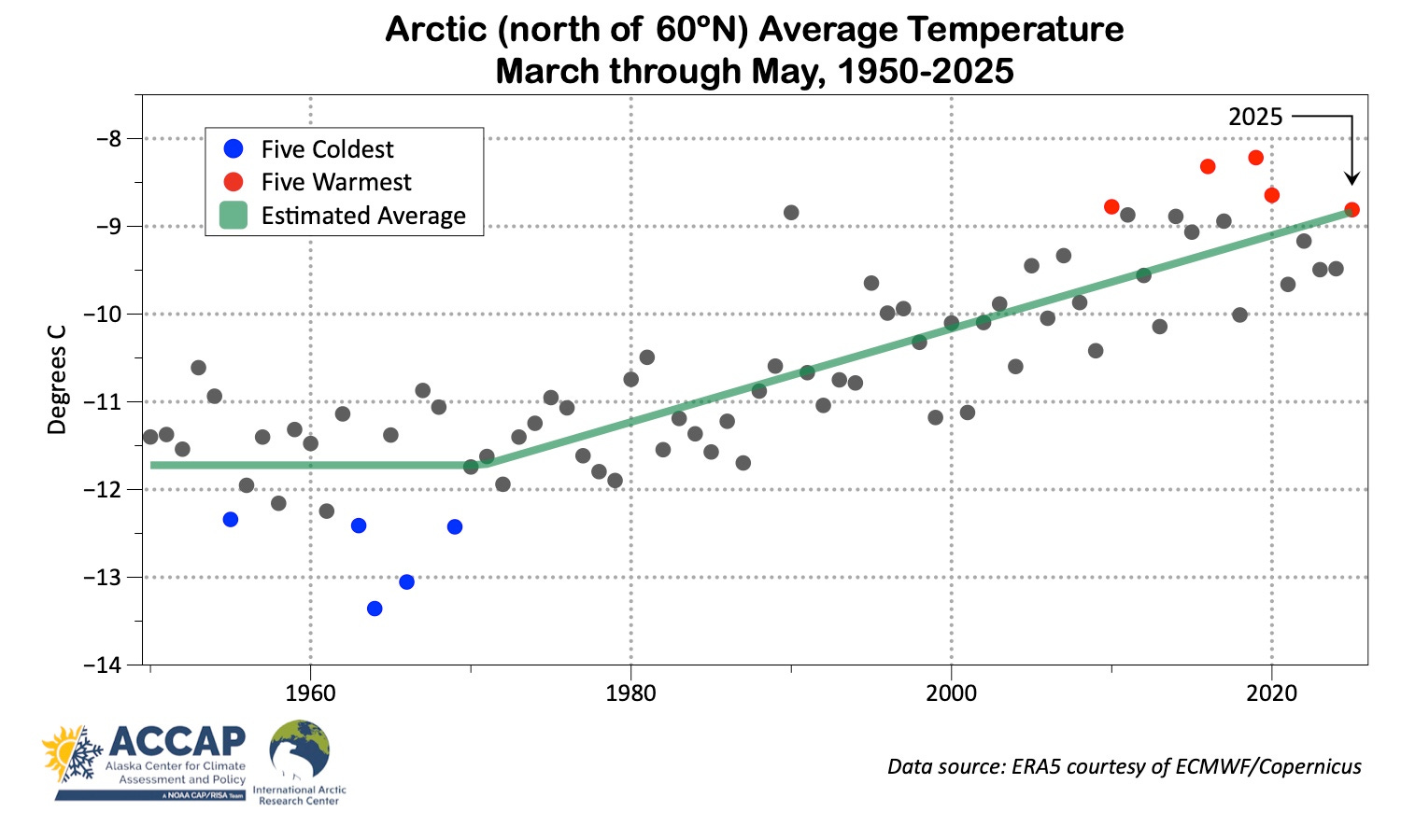
Figure 2 shows the time series for the Spring average temperature for the Arctic overall. This was the mildest Spring since 2020 and fifth highest average temperature since 1950. For Arctic lands this Spring was also the mildest since 2020 and fourth highest overall.
Arctic Heat in Spring
I try to keep abreast of weather scale extremes in Alaska and northwest Canada but don’t have a way to systematically track extremes all around the Arctic. But alert readers brought a couple of important May records to my attention, which I appreciate very much.
Iceland set a national record high temperature for May at Egilsstaðir Airport (eastern Iceland) when the temperature peaked at 26.6°C on May 15. Details on this extreme event from the Iceland Met Office are here. The all-time Iceland temperature record is 30.5°C on June 22, 1939 at Teigarhorn.
At the end of the month, the South Slave region of Northwest Territories, Canada saw extreme heat. On May 30, high temperatures at Hay River (33.7°C), Fort Smith (33.1°C) and Fort Providence (32.6°C) were all (evidently) new May record highs.
Precipitation
Spring is the driest of the canonical seasons for the Arctic overall, though winter is slightly drier on the Pacific side of the North Pole. Precipitation this Spring ranked as the fourth highest since 1950, and 54 percent of the Arctic had above normal totals. At or near record high totals in ERA5 reanalysis occurred in parts of mainland Alaska, the western Canadian Arctic islands and parts of Greenland. The Bering Strait region into northwest Alaska had significantly below normal totals, as did areas of Nunavut and Northwest Territories, Canada west of Hudson Bay.

Sea ice and snow extent
The Arctic sea ice maximum for the year was reached in late March (my post on this here) and was the lowest annual maximum in the 47-year satellite record. However, ice coverage was very slow to decrease in April (more details in my April climate summary, here), and both April and May extent was not at the (near) record low levels seen during the winter. Regionally for May, unusual open water areas were found in both the Kara and Laptev Seas north of the Russian coast.

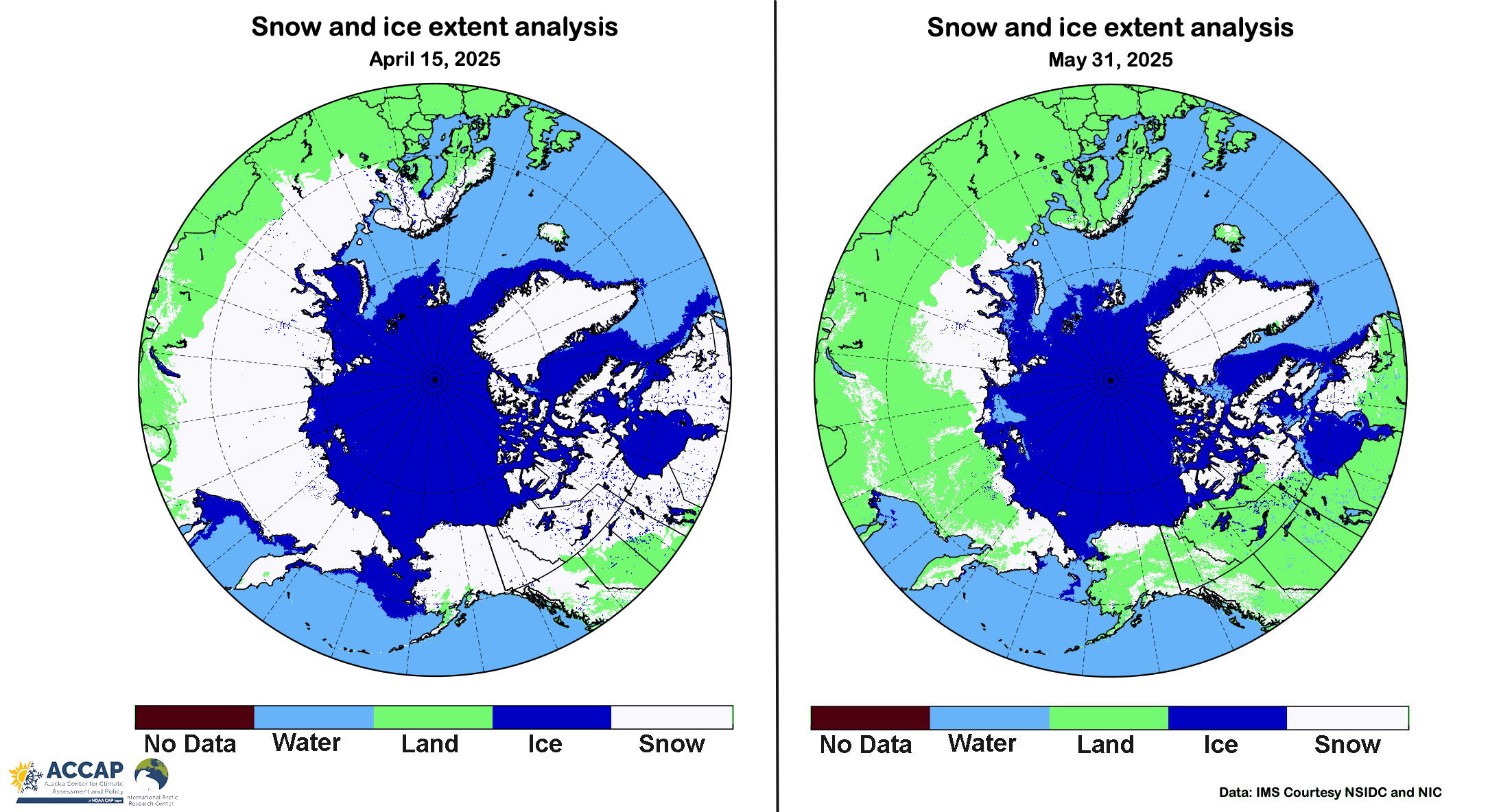
The Spring loss of the winter snow pack in the Arctic is an important event in the seasonal cycle, bringing abrupt shifts to ecosystems, weather and societal activities. Snow cover decreased rapidly the second half of Spring 2025. Figure 5 compares the snow and ice cover extent on April 15 (left), when snow remained on the ground almost everywhere north of 60 to the end of May (right), when snow melt was complete over most of the low-elevation Arctic south of 68°N. However, significant areas with snow cover persisted at the end of May south of 68°N in western Siberia, far northeast Russia and Nunavut, Canada.
Spring 2025 Upper Air
Seasonal average upper air patterns sometimes provide context for the observed surface conditions. But not always. Not infrequently, a three-month average does not capture surface temperature and especially precipitation patterns because of the importance of the presence or absence of snow or ice cover, or the the impacts of transient storm systems that may have little or no reflect at the steering flow level of the atmosphere. The mid-atmosphere pattern for Spring 2025 shows both sides of this coin.

Low pressure aloft over the Bering Strait correlates well with the below normal temperatures that dominated here. On the opposite side of the pole, the low centered near Svalbard is proximate to an area of near normal (not below) temperatures, likely due to the presence of more open water than would have been the case historically. The high aloft northwest of Alaska near 80N/180 is correlated with below average precipitation in the same region but nothing here suggests the (near) record high precipitation over the western Canadian Arctic islands.