


January 2025 Snow Pack
Highs, lows and impacts

Here’s a short update on Arctic and Alaska snowpack as of mid-January. This is prompted by poor snow conditions in parts of Alaska that are threatening late winter and spring activities around the state.
Arctic
Figure 1 plots the Pan-Arctic snowpack snow water equivalent on land as of January 10 as a percent of the 1991-2020 median from the ERA5 reanalysis. Note that in ERA5, glaciated areas and ice caps have a fixed snow water equivalent, which is why most of Greenland shows up as near normal snowpack. For non-glaciated areas, as is often the case with snow, there are considerable differences over comparatively short distances. The large area across the eastern European Arctic and western Siberia with above normal snowpack is notable, as are smaller areas in Interior Alaska and Nunavut, Canada.

On the below normal side, thinner than usual snowpack was found in Iceland, the inland Nordic Arctic and the Bering Strait/Southwest Alaska regions.
Alaska
Zooming into Alaska, Fig. 2 plots the same January 10 data as in Fig. 1 but with more detail. Important: there is a five-six day delay in ERA5 hourly so this is the analysis of the snowpack just before the extremely mild (and in western Alaska stormy) weather of January 11-14. Much of the Interior had above normal snowpack, while Southwest Alaska and parts of Southcentral were well below median.

The National Weather Service Alaska-Pacific River Forecast Center provides a daily plot of snow depths using data from a number of different networks. At this scale there are complications for interpretation due to significant elevation variation and underlying data quality issues: the vast majority of the data plotted in Fig. 3 are from automated snow depth sensors.
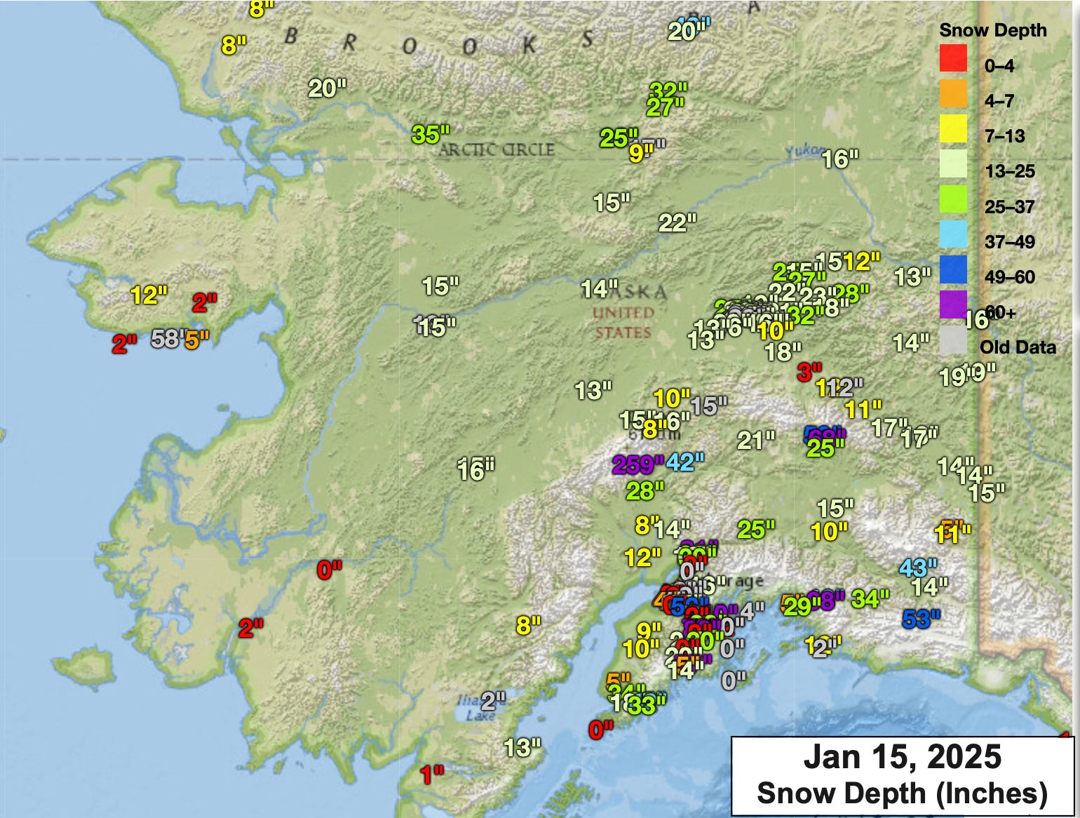
It’s difficult to get a sense of the big picture due to the paucity of observations away from the road system, but what there is in western Alaska shows the very low snowpack suggested by the ERA5 analysis in Fig. 2.1
Impacts
Impacts of the regionally low snowpack are already being felt in Alaska. The Norton Bay Classic Basketball Tournament in Koyuk (eastern Norton Sound) was delayed a week due to poor travel conditions. KYUK radio in Bethel reported Thursday (Jan 16) that the iconic Kuskokwim 300 Sled Dog Race, which was scheduled to start January 24 has been delayed for two weeks. The Yukon Quest Alaska has extended the sign-up deadline for this years’ race due to uncertainties in trail conditions. And most conspicuously, the Iditarod Trail Committee is considering alternate race routes due to poor trail conditions.

Newsletter reader J. Cable kindly pointed out to me that in addition to widespread low snow along the planned “southern route” for Iditarod, high resolution Sentinel satellite imagery from January 14 suggests low to no snow pack along part of the Iditarod trail between Rohn and Nikolai, an area infamous for poor trail conditions even in otherwise good years.
Technical Details
ERA5 snow water equivalent data available here.
The Alaska-Pacific River Forecast Center homepage is here. In situ snow depth and snow water equivalent is available under the “water supply” tab.
In recent years the Natural Resources Conservation Service has been building out their network of SNOTel stations in Alaska, but there is only one site in western Alaska, indeed anywhere west of 153°W longitude (Kelly River, north of Kotzebue) that has a long enough period of record to derive percent normal snowpack.
The Rohn to Nicolai route is frequently bad. I've flown over after working at Rohn and seeing nothing but dirt. I don't know that Iditarod ever considered a route change because of that. The gorge is another matter