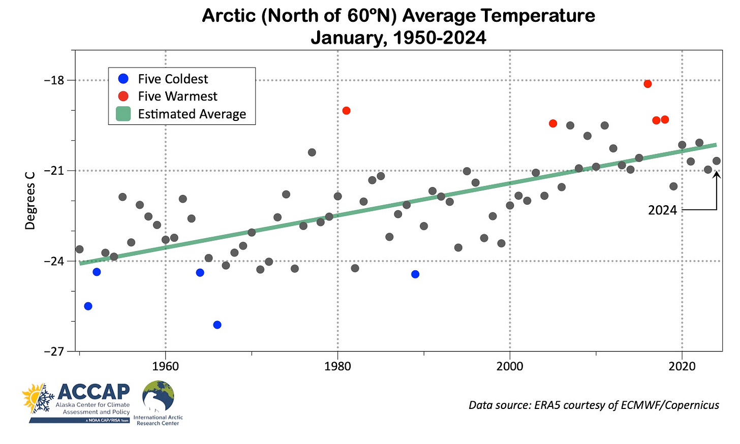
The global average temperature for January 2024 was the highest (for January) on record. In the Arctic though, the month was not especially mild for so far in the 21st century.
Arctic Summary
Average temperature departures from normal for January were above the 1991-2020 baseline normal over the eastern Canadian Arctic, western Siberia, the Russian far northeast (Chukotka) and northern and western Alaska, though only in Canada was the month in the top three mildest in the past 75 years. On the flip side, eastern Interior Alaska and northwest Canada, the Nordic Arctic and parts of eastern Siberia were colder than normal, with some areas north of the Sea of Okhotsk in the top three coldest. For the Arctic as a whole (land and sea poleward of 60°N) this was the 14th warmest January since 1950, but for just the Arctic land areas, the average temperature was almost exactly at the 1991-2020 normal, and was the 24th warmest since 1950.

Figure 2 shows the time series for Arctic-wide January average temperatures since 1950. Unlike some months/seasons, e.g. the annual average temperature, as shown in Fig. 2 of my Arctic 2023 climate summary, January does not show an obvious abrupt break in the rate of warming.

While January is brighter month than December, there is still minimal direct solar heating in the Arctic. The sun remains below the horizon all month poleward of 73°N and it’s only along the southern periphery, south of 63°N, that the maximum solar elevation reaches 10° above the horizon by the last days of the month. The practical importance of this from the climate perspective is that in January, the year-to-year variability is largely dependent atmosphere circulation differences and longer term warming is driven by increased heat transport through thinner ice, increased water vapor and increased greenhouse gas concentrations.
Alaska Summary
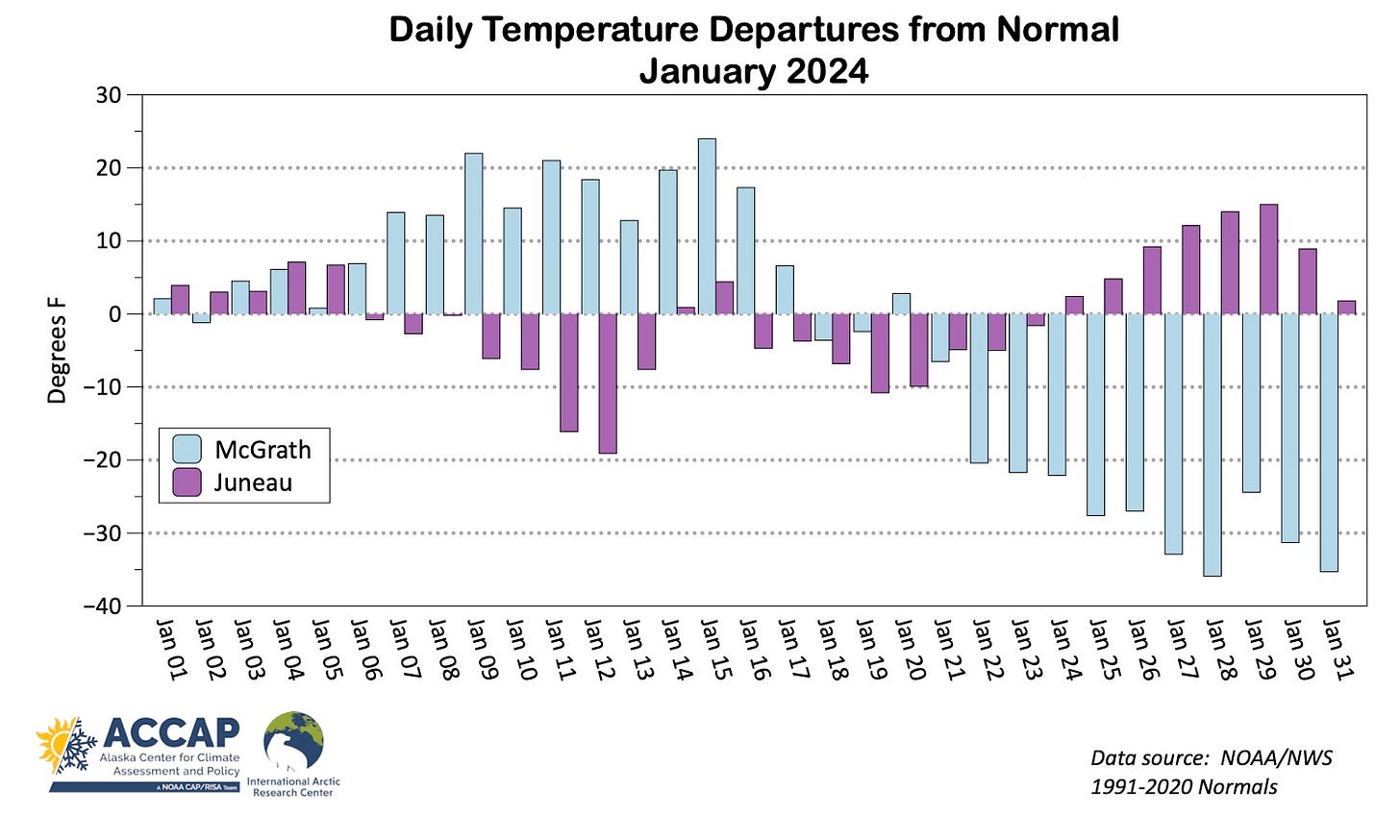
Most areas in Alaska had highly variable weather in January. For mainland Alaska in general the first three weeks of the month were mild but the last ten days were quite cold, while Southeast Alaska saw that sequence reversed. More for details on the late month cold, see my post here. This kind of sub-monthly variability is not uncommon but seemed especially pronounced in January. As a result, in many areas the monthly average doesn’t quite convey the character of temperatures. Fig 3. illustrates this by plotting the daily average temperature departure from 1991-2020 normal during January for McGrath (western Interior) and Juneau (central Panhandle). The fact that the departures are often of the opposite sign is common in the cold season and reflects the difference in longitude between Southeast and most of mainland Alaska, which is large enough for different parts of Alaska to be in different sectors of the regional storm track.

For the month as a whole, the most persistent cold (relative to normal) was in the Porcupine River drainage (Fort Yukon, Alaska to Old Crow, YT area), where this was the coldest January since 2012, and for the Yukon Territory overall this was second coldest January in the past decade, with only 2020 colder. In contrast, the western North Slope was persistently mild, with Utqiaġvik reporting the eighth warmest January in the past 104 years.

Community temperatures during the month varied from 57°F (13.9C) at Metlakatla to -59°F (-50.6C) at Allakaket, and both occurred on January 28.
Precipitation
Precipitation (melted snow plus any rain) in January was above normal across the eastern Bering Sea, the North Slope coast, the far eastern Alaska mainland, most of the Yukon Territory and northern Southeast. Parts of Southcentral and the central and western Interior had below normal totals.

Cold Bay, at the far southwest end of the Alaska Peninsula (northeast of Unalaska) reported (at least) 6.82 inches (173.2mm) of precipitation (mostly rain), exceeding the previous January precipitation record 6.45 inches (163.8mm) set in 1957. Juneau Airport precipitation totaled 9.68 inches (245.9mm), the fifth highest January total on record (since 1943). The greater Anchorage area has extremely complex precipitation patterns due to the interactions of the mountains to the east and west and Cook Inlet in between, but this month was more extreme than most: Anchorage Airport total precipitation came in at 173 percent of the 1991-2020 normal and the tenth highest since 1954. This is not a measurement error: almost exactly the same total was independently measured at the National Weather Service Forecast Office at Sand Lake, but every other climate observation in the area had near to below normal totals, both at low elevation and in the mountains.
Snowfall and Snowpack
Juneau Airport received 76.8 inches of snow in January, the highest January total on record (since 1943) and second highest monthly total. More than a third of this total, 34.1 inches (86.6cm), fell January 21-23 and is the third highest three-day total on record. The very heavy snow was mostly confined to the greater Juneau area. Both the northern and southern Panhandle saw below normal snowfall and in the southern Southeast there are concerns for snow drought as the mountains had little to no snow cover at the end of January. Most other parts of Alaska, January snowfall was generally near to below normal.
The snowpack (snow water equivalent, i.e., the amount of water in the snowpack) during January was near to above normal over much of the state (Fig. 4), with the exceptions of southern Southeast and parts of southwest Alaska mainland. The Porcupine River valley (Fort Yukon to Old Crow area) had the highest January snowpack in the ERA5 reanalysis since 2000.


