


Autumn Snow Decreasing
More Rain, Less Snow

The vast majority of winter precipitation over mainland Alaska falls as snow (which makes the rare rain events highly impactful). In summer, snow accounts for almost none of the precipitation except at the highest elevations. Autumn and spring are transition seasons. This is transition is generally less conspicuous in the spring because spring is the dry season for most of mainland Alaska, so the shift in predominate precipitation type is often most noticable in the autumn.
The Story from Reanalysis
Figure 1 shows the average percent of autumn (September through November) precipitation that fell as snow in the 1991-2020 reference period in ERA5 reanalysis.1 The major mountains ranges are evident, as is the strong Gulf of Alaska to inland gradient.
In this post “snow” from the ERA5 reanalysis means the liquid equivalent of precipitation (snow water equivalent, or SWE) that fell as snow and not the vertical depth of “snowfall”. i.e. what you might shovel off your car or deck. So a powdery snowfall of, say, five inches that melted down to 0.25 inches inches liquid (a common 20-1 ratio) and a wet, heavy snow of two inches that melted down to 0.25 inches liquid (a soggy 8 to 1 ratio) both count the same in ERA5 reanalysis snow. Precipitation, as usual, is the liquid equivant of all the water that falls in whatever form (snow, sleet, rain, etc.).

Of course, there is a transition and sometimes quite abrupt change from rain to snow during the autumn months, and the changing seasonality of snow is worth a post by itself. In order to keep this post at a reasonable length I’ll focus here on the change in the amount of snow.
Figure 2 shows the 50-year change in average autumn snowfall: no change is shown over the mainly oceanic areas that typically receive less than 1 cm (0.39 inches) SWE in the autumn. The most obvious feature is that snow has decreased over nearly all of Alaska except for parts of the North Slope and southeast Interior, and the decrease is significant across the entire Bering Sea region as well parts of the western Interior, Southcentral and the outer coast of Southeast Alaska.

Now of course it is possible, in principle at least, that the snow is decreasing because total precipitation is decreasing. To assess this, the 1973 to 2022 change in autumn average total precipitation (rain and snow) is shown in Fig 3. Clearly, this looks almost nothing like Fig. 2. There are only weak (not significant) changes over nearly all of Alaska, though there is stronger trend right along the North Slope coast and more widely across Chukotka (far northeast Russia).

This strongly suggests that autumn snowfall is decreasing because more of the precipitation is falling as rain rather than snow rather than less water overall falling from the sky.
Station Analysis
While the ERA5 reanalysis provides a consistent and independent data set to analyze trends, it’s wothwhile to look at some situ precipitation and snow observations. Unfortutately, the National Weather Wervice ended snow observersation at the rural Alaska offices in 2019 (some offices earlier), so there are now only a tiny number of climate stations in Alaska that have complete or near complete precipitation and snowfall data for the period for the past 50 or more years.
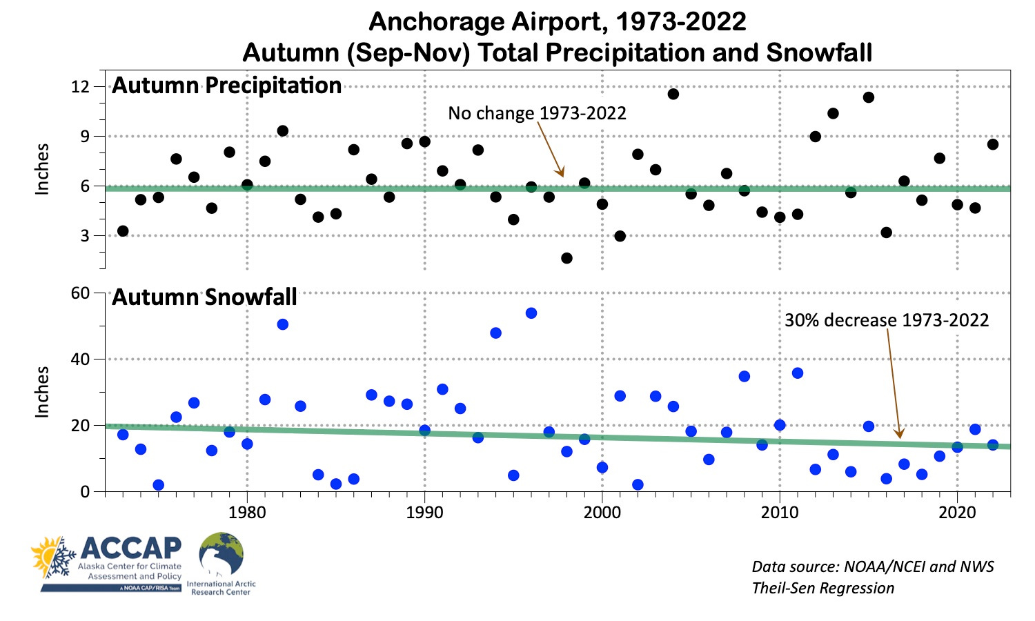
Anchorage is the only place with ongoing snow observations that is in an area with a greater than 30 percent decrease in snowfall in Fig 2. Figure 4 plots the past 50 years of autumn precipitation and snowfall at Anchorage Airport. Remembering that snowfall as reported by NWS (vertical depth) is not the same as the SWE from the reanalysis, we still get a very similar story: autumn precipitation has not significantly changed, while snowfall has trended downward. Also of interest, there hasn’t been an autumn since 2011 with as much snow (~20 inches) as would have been typical in the 1970s.
Both these lines of evidence support what many Alaskans have noted: snow is less reliable at certain times in the autumn than it used to be, and this has cascading impacts to other parts of the climate system, the ecosystem and human activities.
Technical details:
Technical details: Precipitation and snow change maps using ERA5 reanalysis data from ECMWF/Copernicus.
Anchorage Airport precipitation and snowfall data aquired from xmACIS, a contract service provided by the NOAA funded Regional Climate Centers and availabe at https://xmacis.rcc-acis.org/
Change statistics all derived using Theil-Sen Regression to reduce the impact of outliers.
It’s not realistic to do this kind of analysis using station data, since in the US the liquid amount rain vs. snow has never been systematically measured. This was done in Canada at some locations prior to the advent of automation in the early 21st century though with varying levels of plausibility.