


Arctic Climate Science and Data Loss
Potential Impacts of losing U.S. data

The destruction of human and public health science in the US is now fait accompli, and while the gutting of weather and climate information and services is proceeding, it’s happening at a slower pace. As of this writing, the flow of basic weather and climate data has not been distupted. Nonetheless, I thought it might be useful to outline, based on my understanding, what the loss of United States government run or funded near real-time data might mean for Alaska and Arctic climate science. If you have information about systems that I’ve missed here please let me know.
State of Alaska
The most direct and immediate impact would be the gathering and dissemination of in situ observations in and around Alaska, including observations on land and in Alaska waters. Except for typically ephemeral home weather stations, the vast majority of weather and climate observations of any sort are done by civilian Federal government agencies1. This includes:
Airport weather observations (Federal Aviation Administration and NOAA/National Weather Service)
Climate reference network observations (NOAA/National Environmental Satellite, Data, and Information Service)
Ocean surface/level observations (NOAA/National Ocean Service)
Surface observations mostly in remote or higher elevation areas to support wildfire prediction and snowpack and water supply analysis and management and river forecasting (Natural Resources Conservation Service, Bureau of Land Management, National Park Service)
Upper air (weather balloon) observations from 14 locations and the seven weather radars in the state (NWS and for radar, FAA)
The cooperative observer program, in which individuals or organizations voluntarily take once-a-day climate observations (NWS)
There are a small number of additional data gathering programs run by federal agencies and academic institutions (almost invariably with Federal funding) that provide real-time data. There are also a number of citizen science and Indigenous environmental observation initiatives, most, though perhaps not all, are brought together with Federal funding.
Impacts to climate science
All of the 75+ year climate stations in Alaska are either FAA/NWS airport stations (the vast majority) or a handful of the cooperative stations. Data quality from the long term airport sites, in terms of accuracy and completeness of observations, has declined significantly as automation progressed in the past 20 years. The number of active cooperative stations in Alaska peaked in the 1970s and early 1980s, and except in Southeast Alaska are now confined almost entirely to locations on Alaska’s limited road system. While past climate data is archived by the US government at the National Centers for Environmental Information (NCEI), the information is independently archived by many organizations and individuals, so while loss of this past data from NCEI would be very inconvenient, it would not be lost to the world. On the other hand, loss of future data would be a serious and irrecoverable blow to understanding of Alaska climate and weather in context.
Upper air (weather balloon) observations, which have become less reliable (i.e. more scheduled observations being missed) in Alaska since being automated in the late 2010s, remain important for detailed understanding of the atmosphere’s structure. Like surface observations, data from past upper air observations are widely distributed, but the loss of this future information would materially degrade the quality of physics-based weather and climate models.
The Arctic
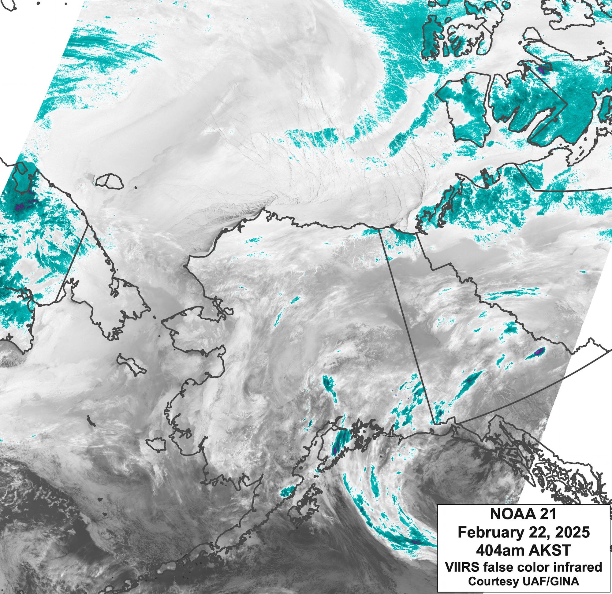
The vast majority of Arctic data that feeds weather and climate analysis models comes from earth-orbiting satellites, with additional data from weather balloons launched around the world and from in-flight aircraft. There are also a significant number of buoys deployed on the Arctic ice pack that report real-time observations, but only a fraction of these are US agency or agency-funded contributions.
The US owns and operates large numbers of satellites, both civilian (principally NOAA and NASA) and military, in high altitude earth-orbiting (geosynchronous) and low altitude polar-orbiting satellites that provide, with suitable processing, a wide variety of information relevant to the Arctic (example in Fig. 1). This includes sea ice concentrations and extent, sea surface temperatures and multi-channel information that services as inputs to weather and climate models.
Impacts to climate science
Unlike in situ land observations, which are largely national functions, the European Union and other countries operate satellites that provide similar or identical environmental data to that gathered by US satellites. But it is important to remember that all satellite-sensed information has to be processed in order to turn electrical signals into meaningful data. So while simply not acquiring the satellite data is the most obvious way to lose data, another potential source of disruption/data loss would be the ability of federal agencies or academically based organizations to process acquired signals into data. Because of the international redundancy, the loss of space-borne observations from the US would have less dramatic impacts to Arctic climate science than to Alaska specifically, but the decrease in coverage would still be significant.
That said, there are a few satellites at least partially operated by the US that do provide (to the best of my knowledge) unique information important to Arctic climate science. The GRACE (Gravity Recovery and Climate Experiment) satellite series, operated jointly by NASA and the German Aerospace Center (DLR) is critical for monitoring ice loss from the Greenland Ice Sheet. Important for Arctic environmental monitoring, specialized satellite-derived indices used to monitor things like vegetation greenness and ocean algae can be derived from both US and European operated satellites, but as these indices are sensitive to sensor characteristics specific to individual satellites, the loss of US satellite observations would potentially impact understanding of multi-decade trends.
The main contributions to real-time weather observations by the state of Alaska is through 1) the Road Weather Information System, though I would guess (don’t know) this is largely or entirely funded through the Federal Department of Transportation and 2) ocean level observations by the Department of Natural Resources Geological & Geophysical Surveys.
Thanks for all you do. Sad times.
It’s just so hard to imagine with the challenges we already face with global warming that our ‘leadership’ has now become the most immediate catastrophic influence on the scientific research and resulting in devastating loss of hard earned data.
Thank you, Rick for your continuous leadership and service to Arctic Communities.