


Arctic & Alaska Autumn 2024 Climate Review
Warm and Wet…Again

Temperatures
Autumn 2024 was another very mild season across much of the Arctic (lands and sea poleward of 60°N). Based on ERA5 reanalysis, the September through November average temperature was higher than the 1991-2020 normal baseline normal across 87% of the Arctic. As you can see in Fig. 1, unlike some months/seasons, only small areas were even as much as 1°C below normal, though this did include Iceland. In contrast, Nunavut Canada was exceptionally mild, by far the mildest autumn on record.

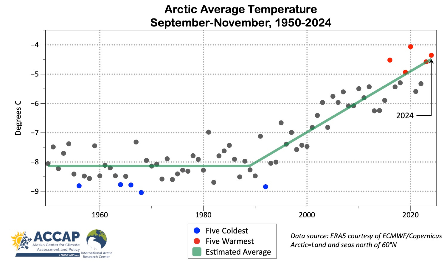
The Arctic autumn average temperature time series since 1950 in Fig. 2 shows the familiar pattern of a dramatic increase in temperature (in this season 3.6C) starting around 1990. This autumn was the second warmest on record, with all of the five warmest having occurred since 2016. For Arctic land areas only, this was the third warmest autumn.
Precipitation
Average precipitation (water equivalent of snow plus rain) this autumn for the Arctic overall was the highest on record. This was driven by large areas in northern Canada and Greenland that had twice or more of the 1991-2020 normal total. Almost two-thirds of the Arctic had above normal total precipitation for the autumn.

Sea ice
Arctic sea ice extent reached its annual minimum in early September (my post on this here) but was slow to increase thereafter. Figure 4 shows the September, October and November monthly average ice concentration and the average extent rank since 1979 in data from the National Snow and Ice Data Center.
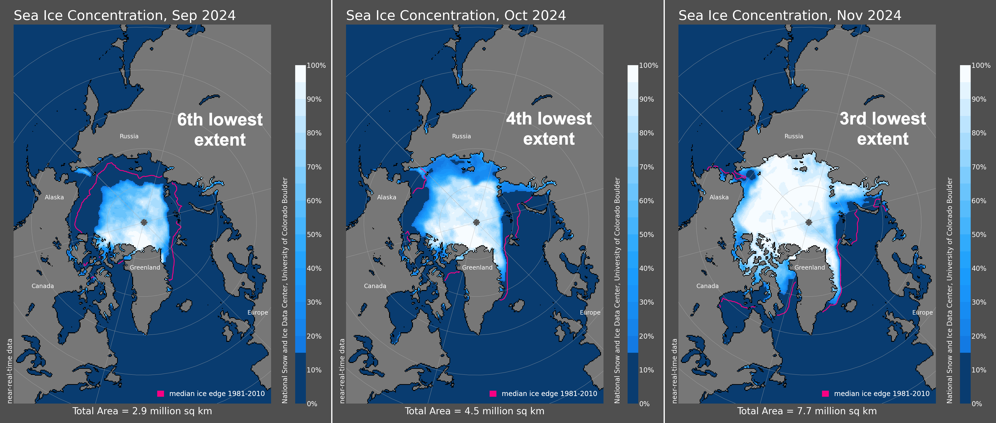
By November, average ice extent in the Pacific Arctic was not far from the 1981-2010 median but was well behind in the Atlantic sector and northern Hudson Bay.
Alaska in November
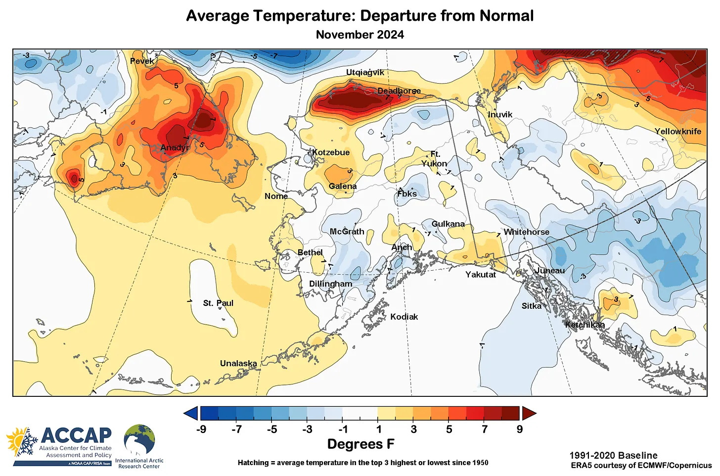
November average temperatures in Alaska were mostly not too far from normal (Fig. 5), with the major exception of the North Slope, which was again quite mild. At Utqiaġvik the average temperature for the month was 5.7F (3.2C) above the 1991-2020 normal, but in a monument to how fast it’s warming, four of the five Novembers between 2019-2023 had an average higher average temperature than this year. Southwest Alaska was a bit cooler than normal, and in sharp contrast to areas to the north, the central and eastern Brook Range was colder than normal.
Reliable Temperatures in Alaska in November ranged from 58F (14.4C) at Kodiak on November 21st to -48F (-44.4C) at the Robertson River cooperative station west of Tok on the 29th.
November was quite dry relative to normal over most of the state (Fig. 6), though of course with exceptions. Following the soggy summer, the lack of precipitation was especially notable in southwest Alaska, where Bethel had the lowest autumn precipitation total in more than 20 years.

Snowfall was correspondingly low in November. A few places in the Eagle River area near Anchorage reported near or slightly above 20 inches (50cm) during the month. The highest reported total was 26.8 inches (68.1cm) at the Snettisham Power Plant southeast of Juneau. In areas of mainland Alaska that had significant snow in late October, the late November snowpack was closer to normal. However, parts of western Alaska had quite thin snow cover at the end of the autumn.
Figure 2. says it all. Another fifty years at that slope and there'll be a 45° N latitude climate at 70° N. lat. Astounding warm up.
The Chalkyitsik RAWS station also recorded -48F on Nov 28. Is it unreliable?