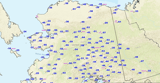
The Alaska cold snap of late January and early February 2024 is history. For the Interior, northern Bering Sea region and Southcentral this was generally the most prolonged deep cold weather in more than a decade. I’ve detailed the January portion of the cold snap here. Figure 1 shows the lowest temperature reported between in the 12 days between January 24 and February 4. Almost all of these will be the lowest temperature of the 2023-24 winter.
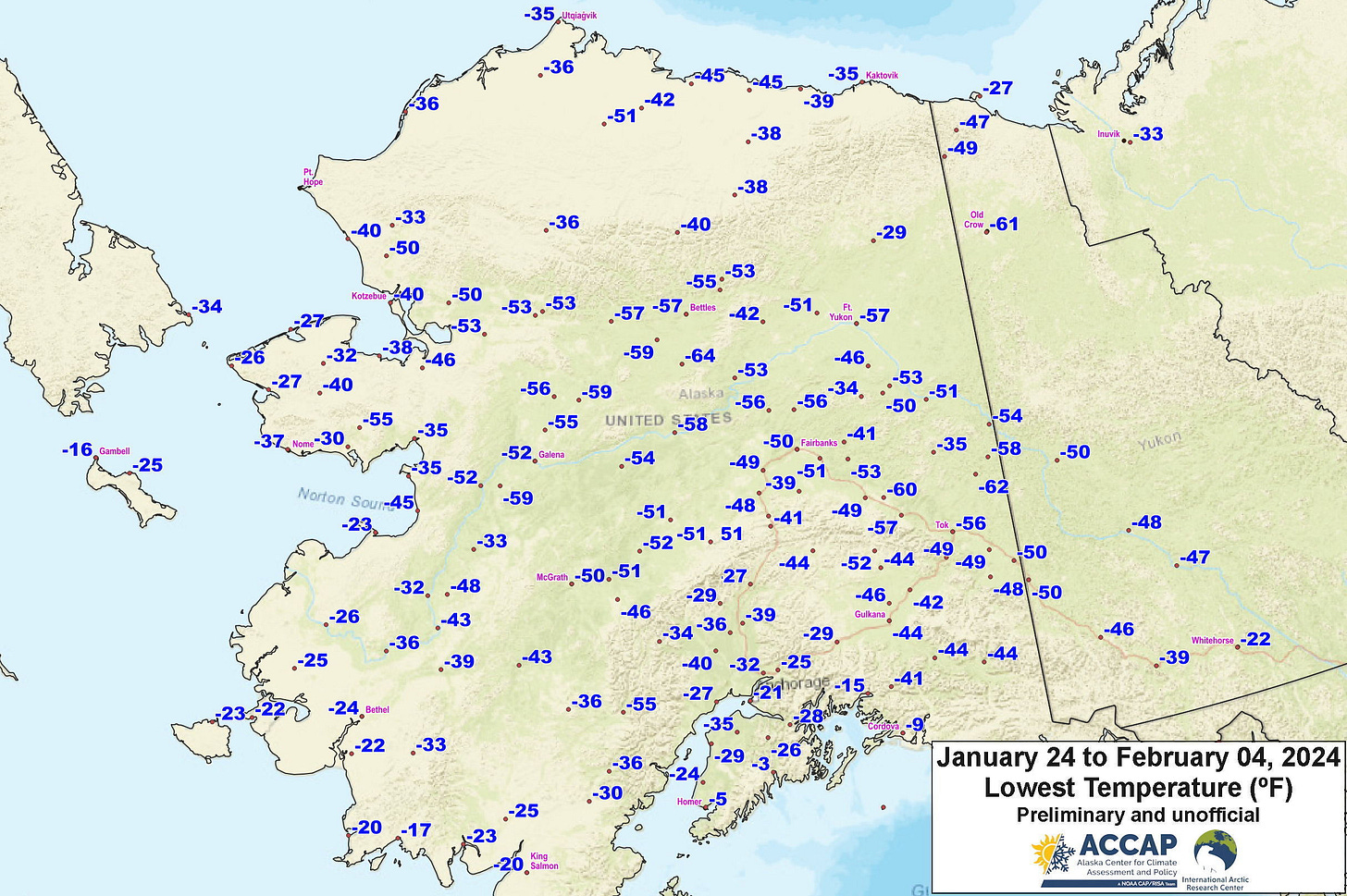
The lowest reliable temperature was -64F (-53.3C) at an automated weather station in the Kanuti Flats about 35 miles (57km) southeast of Allakaket. However, it’s quite possible that lower temperatures occurred in river valleys on the south side of the eastern Brooks Range. The lowest community temperatures reported was -62F (-52.2C) at perennial cold spot Chicken, and the NWS cooperative station at a farm 20 miles southeast of Delta Junction reported -60F (-51.1C), both on February 3.
Urban Alaska highlights include:
Anchorage area, all on February 3:
Anchorage Airport: -21F (-29.4C), lowest since January 2009
Anchorage/Merrill Field: -25F (-31.7C) lowest since February 1999
JBER/Elmendorf: -24F (-31.1C) lowest since January 2009
JBER/Ft. Richardson: -34F (-36.7C) lowest reported in the Anchorage area
Campbell Creek Science Center -30F (-34.4C)
Fairbanks area, all on February 3:
Fairbanks Airport: -50F (-45.7C), lowest since January 2017
Ft. Wainwright: -52F (-46.7C), lowest since January 2017
UAF/College Observatory: -46F (-43.3C) lowest since January 2017
North Pole: -55F (-48.3C), lowest since January 2017
Goldstream Creek: -53F (-47.2C), lowest since January 2012
Note that there are a few long-term cooperative climate stations that only report after the end of the month, so February data will not be available until early March
Cold Snap 2024 Duration
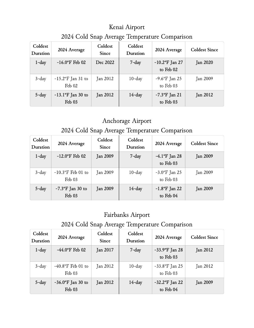
The duration of very low temperatures in an important factor in any Alaskan cold snap. Table 1 lists the lowest average temperatures for Kenai, Anchorage and Fairbanks for durations ranging from 1 to 14 days in length and the last time it had been as cold or colder. A glance shows that 2012 and 2009 show up quite a bit as the last time it was colder, and it’s this kind of analysis that informs my statements like “…most prolonged deep cold weather in more than a decade.”
Cold Snap 2024 in Context
The textbook definition of an extreme environmental event is an event at a specific time and place that is near or beyond previously observed limits. By this standard the 2024 cold snap was not especially notable. Only two daily record low temperatures were set, mostly significantly -39F (-39.4C) at Talkeetna on February 1. Anchorage International Airport also set a new record low of January 31 of -18F (-27.8C).1 High temperatures on February 2 or 3 in some places were quite low for so late in the winter but no records were set.
But that does not mean the cold snap wasn’t impactful because, by 21st century standards, it was indeed cold. Figure 2 plots the number of days each winter at Fairbanks (Weather Bureau downtown 1930-1951 and Airport 1952-present) with a daily average temperature of -30F (-34.4C) or lower. The time varying estimate of the average number of days that cold has decreased by 63 percent in the past 85 years. So, while ten days with an average temperature of -30F (-34.4C) or lower this winter is above the modern average, prior to 1980 ten days would have been fewer than the typical winter and until about 2000 was not at all unusual.
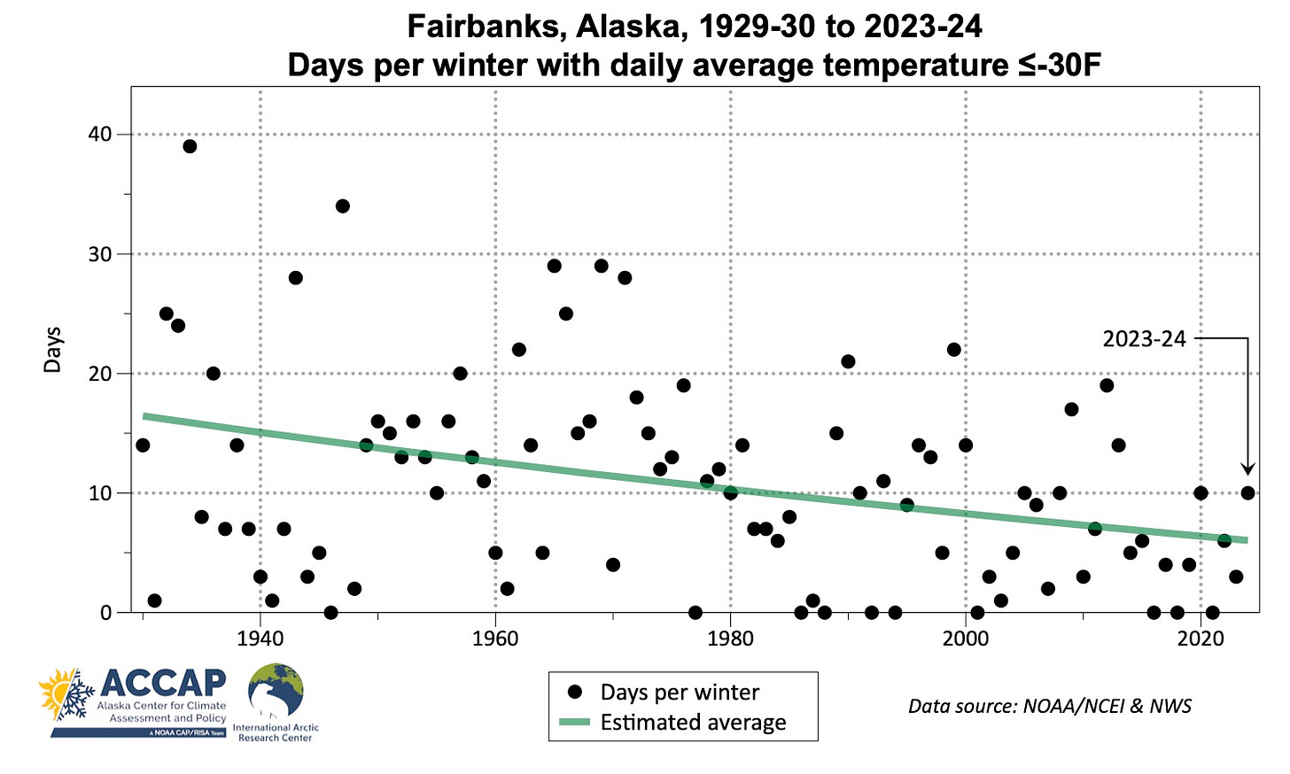
This change is important to modern northern societies because prolonged very low temperatures reveal weaknesses in mechanical system that are otherwise inconsequential or slower to cause problems. When deep cold was more common, systems had to be more robust because they were taxed more often. Nowadays, this stress is less frequent, so temperatures that are not close to historical levels are producing significant impacts.
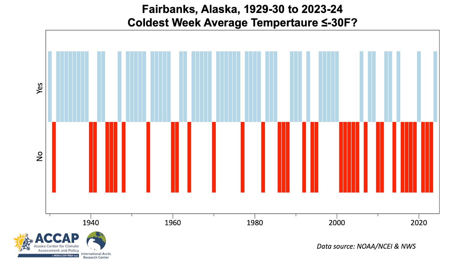
Figure 3 approaches this question from a different angle. Again, for Fairbanks (airport), we ask simply: for each winter 1929-30 to 2023-24, did the coldest week of the winter have an average temperature of -30F or lower? In the 48 winters between 1929-30 and 1976-77, there were 13 winters without a week that cold. In the 47 winters since then, there have been 23 such winters, and it’s clear that the frequency of winters when there is no week that cold has increased substantially in the past 25 years.
The most intense cold snap in the past century in the Anchorage area was in the winter of 1946-1947, when the Weather Bureau at Merrill Field recorded 12 straight days with low temperatures of -30F or lower (January 24-February 4), with an absolute low of -38F on February 3. Climate observations are available at Anchorage International Airport since Spring 1952 and NWS does not use the Merrill Field era observations in reporting daily records for Anchorage.



CHICAGO WARM SNAP. The last 25 days in a row have all been Above Normal here in Chicago (ORD) with an anomaly of +11.7°. While I can't easily prove it - this is almost certainly the longest and biggest Temp anomaly on record. We are also likely to end up as the warmest winter on record - or at least in the top 3.