Spring 2026 is Progressing
Arctic and Alaska updates

Spring is time of rapid environmental transition in the Arctic, with a lot happening in short order. Here’s a snapshot of where things stand as of mid-May.
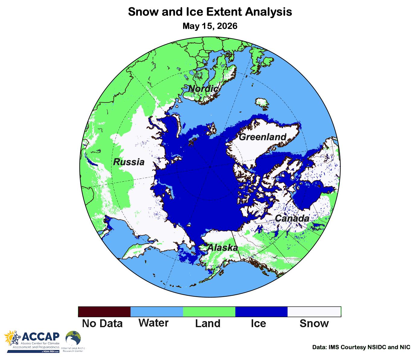
Snow Cover
The Arctic snow pack is now rapidly melting out at low elevations south of 66°N. Snow cover extent in the Arctic decreased nearly 30 percent between March 1 and May 15 and is the lowest for May 15th since 2023. With very mild (and dry) weather since March, most of Nordic Arctic except in the mountains is now snow-free, as is the southwestern Northwest Territories, Canada, low elevation Interior Alaska and much of southern Asian Arctic west of the Sea of Okhotsk.
Sea Ice
Northern hemisphere sea ice extent remains very low for this point in the season. As of May 15th, total extent ranked as fourth lowest in the satellite era (since 1979) in the National Snow and Ice Center (NSIDC) Sea Ice Index, fifth lowest in U.S. National Ice Center/NSIDC Multisensor Analyzed Sea Ice Extent (MASIE) and Japanese Aerospace Exploration Agency (JAXA) analyzes, and sixth lowest in the EUMETSAT OSI SAF analysis.
Regionally, ice extent in all the peripheral Arctic seas is below median. Open water areas are developing in Hudson Bay, which is typical for this time of year. Ice extent is Baffin Bay (between Canada and Greenland) is the second lowest in the satellite era, Sea of Okhotsk third lowest and Barents Sea fifth lowest.
Alaska Spring River Break-up
As of Saturday morning May 16, (Fig. 2), break-up on Alaska rivers is largely complete in Southcentral, the eastern Interior and Yukon Territory in analysis by the NWS Alaska-Pacific River Forecast Center. In southwest Alaska the Kuskokwim is at least partially open to the Bering Sea but there is still considerable ice moving downstream. The Yukon River below Grayling is still mostly ice covered. Break-up on the Seward Peninsula and Northwest Arctic Borough rivers is just starting. On the North Slope, break-up is still two to four weeks away.
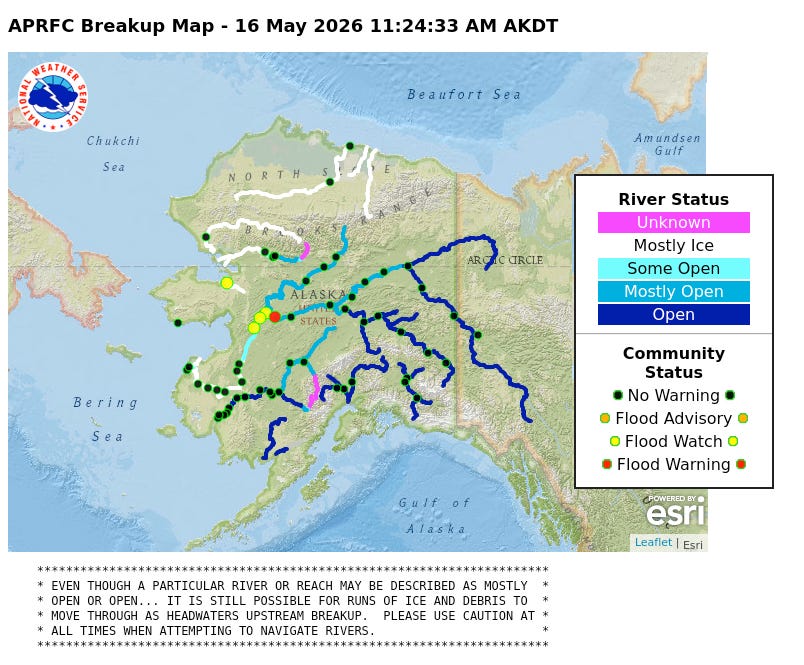
A State of Alaska disaster declaration was issued on May 11th for flooding at Hughes and Chalkyitsik from flooding May 7-10th.
High water occurred on Yukon River below Tanana May 12-16, with some water over low lying areas in Ruby and Galena, but through Noon May 16th there’s been no serious flooding reported.
The tripod on the Kuksokwim River at Bethel moved downriver on the morning of May 12. This is a few days later than the modern average date of break-up but would been slightly earlier than average prior to 1980. The trend toward earlier break-up, about a week in the past century, is similar to trends on Interior Alaska rivers.
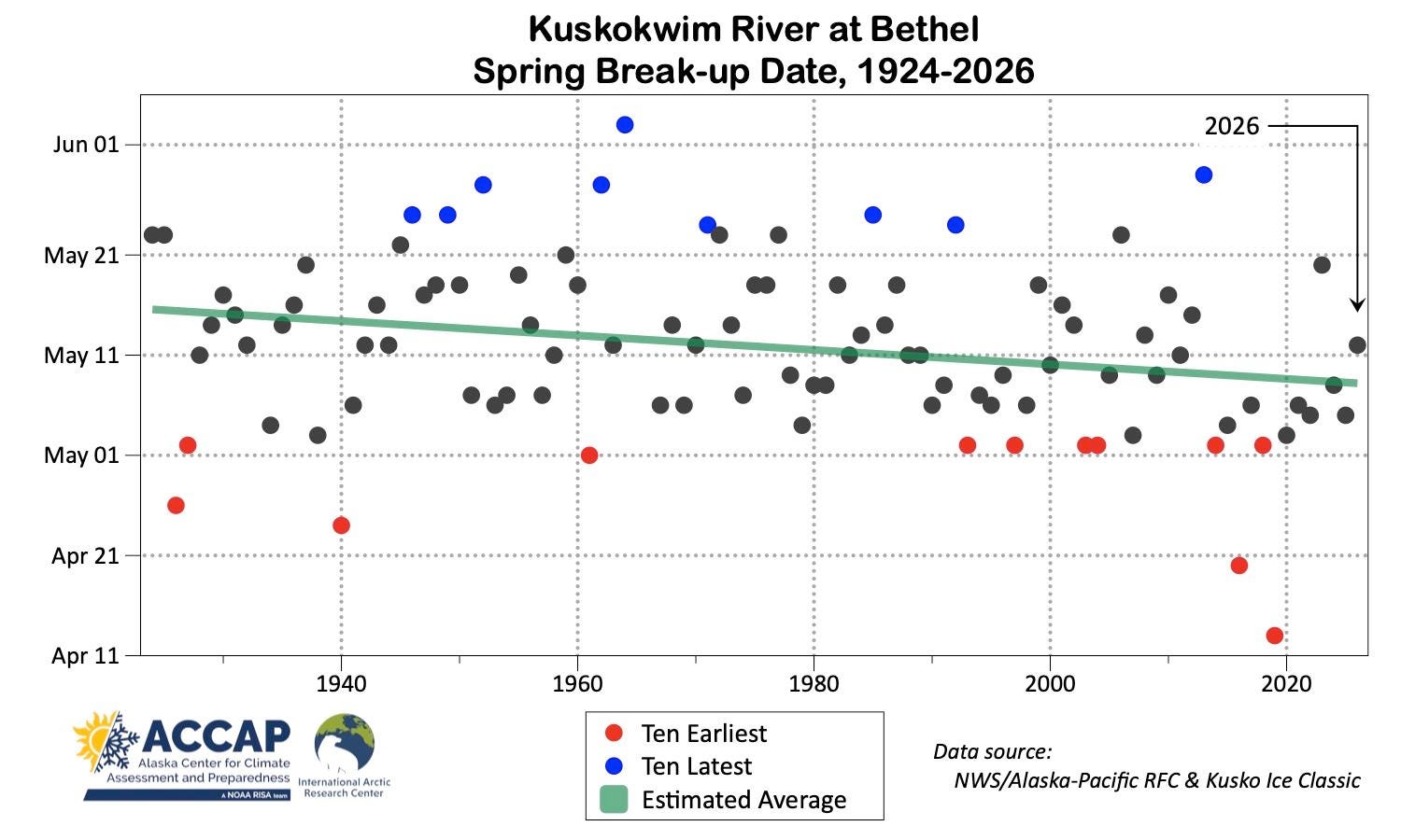
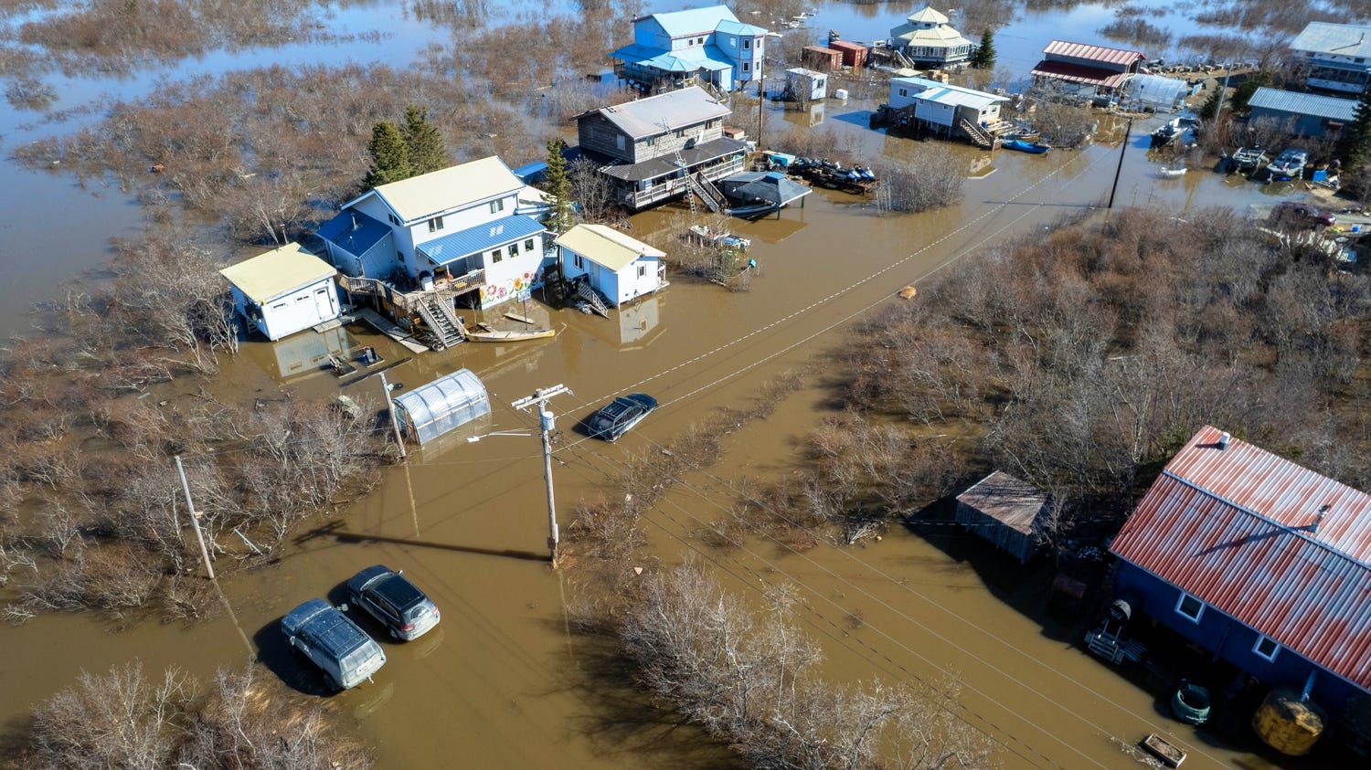
Following break-up, river levels on the Kuksokwim remained elevated for several days, resulting in mostly minor flooding at Kwethluk, Bethel (Fig. 4), Napaskiak, Oscarville and Napakiak.
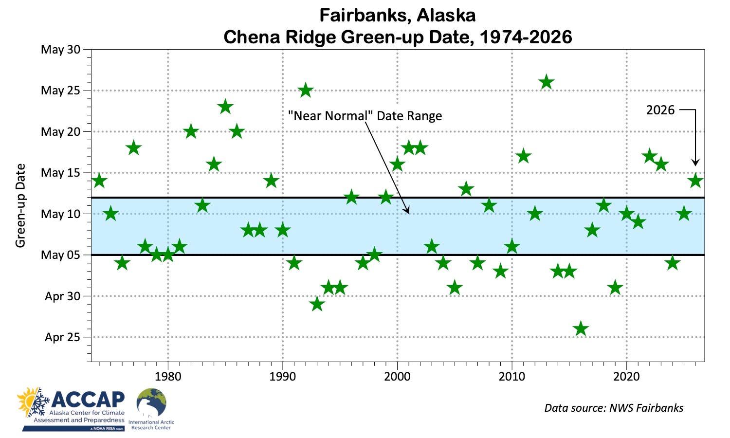
Fairbanks Green-up
Birch and aspen tree leaf-out, colloquially known as “green-up”, is an important milestone in the boreal forest ecosystem seasonal round. At least in northwest North America, this can be dramatic, with whole hillsides turning from brown to green in less than one day. Green-up is visually dramatic but is just one stage in the forest’s transition from winter to summer. Prior to green-up, sap starts to run in the trees, and tapping birch trees to make syrup, candies or even drink straight-up is a popular activity. Immediately after green-up, birch trees release pollen, which many people are quite sensitive to, and Fairbanks has the dubious distinction of recording some of the highest birch pollen levels ever measured. For more information, check out the project page at OneTree program at University of Alaska Fairbanks.
In Fairbanks, the date of green-up has been recorded for the same hillside (Chena Ridge) from the same vantage point (West Ridge at the University of Alaska Fairbanks) for more than 50 years (Fig. 5). As far as I know, there’s no other green-up time series anywhere near this long anywhere else in Alaska. Unlike spring river break-up timing, there is no significant long term trend.