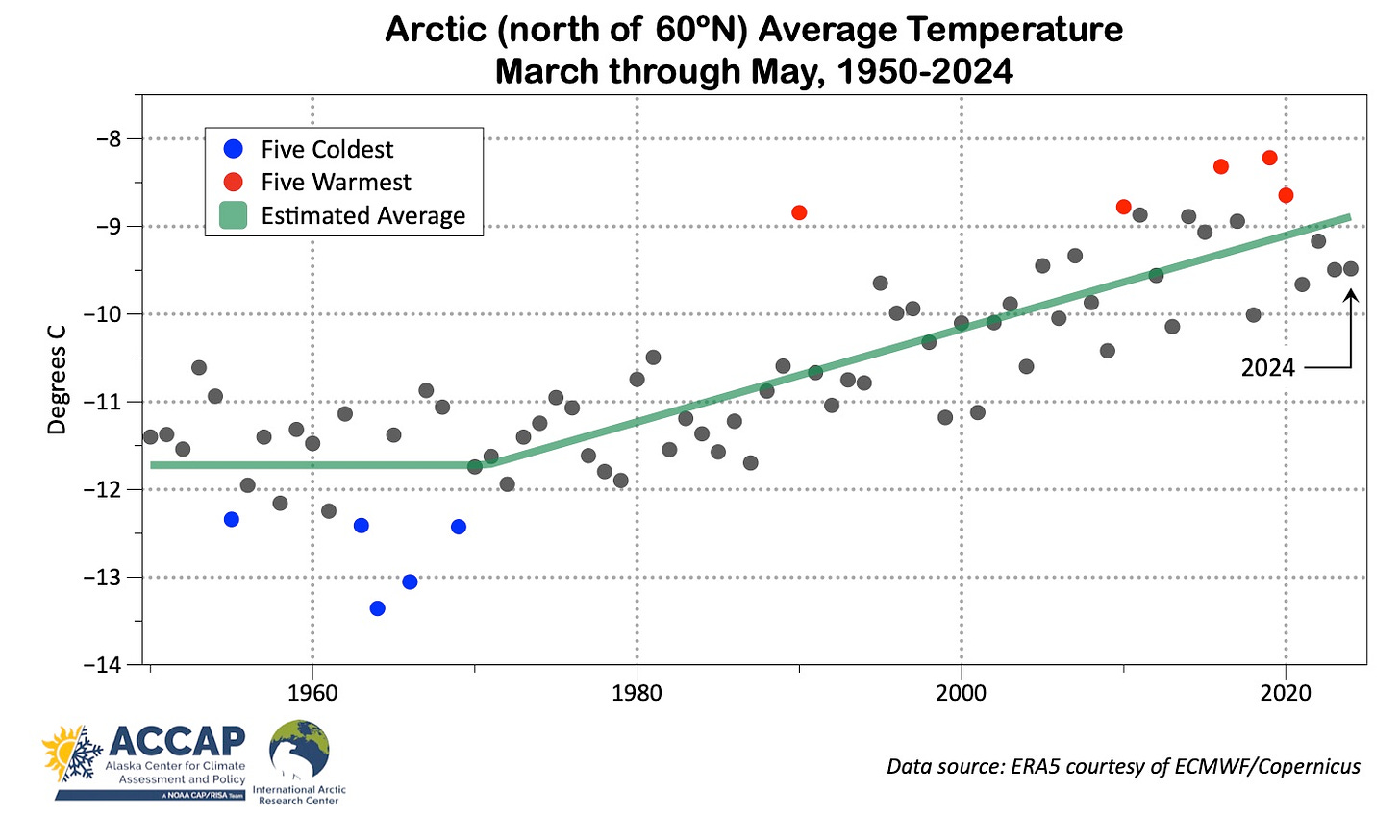
The global average temperature in May, for the 12th consecutive month, was the highest on record, but the Arctic continues to be slightly different. The Arctic as a whole, the March through May spring season average temperature was the 13th highest since 1950, effectively tied with Spring 2023.
Temperatures
Spring 2024 in the Arctic saw areas both significantly warmer and significantly cooler than the 1991-2020 normals baseline, as shown in Fig. 1. A “top three” warmest spring (since 1950) occurred in portions of Arctic Canada, northern Greenland, the Nordic Arctic and easternmost Siberia. While it was unusually cool in parts of the Russian European Arctic, nowhere had a “top three” coolest spring. For the Arctic as a whole, the March-May average temperature average 0.3°C above the 1991-2020 normal. More of the Arctic was warmer than normal than not: 58 percent area north of 60°N had an average temperature this spring above normal.

Figure 2 plots the spring average temperature time series since 1950. The step-wise linear regression estimate of the time varying average shows a 2.7°C increase in the average spring temperature since the early 1970s.

Precipitation
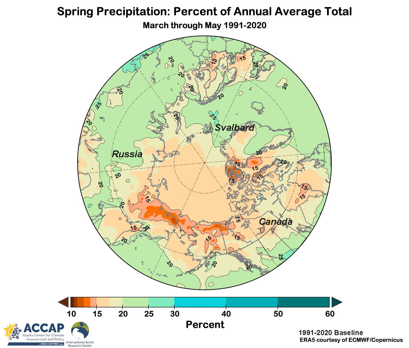
Historically, spring is the driest season of the year across a large swath of the Arctic. Figure 3 shows the March through May 1991-2020 average precipitation as a percentage of the annual total. Spring is (typically) especially dry from central Siberia eastward through Alaska and into northwest Canada, but dry areas are also found in Scandinavia. Note too that there are hardly any areas where spring precipitation typically makes up 25 percent of the annual total: if precipitation were evenly distributed throughout the year then each season would have 25 percent of the annual total.

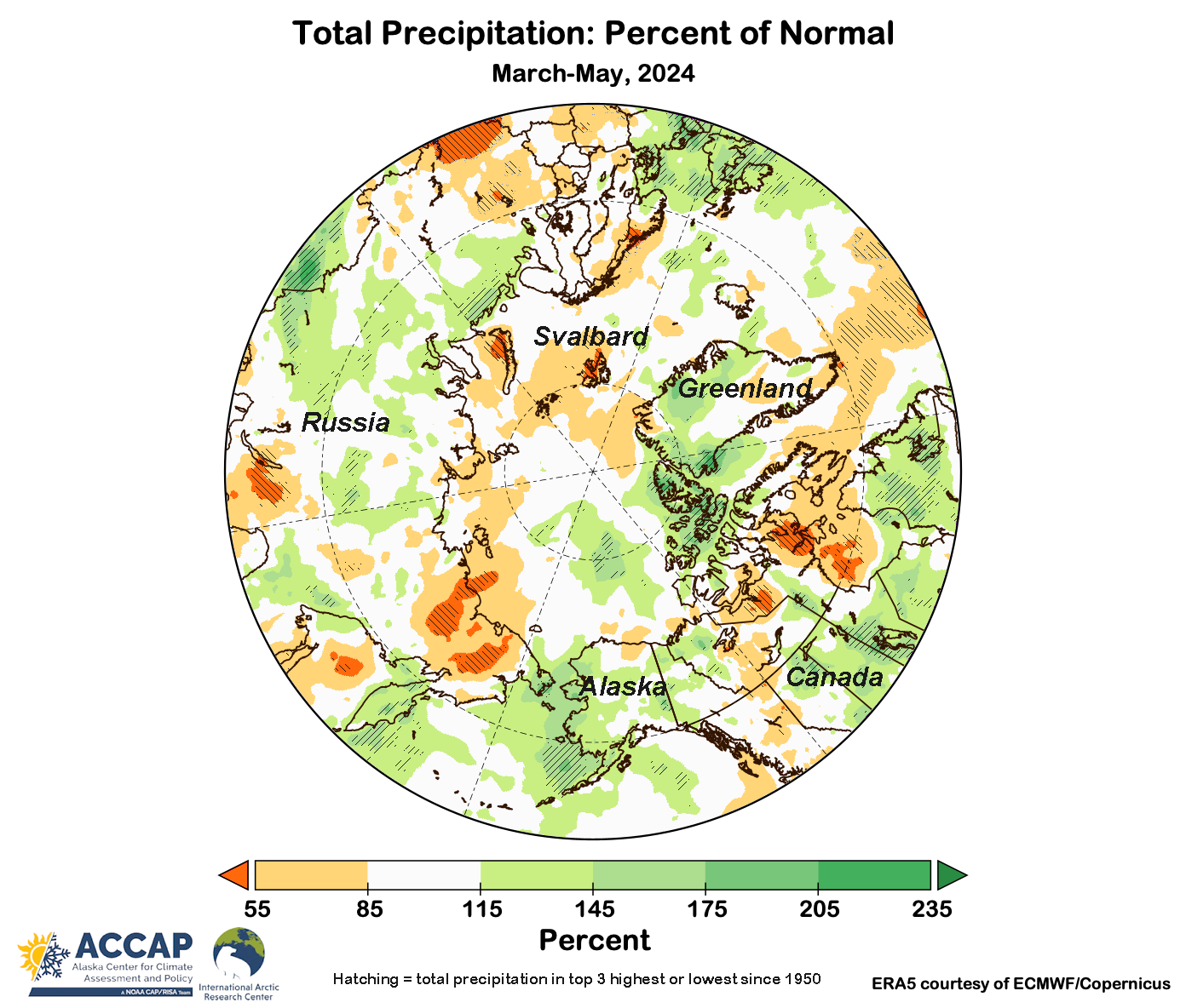
Precipitation departures are always more heterogeneous than temperature departures over comparatively short distances, even when aggregated over a season, and this is evident in Fig. 4, showing the percent of normal precipitation this Spring. Different parts of Arctic Canada had a “top three” highest and “top three” lowest totals this season.

Precipitation totals relative to normal were highest in the Canadian high Arctic and the European Russian Arctic. Significantly drier than average areas included much of the Russian Far northeast and parts of the eastern Canadian Arctic. Overall, the average precipitation for the Arctic was 101 percent of the 1991-2020 normal and ranked as the 20th highest in 1950.
Spring 2024 Circulation
Spring 2024 mid-atmosphere (500 hPa) circulation helps to explain some of the notable departures of temperatures and precipitation. A persistent cold low aloft over the Kara Sea and troughs of low pressure through the Bering Strait and from near the North Pole south into the eastern Canadian high Arctic is reasonably well correlated with the temperatures, and along the troughs precipitation was enhanced. High pressure aloft prevailed over eastern Siberia, the eastern Canadian Arctic and the Nordic Arctic, and these broadly correspond with area of below normal precipitation totals.

Alaska and vicinity
Continuing a pattern that has occurred frequently in the past year, Fig. 6 shows the coolest temperatures relative to normal in Spring were found in southwest Alaska and in the greater Bering Straits region, while eastern Interior Alaska eastward into the Northwest Territories was quite a bit warmer than average.

For southwest Alaska, this was the second consecutive chilly Spring, though in most places Spring 2023 was slightly cooler. In parts of eastern Interior Alaska and Yukon Territory this was the mildest Spring since 2019. For the political divisions, west to east, Spring 2024 average temperatures ranks since 1950:
Chukotka: 25th warmest
Alaska: 22nd warmest
Yukon Territory: 11th warmest
Northwest Territories: 5th warmest
Figure 7 shows more detail on the reanalysis-based precipitation departures for the Spring. Near to above normal precipitation in most areas in Alaska except for parts of the North Slope and southern Southeast. In parts of western Alaska and in a small area in the southeast Interior, precipitation totals were near but not quite at record high levels. Much of northern British Columbia and parts of the Northwest Territories were also quite dry relative to normal.


Thank you for the post, Rick. My understanding is that the Arctic is warming 4x faster than the global average. Is this correct? Seems like the 13th warmest spring since 1950, is cold comfort. Sorry for the pun. Permafrost melt has been happening for a number of years now. Is the Arctic still a net absorber of GHGs, or now an emitter?