


Southcentral Alaska's Mid-Winter Snow Drought

Background
The December through February 2024-25 mid-winter season brought exceptionally low snowfall to much of low elevation Southcentral Alaska. Some areas had above-normal snowfall in October and early November, and there has been snow in March, but amounts have not been excessive and don’t come close to making up for the mid-winter deficits. This post serves to document this unusual situation.
The area from the Matanuska-Susitna Valley (invariably “Mat-Su”) valley southward across greater Anchorage and the Kenai Peninsula, collectively “Southcentral”, is home to almost two-thirds of Alaska’s population. However, there are comparatively few active climate sites in the region with more than 50 years of observations, and by my count only three long-term sites with reasonably complete daily snowfall observations: Alyeska (Girdwood), Anchorage International Airport and Matanuska Experimental Farm. As a result, given the distances involved (it’s more than 300 miles from Talkeetna to Homer) and the roles of Cook Inlet and the multiple mountain ranges influencing weather and climate, snowfall at the seasonal scale is poorly documented. The typical snow season at low elevations in Southcentral extends from October into April, though in some years there is no significant snow until November or after early March (accumulating snow does infrequently occur in September and May, especially from Anchorage northward).
Mid-winter snow
Figure 1 plots the total mid-winter snowfall reported from Anchorage Airport 1953-54 through 2024-25. There is a (marginally) statistically significant trend toward higher mid-winter snowfall: this was the first really low snow winter since 2015-16.
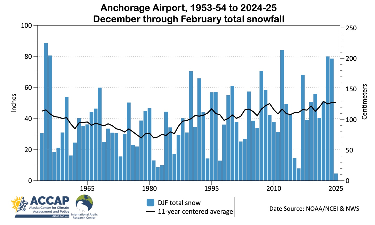
Figure 2 plots the percentage of the total seasonal (September to May) snowfall that falls in the mid-winter season at Anchorage Airport. Based on the 1991-2020 NOAA/NCEI normals, mid-winter snowfall accounts for about 56 percent of the entire seasonal total, but has ranged from greater than 80 percent in a few seasons to as less than 10 percent this winter (we won’t have the final percentage until the end of May).
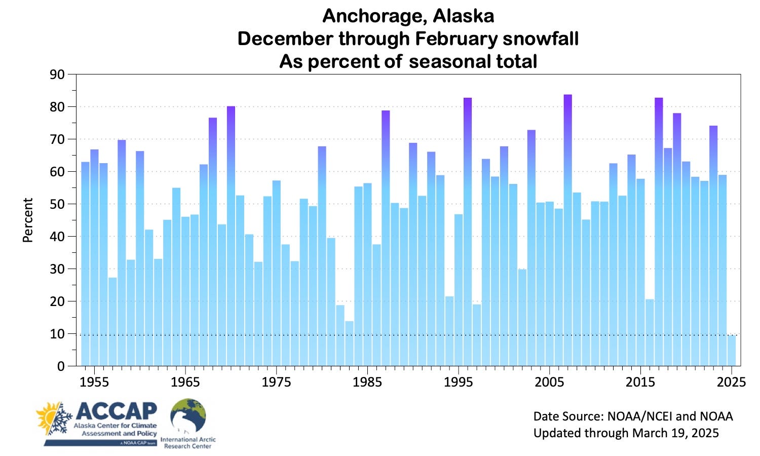
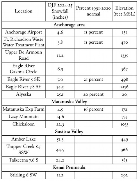
Table 1 lists snowfall totals from National Weather Service and CoCoRaHS sites between Talkeetna and Homer with largely complete data for the 2024-25 mid-winter season. The numbers pretty much speak for themselves, though the paucity of observations means that small, or even not-so-small scale detail is unreported, e.g. there’s just one December-February snowfall total (from east of Soldotna) on the entire Kenai Peninsula.
For the three locations with 50 plus years of snowfall data, both Anchorage airport and Alyeska had the lowest mid-winter totals, while the Matanuska Experiment Farm was third lowest, with 1981-82 and 2015-16 having lower reported totals.
Snow Depth and Snowpack
Anchorage airport snow depth (as measured at the NWS Sand Lake office) was one inch or higher on 56 days this past mid-winter season (the 1991-2020 median is 90 days, i.e. every day). This is not the fewest mid-winter days with measurable snow: the winter of 1985-86 had only 19 days. However, the reported snow depth of “trace” every day in February 2025 made this the first mid-winter month in Anchorage climate history that had no days with at least 1 inch snow depth.
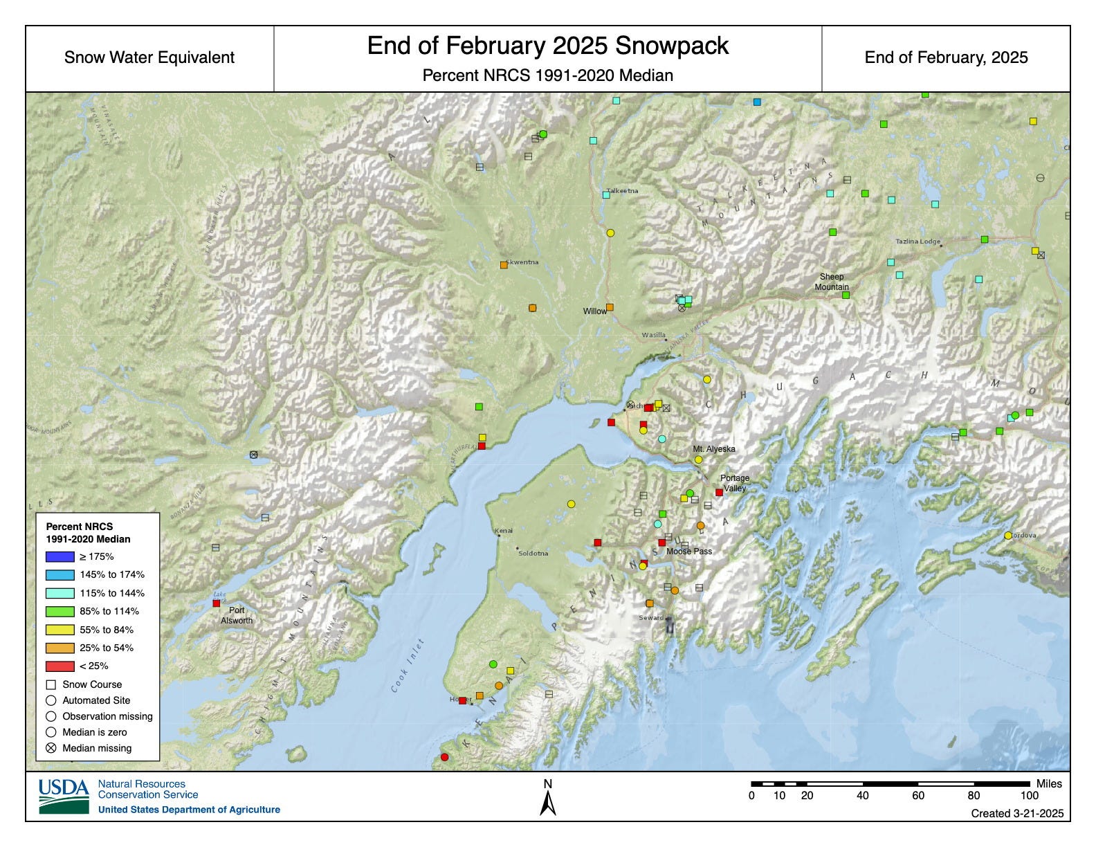
The USDA/Natural Resources Conservation Service SNOTel (automated, near-real time data) and snow course (once a month data) networks, with sites at both low and moderate elevations, provide observations of snowpack snow water equivalent (the amount of water in the snowpack). Figure 3 shows the percent of median (1991-2020 baseline) snow water equivalent at the end of February. While there is a lot of variability, we can make a few generalizations. From Talkeetna northward and in the Talkeetna mountains, snowpack snow water equivalent was above normal. Low elevation snowpack from the Willow area southward was very low (or non-existent). The situation in the Chugach and Kenai mountains was more complex, but most sites above 1200 feet elevation had more than 50 percent of the median snow water equivalent, and a few locations had above median snowpack, e.g. Indian Pass in the Chugach and Turnagain Pass and Summit Creek in the Kenai mountains.
Why so low?
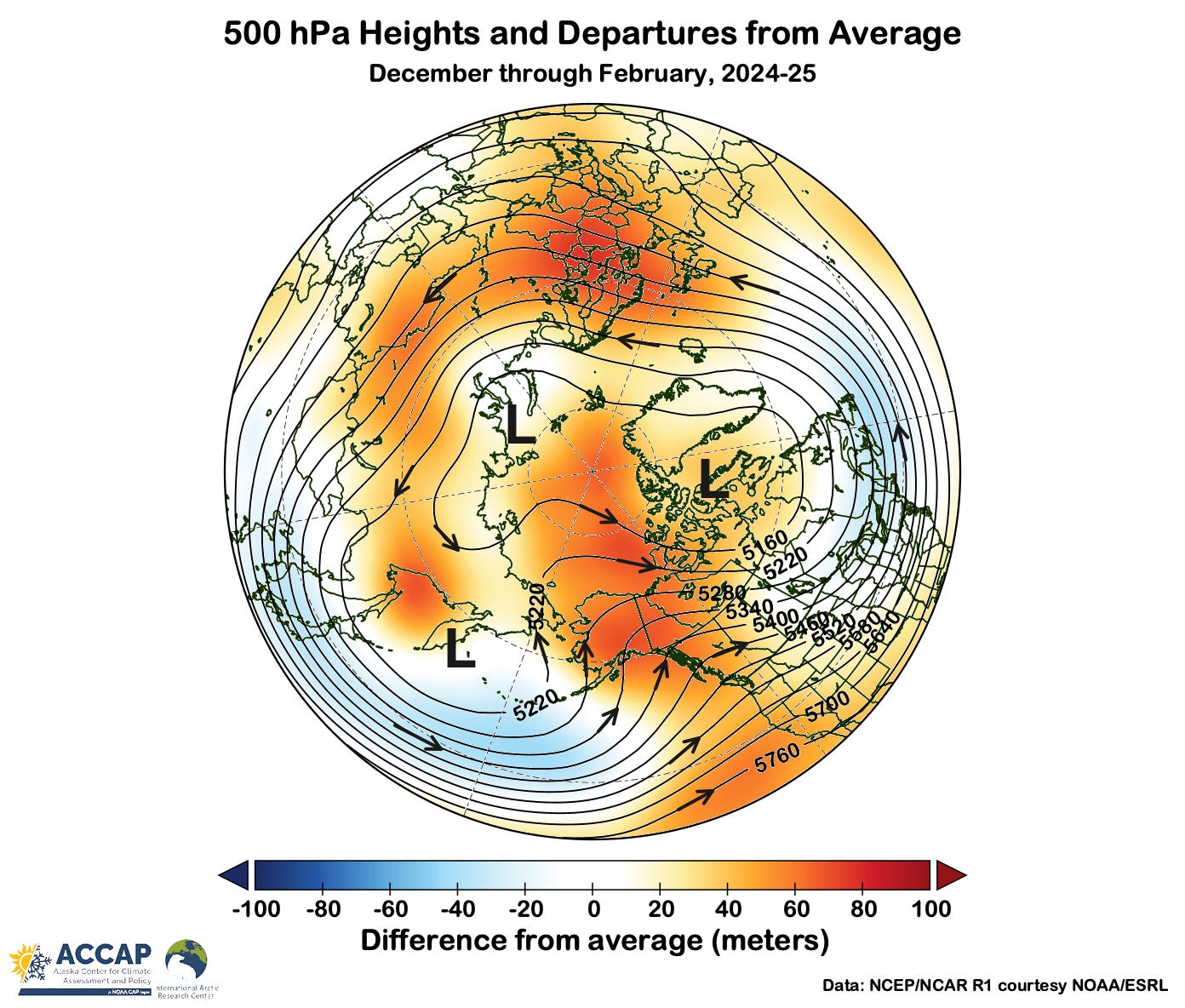
A full diagnostic study of the drivers of weather and climate conditions observed during the 2024-25 mid-winter season is beyond the scope of this post, but the mean mid-atmosphere flow pattern shown in Fig. 4 is instructive. In the three month average, low pressure was anchored just east of Kamchatka and south to southwest winds prevailed across all of Alaska. This is a classic “warm winter” pattern for Alaska and similar to the mid-atmosphere patterns during mid-winters in 1985-86, 2002-03 and 2015-16.
As always, a very informative article. Thank you! One minor detail: it is called the “Matanuska Experiment Farm.” A common mistake.