


January 2023 Climate Review
Temperatures and Sea Ice

We start the monthly review here with temperatures and sea ice. Precipitation and snowfall/snowpack will be most helpfully discussed once the ERA5 reanalysis for January becomes available on February 6 or 7. However, based on what reliable station specific data has been reported thus far, unlike December, for the most part precipitation and snowfall were not dramatically far from normal in most of Alaska.
Temperatures
The first look at January temperatures in Fig. 1 reveals a very unusual pattern: nearly everywhere in Alaska was significantly warmer than normal. Because of Alaska’s size, a east-west split in cold seasons departures is common (reflecting variations in storm tracks); a north-south split is less common but occurs on occasion, e.g. last winter. Mid-winter temperatures can vary dramatically even at the monthly scale, so even though some places were ten or more degrees (F) above normal, no place had a record warm month and most long term climate sites were not even in the top ten. In the eastern Interior and Southeast Alaska January’s mild weather was a significant flip from December, while on the North Slope it was “more of the same”. Temperatures averaged closer to normal on the Bering Sea coast, where during the third and fourth week of the month there was an intrusion of colder air from the Russian far east.
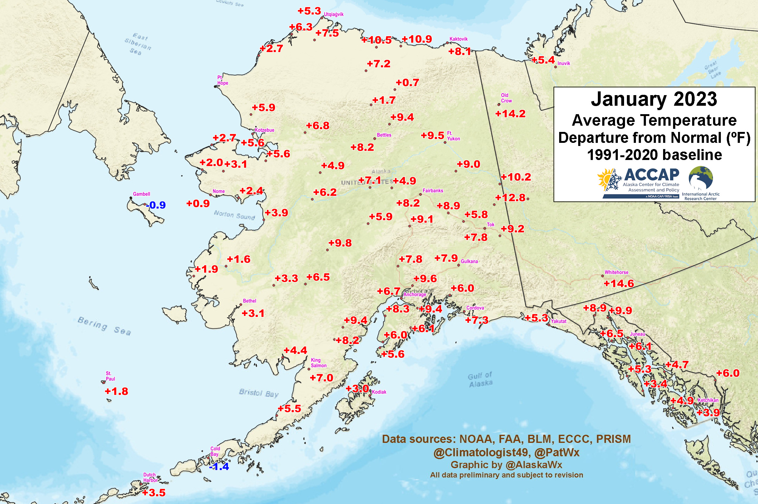
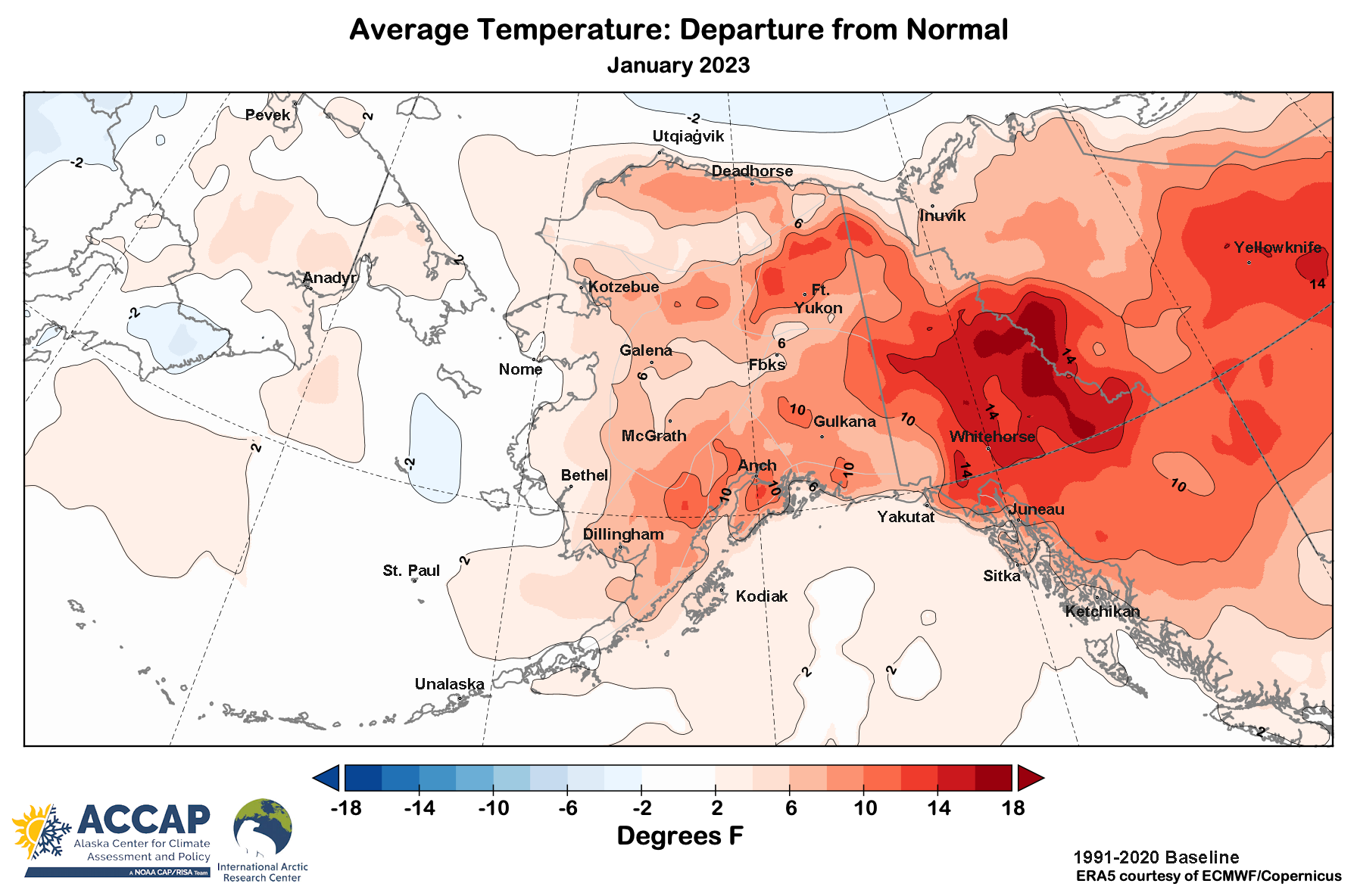
In many areas there was a real lack of severe cold. The lowest reported temperature in the state was -48F (-44.4C) from the NWS cooperative observer outside of Manley Hot Springs. [Feb 02 update: the Climate Reference Network site in Nowitna National Wildfire Reguge reported a low of -50F (-45.6C)]. Only three Januarys in the past 40 years have had a higher state-wide low temperature. Fairbanks Airport had just one day with a low temperature of -20F (-28.9C) or lower. Only three years in the past 115 have not had a January minimum temperature at least that low. Anchorage Airport’s low of of -2F (-18.9C) was the highest January minimum since 2018. In Southeast Alaska the mildest places saw hardly any subfreezing weather. At Sitka Airport the monthly low temperature was just 31F (-0.6C). In the past 75 years only January 1985 had a higher minimum temperature. February 8th addition: Figure 1a shows the January temperature departures from the ERA5 reanalysis. The agreement this month with the available station level data is quite good. This really highlights the widespread warmth and the extreme of the extreme values over the Yukon Territory and northern Southeast Alaska.
Sea Ice
Sea ice extent in the Bering Sea expanded steadily past mid-month and briefly reached the 1991-2020 median around January 23th (Fig 2). Thereafter a return of south winds and mild temperatures to the region pushed the ice edge northward a bit and there was some sea ice loss near the Alaska coast Kuskokwim Bay southeastward, with extent decreasing about 11 percent the last six days of the month. For the month as a whole, the average extent was 10 percent below the 1991-2020 median. Fig 3. shows the National Weather Service Alaska Region sea ice concentration analysis for January 1st (left) and 31st (right), showing the overall change during the month.


Sea ice thickness, stability and quality are important factors for coastal communities and people working on the ice. Unlike sea ice extent, reasonably reliable sea ice thickness has been available through satellite-derived products only in the past 20 years or so, and even shorter for reliable estimates of thin (less than one meter) ice thickness. Fig 4. shows the difference in thickness for the last week of January compared to the same week last year (only shown where ice was present in both years). This graphic uses a product that combines ice thickness estimates from two different satellites to provide a unified, reliable sea ice thickness product and is courtesy of the Alfred Wegener Institute. It’s clear that ice at the end of January 2023 in the Bering and Chukchi Seas is about the same thickness or thinner than this time last year, with significantly thinner ice in Kotzebue Sound and nearshore from Point Lay to Utqiaġvik. Thinner ice this year is also evident in the nearshore Beaufort Sea from Kaktovik eastward. Of course, there’s still time left this season for ice to thicken up, but the clock is ticking, especially in for the Bering Sea.
