December weather and climate offered up something for everyone in Alaska (okay, except for sunshine), but snow and rain were especially prominent.
Temperatures
Average temperature departures in December (Fig. 1) showed a pattern that was common in 2023, with above normal temperatures stretching from the North Slope south across the eastern Interior and into Southeast Alaska. At the same time, much of Southcentral and southwest Alaska was colder than normal. And as happened earlier in the year, some the warmth was close to record levels: Utqiaġvik reported the third highest December temperature in the past century and Sitka the fourth highest (since 1947). While southwest Alaska had the coldest December since 2012, and St. Paul Island set a daily record low temperature on Christmas Day, none of monthly averages were anywhere close to records. Another interesting feature of the month was late arrival of deep cold: the first -40F/C of the winter season in Alaska was not recorded until Christmas Day, and that was in the upper Kuskokwim valley and not, as often happens in the cold season, the the Fortymile county or upper Yukon Valley/eastern Brooks Range. Statewide, the highest reliable temperature in December was 57F (13.9C) at Metlakatla Seaplane base (southern Southeast) on December 29th, while the lowest was -46F (-43.3C) at Nikolai (southwest Interior) on December 26th.

Precipitation and Snow
As always, precipitation totals relative to normal (Fig. 2) varied far more over short distances than temperatures, with terrain playing a controlling factor in the small scale variation. Southeast Alaska saw above to much above normal precipitation totals, with some places reporting top five highest totals, mostly the result of very frequent rain. At Sitka, 26 days in the month had measurable rain, the most such days in December since 2006. The high totals extended westward to eastern Prince William Sound as well as the Anchorage and Mat-Su valleys, but the east side of the Kenai Peninsula and Kodiak Island had below normal totals. Most of the Interior except for the Southwest had above normal precipitation. Western Alaska and the North Slope had mixed departures.

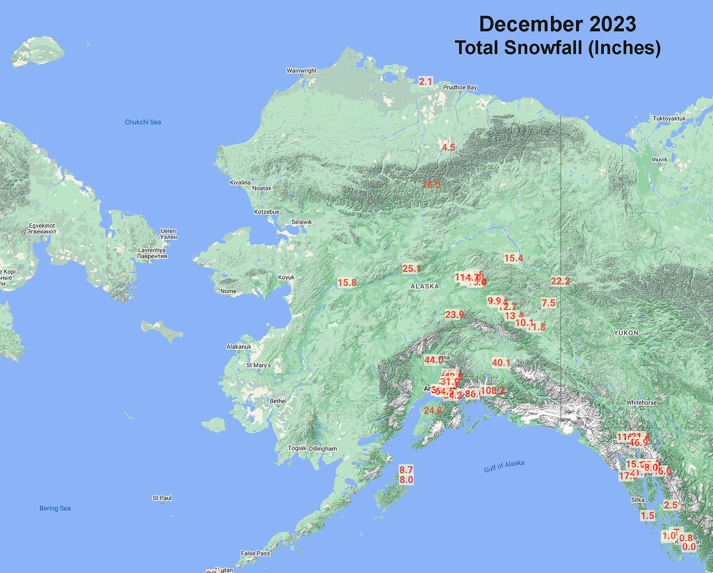
Except in Southeast and Gulf of Alaska coastal locations, snowfall in December, such as there are observations (Fig. 3), generally followed precipitation in terms of totals relative to normal. Anchorage Airport snowfall total of 39.0 inches was the third highest December total on record. Coming on the heels of the snowiest November, the September through December snowfall total of 79.5 inches is the highest “early season” total. The NWS cooperative station at Glennallen reported over 40 inches of snow, which is the second highest monthly total of record. The only snowier month was December 2022. The high snowfall on the coastal side of the Alaska Range created multiple avalanche hazards the second half of the month (some details in my post on 2023 high impact events, found here).
Other high totals include (none of these are December records):
Jan 09 update to add Main Bay:
Main Bay (Prince William Sound) 123.0 inches (312.4cm)
US Customs Haines Highway Mile 40: 116.8 inches (296.7cm)
Valdez: 108.2 inches (274.8cm)
Girdwood: 84.2 inches (213.9cm)
Anchorage Hillside (upper De Armoun Road): 64.5 inches (163.8cm)
Sea Surface Temperatures
Ocean surface temperatures beyond the sea ice edge (Fig. 4) were generally near to above in both the Bering Sea and Gulf of Alaska, though not as far above normal as in November. This is common in the winter as near surface water becomes increasingly well mixed due to storminess.

Sea Ice Extent
Sea ice extent increased rapidly after the first days of December (Fig. 5) as persistent northerly winds prevailed over the southern Chukchi and northern Bering Seas.

By New Year’s Eve, sea ice extent in the Bering Sea was the highest for that point in the season since 2012. Given the late start to ice formation, most of this ice is still quite thin and vulnerable to rapid loss and retreat if the weather pattern changes in early 2024.


