


Alaska’s Really Cold Start to February
Unusual for so late in the winter

Just a quick post to highlight the deep cold over portions of the Alaska mainland to start February, with temperatures very low for this late in the winter. I’ll have a more complete summary after the cold breaks and more complete information becomes available.
Southcentral Alaska
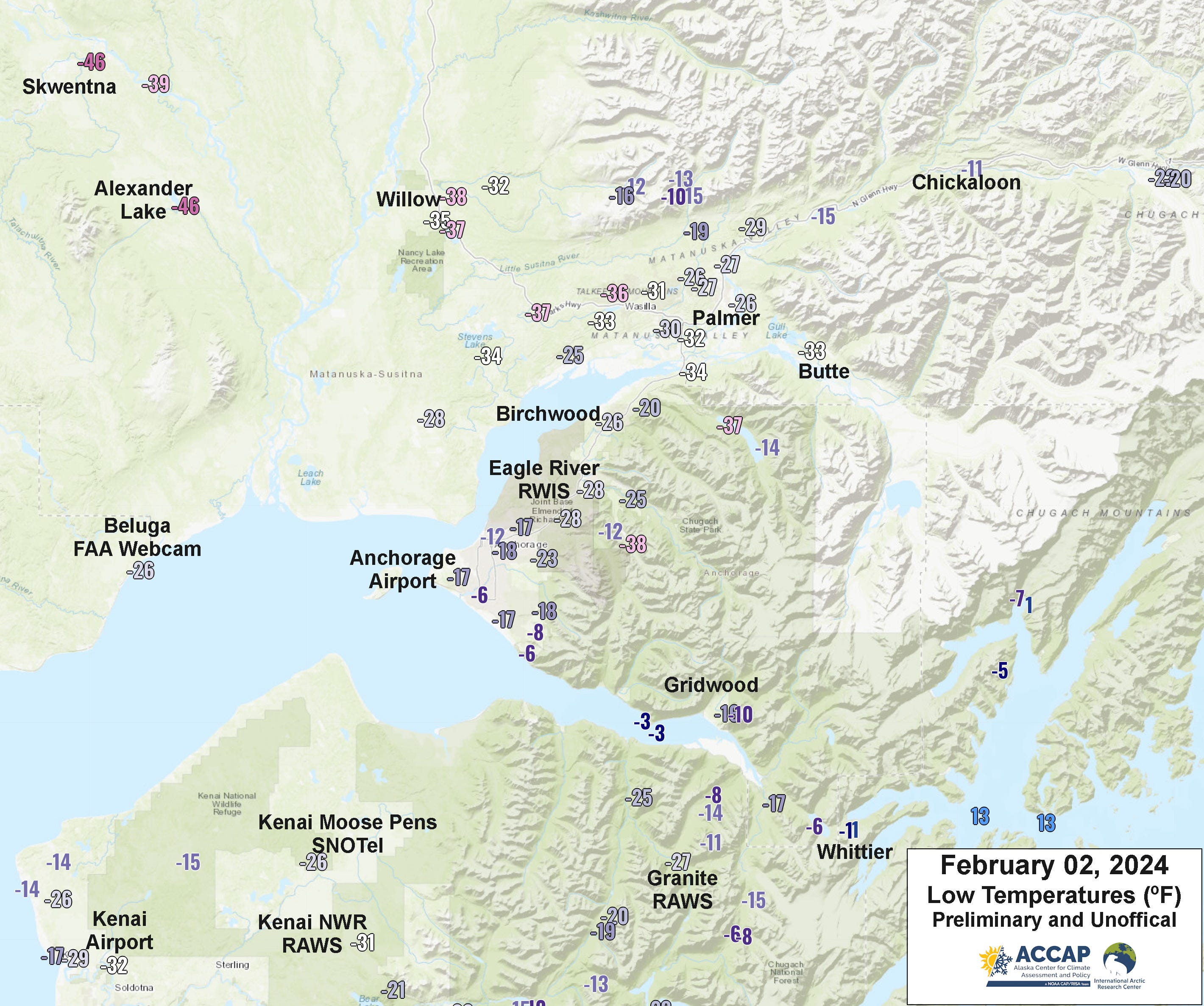
Starting off in Southcentral (Fig. 1), Anchorage airport fell to -17F Friday morning, but even more impressive was the afternoon high temperature of -6F. This is the lowest daily high temperature since January 2009 and the lowest this late in the winter since February 1999. With the high temperature at Anchorage Airport of -2F on Thursday, this is the first occurrence of back-to-back days with high temperatures 0F or lower since January 2017. The temperature of -38F southeast of Eagle River is accurate. This location is along the South Fork Eagle River at about 2200 feet MSL. So far the lowest temperature reported in the immediate Anchorage area at low elevation is -33F at the old Ft. Richardson airstrip (now part of JBER) on Thursday. Talkeetna (just off the north edge of Fig. 1) set a daily record low for February 1 of -39F and this is the lowest temperature since February 1999 (though it did reach -38F in January 2017).
Southcentral Alaska
Starting off in Southcentral (Fig. 1), Anchorage airport fell to -17F Friday morning, but even more impressive was the afternoon high temperature of -6F. This is the lowest daily high temperature since January 2009 and the lowest this late in the winter since February 1999. With the high temperature at Anchorage Airport of -2F on Thursday, this is first occurrence of back-to-back days with high temperatures 0F or lower since January 2017. The temperature of -38F southeast of Eagle River is accurate. This is along the South Fork Eagle River at about 2200 feet MSL. Talkeetna (just off the north edge of Fig. 1) set a daily record low for February 1 of -39F and this is the lowest temperature since February 1999 (though it did reach -38F in January 2017).
Central Interior
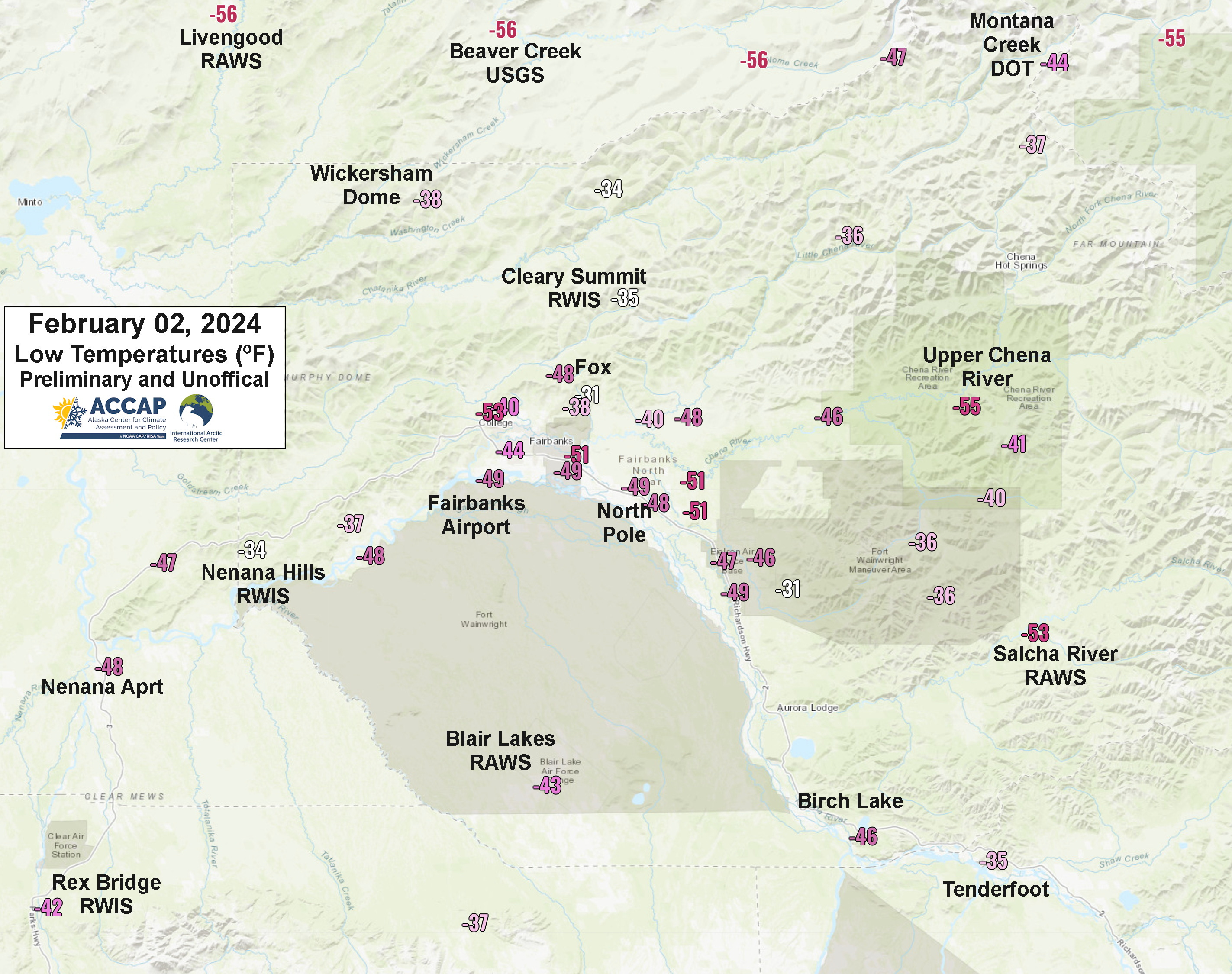
In the Fairbanks area (Fig. 2), valley low temperatures were a bit lower than January 26-28, while locations at elevation were generally a few degrees higher. At Fairbanks Airport, the low temperature Friday was -49F [update: late Friday evening temperature hit -50F] and Fairbanks urban area also had the first widespread dense ice fog since January 2017. But like the Anchorage area the really outstanding feature was the high temperature on February 2. The calendar day high temperature at the airport was -38F, which occurred shortly after midnight (the afternoon high was -39F). This is exceptionally low for this late in the season: only four days since 1905 have had a high temperature lower than -38F this late in the season, the most recent being February 4, 1999, when the high temperature was -42F (this is also the latest date in the winter with a high in the -40s).
At Fort Wainwright, the airport is close to the Chena River and being on the east side of town, is often colder in these situations than Fairbanks International. February 2 high temperature was -39F and low -52F. Eielson Air Force base reported February 2 temperatures of a high of -37F and a low of -49F. Temperatures in the Delta Junction area (off the southeast edge of the graphic) were widely in the 40s and 50s below, and this was the coldest weather since January 2017.
At age 64 I've kind of been enjoying dressing up warmly and going for nice afternoon walks at 30-40 below in the hills. It reminds me of exactly 40 years ago when I was first experiencing 40-below weather in Great Falls, Montana, and somehow seemed drawn to it. Of course, back then I never even thought of using hand warmers, and now I'm decked out with hand and toe warmers and more clothes than I used to wear back then.
But, at this older age, I tend to worry more about the "what ifs" related to heating. Fortunately we have redundancies, but I was pretty surprised just a few minutes ago to use the oil dipstick and find that we used approximately 8.0 gallons per day since I last measured on 12 January. We've had our pellet stove running almost non-stop upstairs, so only minimal oil usage there.
Prior to this, in the past 15 years, the most we ever used was about 6.3 gallons per day over about ten days at end of Dec 2009, beginning of Jan 2010. We were heating the entire house with oil then. Of course, measuring with the dipstick is probably subject to a +/- 5-10 gallon reading error.
Do you have recommendations for temperature records for these areas at elevation (e.g. 1,173 MSL for us) that date back 15-20+ years? It would be interesting to compute heating degree days at elevation, as well as down at the airport. I'm wondering just how much this absence of inversion has added to the heating. After a week or so sitting mostly around -30 to -40 up here, I have to remind myself that up until this past week, we hadn't seen anything this cold for our 15 years here.