
Alaska's Chilly 2026
The first half of the the year has been cool. But why?

Many folks in Alaska have remarked on the lack of sustained warm weather this summer, and indeed how it’s been persistently cool since early December 2025. This post gets to some of the context of “why has it stayed cooler than normal for so long?”
What’s Happened
Setting the stage, temperatures the first half of 2026 averaged below normal over most of mainland Alaska (Fig. 1), with maximum departures running from the central Interior southwest through the upper Kuskokwim River valley and then south to the upper Bristol Bay area. There were very small areas near Fairbanks and around Iliamna Lake, totaling just 0.3 percent of the state, where the January though June average temperature was in the “top three” lowest since 1950. Overall, this was the coolest January through June for Alaska since 2012 and the second coolest in the 21st century, though in a measure of how much warming there’s been, it’s not even in the top 20 coolest since 1950.
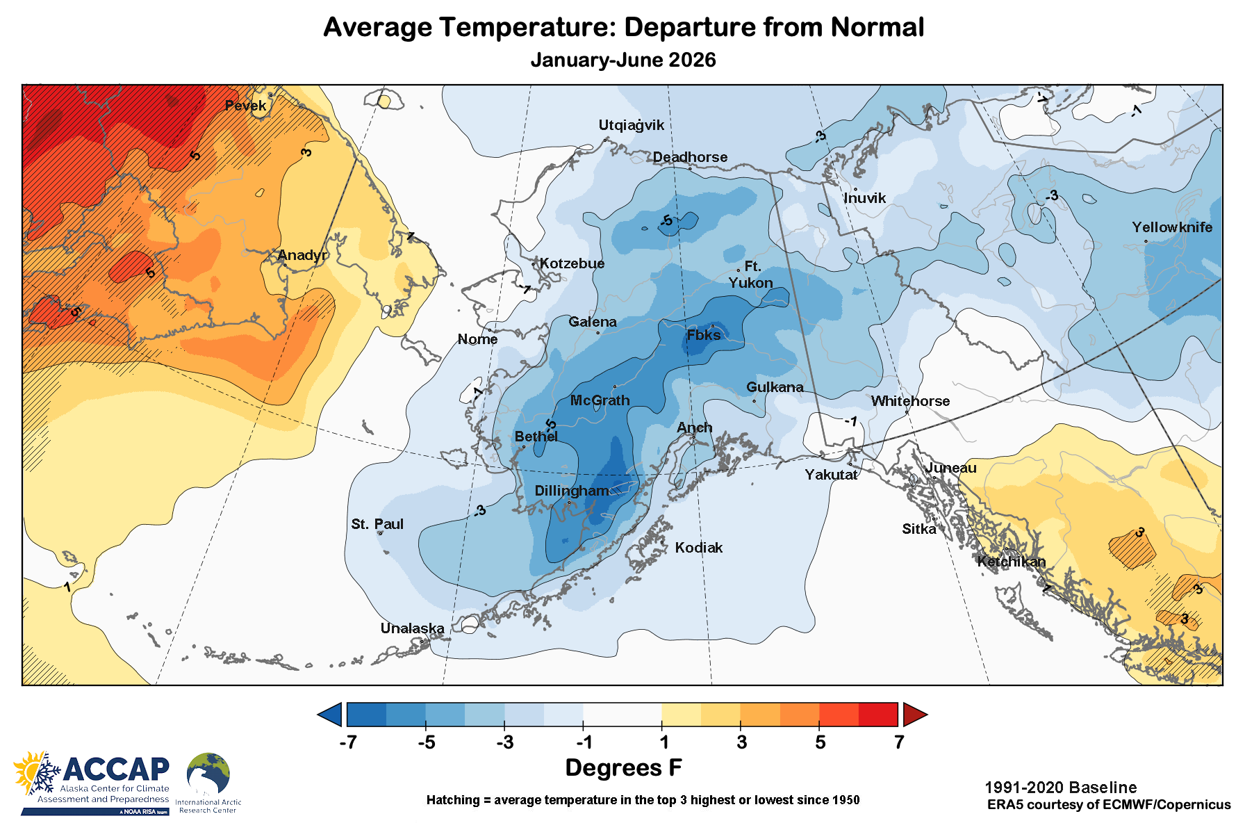
For Alaska overall, every month December 2025 through June 2026 had an average temperature below the 1991-2020 baseline normal, though April and June were very close to normal (only 0.3°F below normal). The last time there was this long a run of months below normal was the eight months August 1975 through March 1976.
Looking at the bigger picture (Fig. 2), the first half of 2026 was quite chilly over not just mainland Alaska but other high latitude areas, especially western and central Arctic Canada. Unsurprisingly, some other areas were much warmer than normal, including most of the Russian far northeast and Svalbard. Over Arctic lands (all land north of 60°N), the warm and cool areas almost exactly balanced out, with the January through June average temperature 0.2°F above the 1991-2020 baseline, which was only the coolest since 2022.
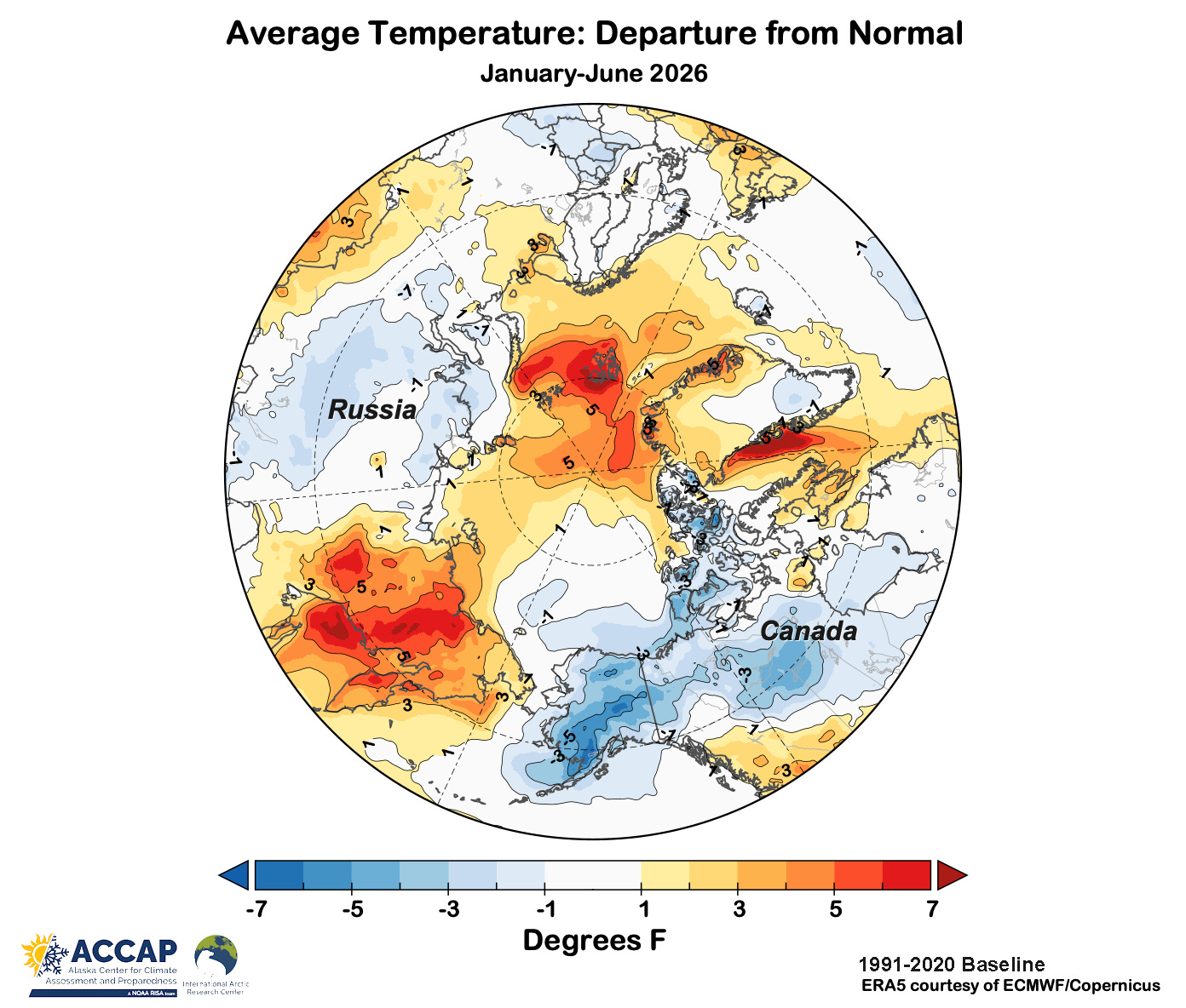
Looking just at the extremes, about 0.7 percent of the Arctic had an average temperature for the six month 5°F or more below the 1991-2020 normal. Both 2021 and 2012 had a larger area that was that cool for the first six months of the year. In contrast, about 6 percent of the Arctic had temperatures average 5°F or more above normal. This pan-Arctic viewpoint suggests that nothing fundamental has changed: warm areas are far more expansive than cool areas, as is the case these days almost every month/season.
Historical perspective
The Alaska-wide 12-month running average temperature (Fig. 3) since 1950 shows that rapid changes (both downward and upward), which occur with sustained large scale weather pattern shifts, have happened numerous times in the past 75 years. The dips in 1970-71, 1981-82, 1998-99 and 2019-20 were all larger than the current drop (though of course the 2025-26 drop could increase).
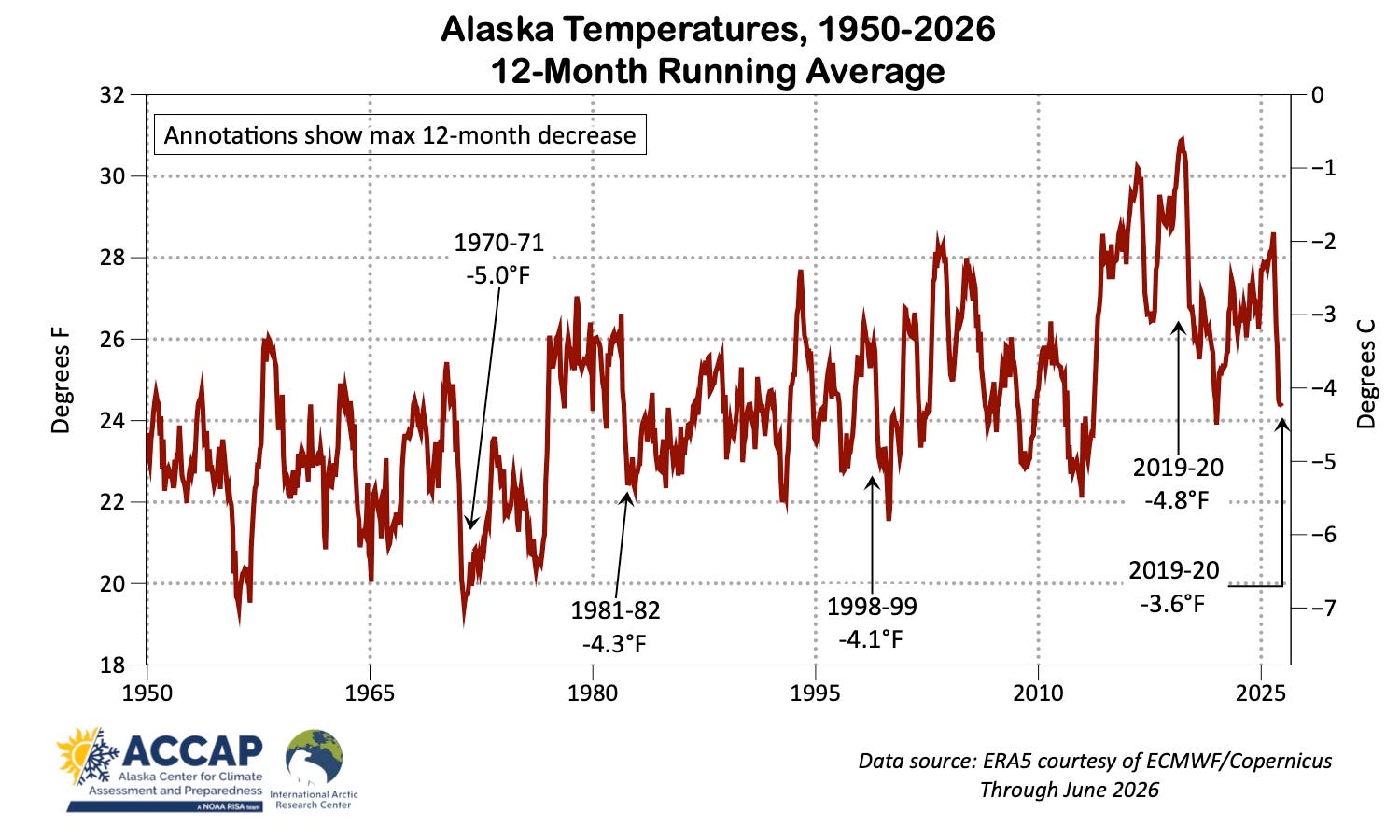
This strongly suggests that current prolonged coolness is not the result of a unique convergence of circumstances but rather the result of unusual but recurrent set of factors.
Why so chilly?
Large scale
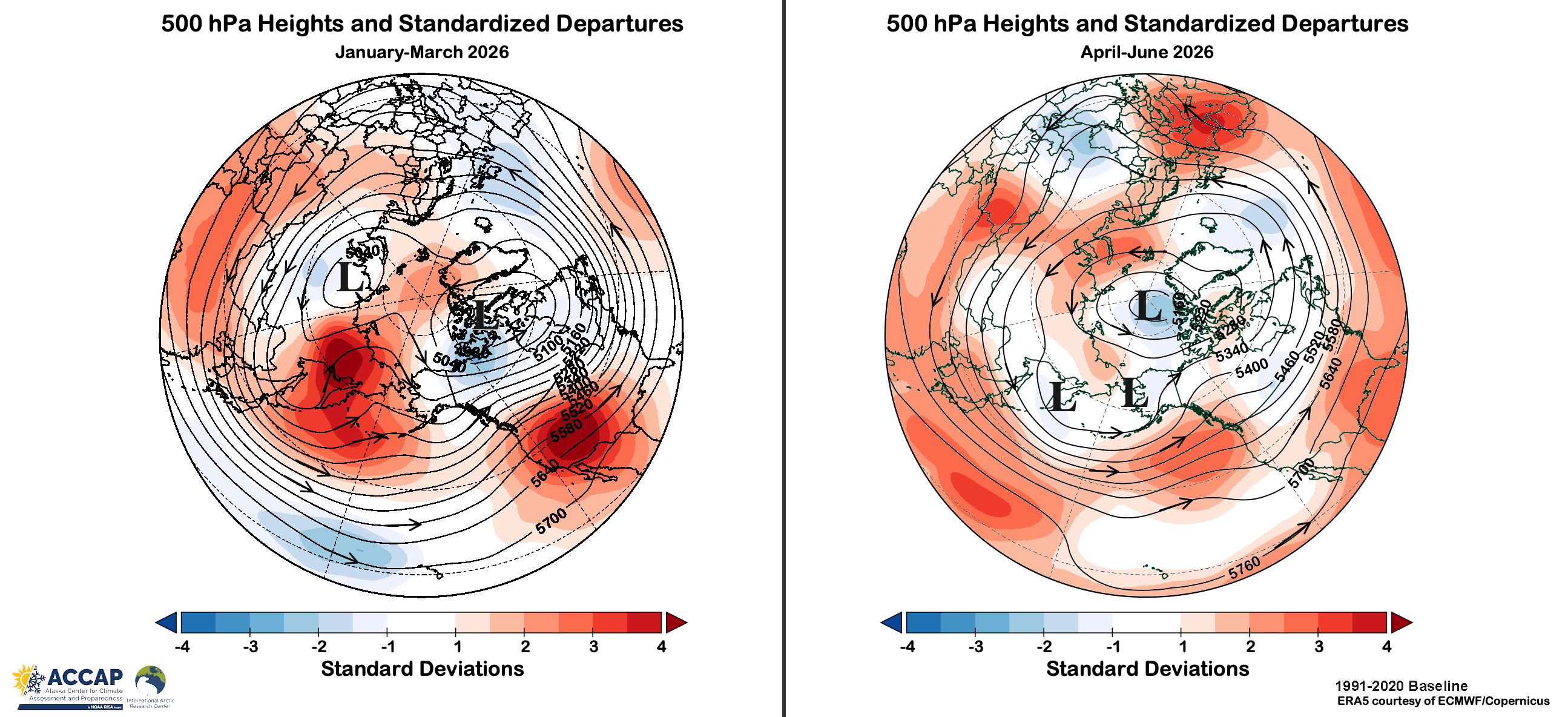
The average mid-atmospheric flow patterns for January-March and April-June around the Northern Hemisphere were quite different (Fig. 4), but both supported below normal temperatures during their respective seasons across most of mainland Alaska: neither pattern is notably cool for Southeast Alaska.
During the late winter (January-March) season, exceptionally strong high pressure in the middle atmosphere over the western Bering Sea and Russian far northeast resulted in cold northwest flow aloft across mainland Alaska. As important as the source region for the air, this pattern also supports high pressure at the surface, and associated clear skies allow for strong valley based surface temperature inversions to set and persist. For the April through June late spring season, low pressure aloft dominated most of the Bering Sea, with higher pressure over the northeast Pacific Ocean west of British Columbia. This pattern is more supportive of “not warm” rather than especially chilly for Alaska, so it’s no surprise that two of the three late spring months averaged close to normal.
Regional factors
Regional factors have certainly played a role in the cool weather around Alaska. Most obviously, the extensive sea ice in the southeast Bering Sea in March and early April primed sea surface temperatures in the region for a cool late spring and early summer, and this is reflected in the January through June sea surface temperature departures from the 1991-2020 baseline normal (Fig 5). Far eastern Gulf of Alaska sea surface temperatures were slightly above normal from Baranof Island southward but otherwise near to only slightly below normal.
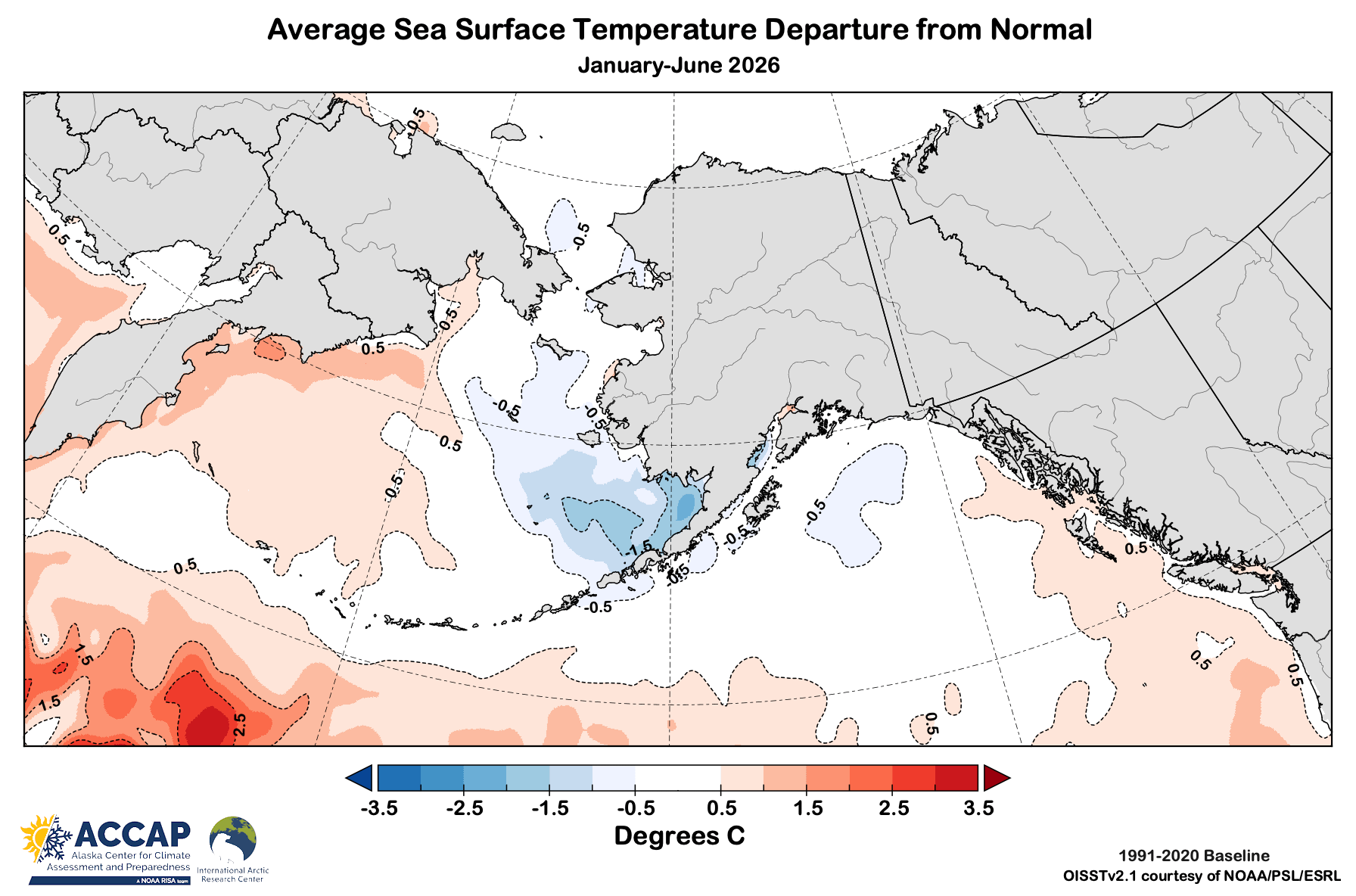
Snow melt was a little later than usual over most of mainland Alaska south of the Brooks Range, but was more significantly delayed relative to normal in the Brooks Range and on the North Slope. This is of course is another reinforcing process: low temperatures support maintaining snow pack later in the spring, while a solid snow pack suppresses surface temperatures compared to bare ground.
Bottom line
Alaska’s cool weather since December doesn’t reflect any fundamental change in the warming high latitude environment. Rather, intrinsic variability in the ocean-atmosphere system (variations unrelated to changes in drivers like solar heating or greenhouse gases increases), combined with regional/seasonal scale positive feedback loops, e.g. unusual early spring sea ice → cooler early summer sea surface temperature, came together to produce a short-term downturn in temperatures across the region. Probably sooner than later, the dominate weather pattern will shift and it will be Alaska’s turn to be unusually warm while other parts of the Arctic are cooler.