
Alaska-style March Madness
Unusually cold and regionally snowy

March has been very cold across much of Alaska. Following an usually cold winter, the continuing wintery temperatures, and the bountiful snow in in Southeast, means that lots of folks are even more ready than usual for significantly milder weather to go with the rapidly lengthening daylight.
Temperature departures for the first half of the month (Fig. 1) based on ERA5 Land reanalysis show the coldest area relative to the 1991-2020 baseline normal was in the upper Bristol Bay and Iliamna Lake areas, but central Interior Alaska and the central Yukon Territory were not far behind. Only southern Southeast and adjacent areas in British Columbia, plus a small portion of the North Slope, were even a little bit milder than normal.

To put the low average temperatures into context, here is a site-specific rundown of the last time it was colder than this year the first half of March:
Before 1975: Anchorage, Fairbanks airport, Gulkana, King Salmon, McGrath, Northway and Talkeetna
2007: Bettles, Delta Junction, Denali National Park, Eagle, Homer, Kaltag, Kodiak, North Pole, Tanana and Tok
Since 2010: Bethel, Juneau, Kotzebue, Nome, St. Paul and Yakutat
A few daily record lows were set early in the month, and Fairbanks Airport tied the daily record low four different days.
Southeast Alaska snowfall
Much of mainland Alaska has been rather dry in March, which is climatologically common. However, it’s been another snowy month in Southeast. Juneau airport as of March 22 has already set a new record for highest March snowfall, and low elevation places such as Sitka and Craig, that don’t often get much snow or keep it for long, have had significant snowfalls. At Craig (Prince of Wales Island), 41 inches of snow through March 23 is closet to the pervious highest seasonal total since the climate station was established about 25 years ago.
Statewide, snowpack snow water equivalent (SWE) as of mid-March (Fig. 2) is below normal over most of southwest south of the Kuskokwim River. The central Interior eastward into Yukon Territory, as well as the North Slope has well above median SWE. More of a mixed bag across western Alaska from Bethel northward

Sea ice
Possibly the most outstanding feature of March has been the dramatic increase of sea ice in the southeast Bering Sea. Until late February this had been a fairly typical ice season in the Bering, with several dips and increases reflecting changes in prevailing wind direction, but overall extent was averaging below the 1991-2020 median (Fig. 3). However, in just two weeks, from the last days of February into the second week of March, ice extent increased by more than 60 percent, with nearly all the increase occurring in the eastern Bering Sea. The total Bering Sea ice extent is above median but not near record high levels entirely because of unusually low sea ice extent west of the dateline.
 1978-79 to 2025-26 with the past two seasons and the smoothed 1991-2020 median highlighted.")
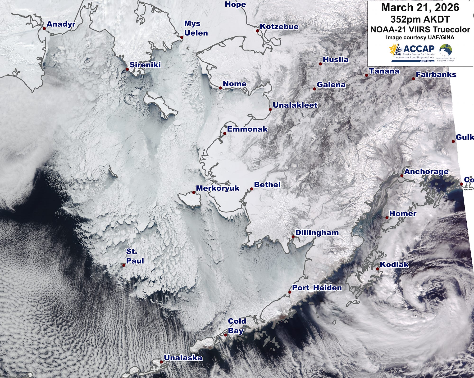
The NOAA-21 truecolor image from March 21 (Fig. 4) is spectacular. Clear skies over most of the eastern Bering Sea, allowed for an unobstructed view of the sea ice extending far southwest on the north side of the Alaska Peninsula, to about the northeast side of Unimak Island, west of Cold Bay. Almost all the ice in the southeast Bering Sea is quite thin: satellite-derived thickness estimates put the open ocean ice thickness at 20cm or less, which will be readily melted by milder temperatures and wave action once the weather changes.
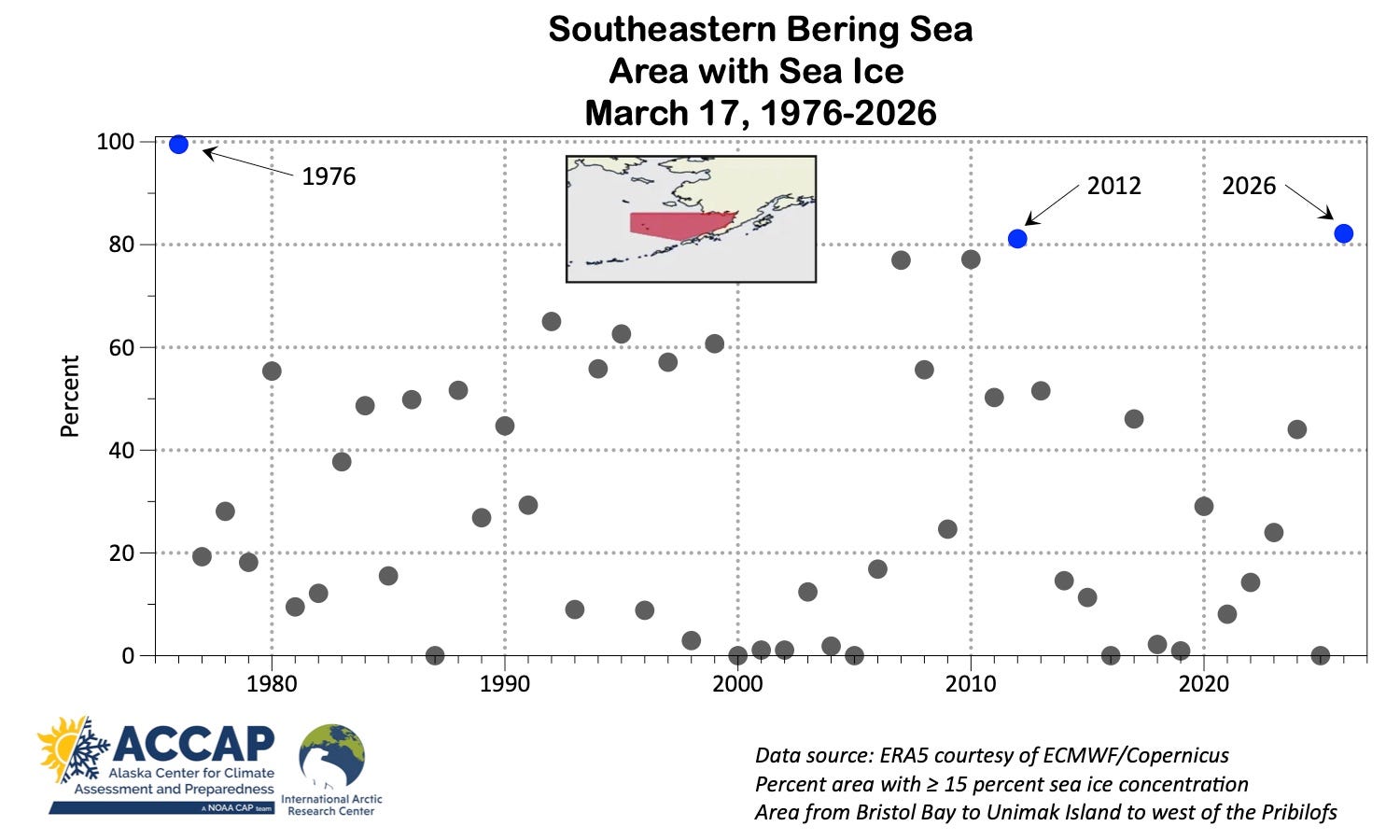
To provide some perspective on how unusual it is to have such ice coverage in southeast Bering Sea, I’ve plotted the percent of the area from Bristol Bay to Unimak Island to just west of the Pribilof Islands (about 270,000 km², shown in the insert in Fig. 5) that had more than 15 percent sea ice concentration on March 17 since 1976 (based on ERA5 reanalysis). Spring 1976 was an extremely high ice spring in the Bering Sea, when effectively all of the area had significant sea ice, with 2012 now 2026 the next highest (2007 and 2010 get an honorable mention). The difference between this spring and 2012 is especially striking given the lack of high ice extent in any spring since then.
Why the persistent cold?
In some ways, the answer is the same as “why the winter cold?”: unusually strong and persistent high pressure aloft over the Bering Sea. But as always, the details matter. During the first half of March, the high aloft was centered quite far west (Fig. 6). This allowed for lower pressure aloft over the Alaska mainland and a sustained push of cold air across western Alaska and the eastern Bering Sea.
 as lines and and departures from the 1991-2020 normal as a color field.")