***Updated November 8 to add the ERA5 temperature and precipitation graphic***
October was an active month weather-wise for Alaska with several high-impact events, so this post has a fair bit of detail. I’ll post the pan-Arctic climate summary once the ERA5 reanalysis for the month becomes available.
Temperatures
Temperatures for October as a whole average close to normal across most of the state with the exceptions of the North Slope, where it was well above the 1991-2020 normal and upper Bristol Bay, where it was significantly cooler than normal.
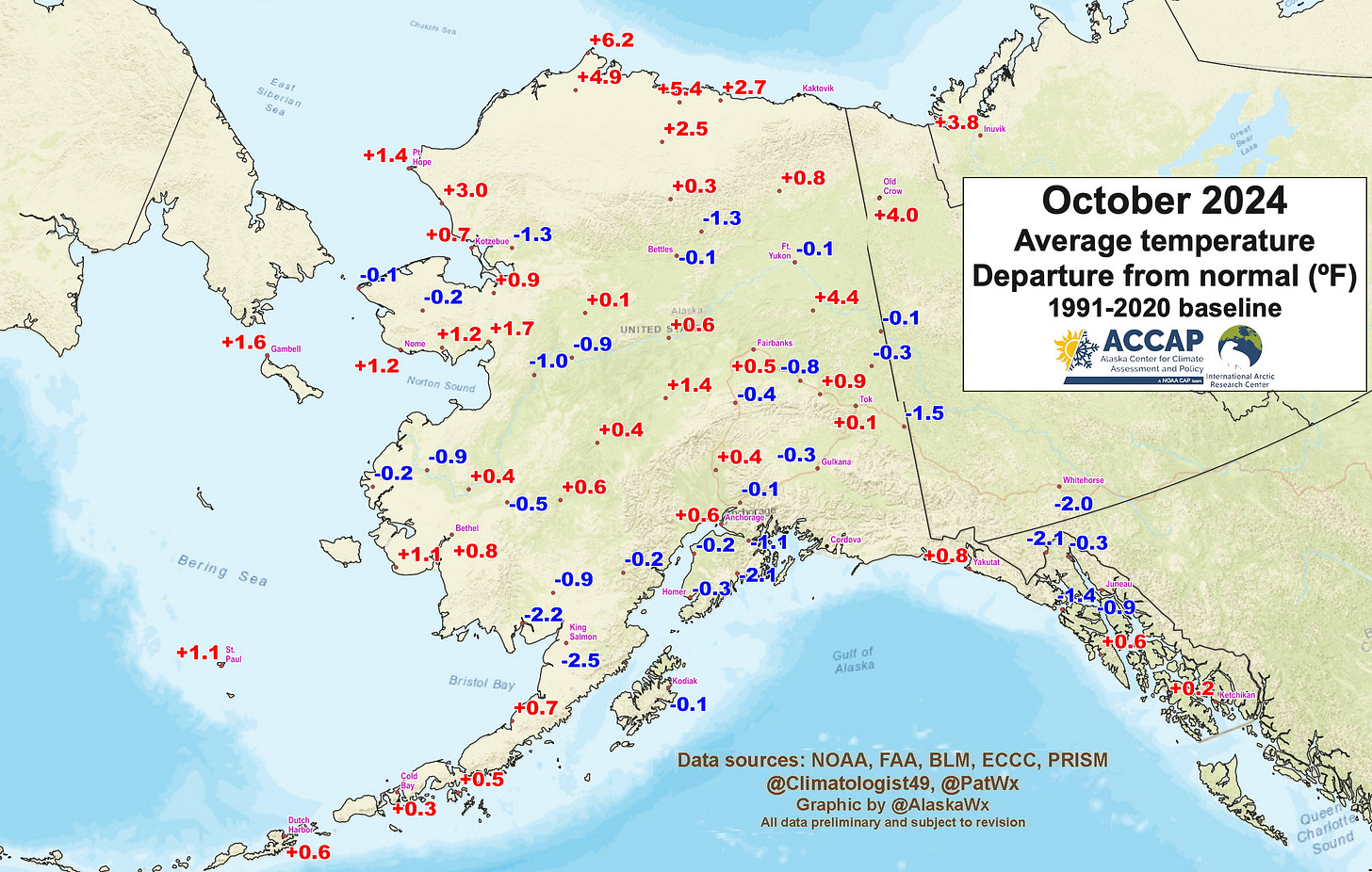
Temperature during the month from reliable observations ranged from 63°F (17.2°C) at Yakutat on the 1st and Adak on 20th to -23°F (-30.6°C) at Umiat on the 31st.

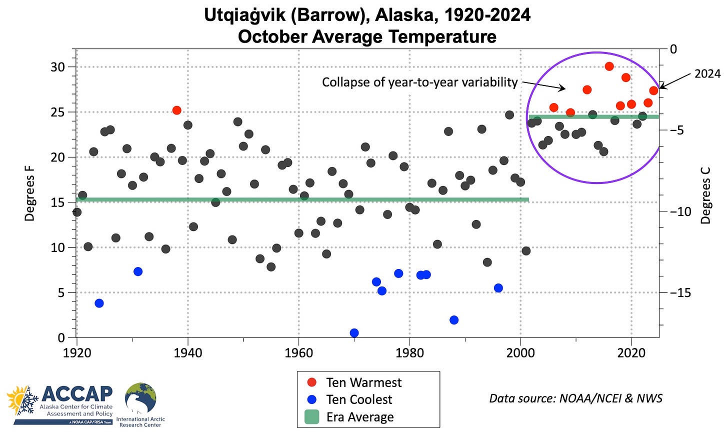
The comparative warmth on the North Slope is no surprise given the open water in the near shore Chukchi and Beaufort Seas. The Utqiaġvik October average temperature time series since 1920 is the most dramatic climate change example I’ve ever seen and illustrates what happens when a major environmental component, in this case sea ice, abruptly changes.
Since 2001, the average October temperature is close to what were the warmest Octobers in the 20th century. Even more remarkable, there are no even moderately cold Octobers any more; the open ocean in all directions except the southeast (land) and minimal solar heating means that temperatures are tightly constrained.
Precipitation
Total precipitation in October was generally unremarkable except for portions of the central and northern Interior, where the monthly totals were 2 to 3 times normal, mostly due to the massive storm of October 20-22. The middle and upper Susitna valley was significantly drier than normal but it was only the lowest October precipitation since 2020.
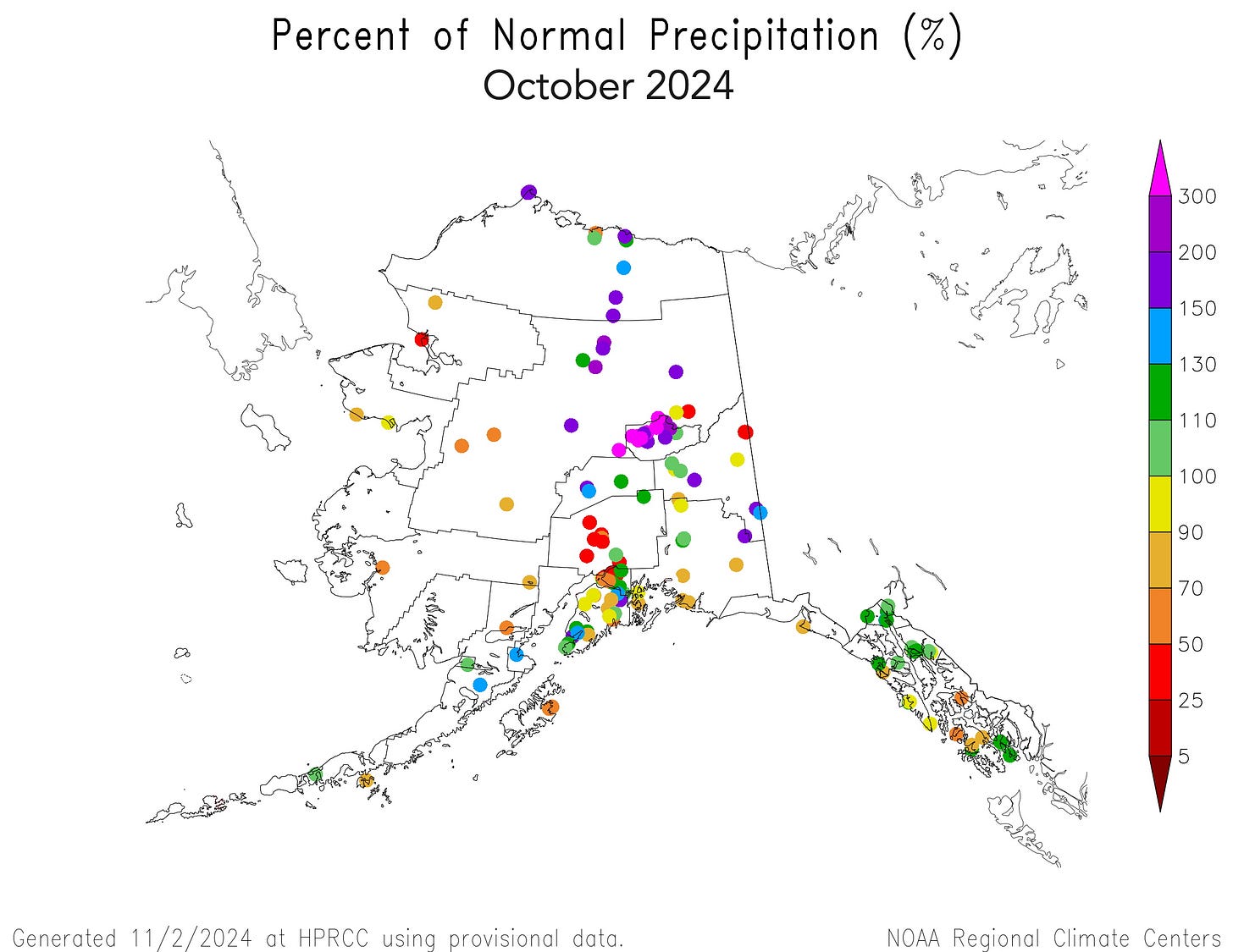
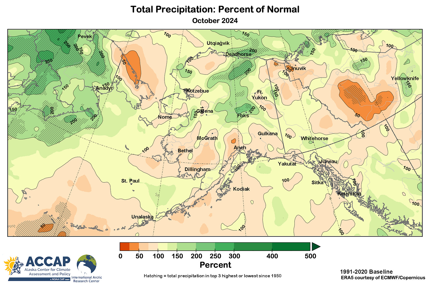
The Fairbanks area and immediately north and west were at the epicenter of the excessive precipitation on the strength of the storm October 20-22. For the month overall, Fairbanks Airport's total of 2.69 inches (68.3mm) was 3.5 times normal and the second highest October precipitation in the past 120 years, with only October 1935 having more. At the Fairbanks Airport, 2.07 inches (53.6mm) in 24-hours on October 20-21 is by far the highest October 24-hour precipitation and by a slight margin, the highest 24-hour precipitation outside of the late summer (July through September) season. Some higher elevation sites reported in excess of three inches (75mm) from the storm. The Keystone Ridge cooperative station (1600 feet, 485 meters MSL) reported 2.77 inches (70.4mm) of rain and melted snow on October 21, the highest calendar day precipitation (any time of year) on record there (since 1996).
Western Alaska flooding
The same storm that brought the excessive precipitation to the central Interior also produced significant coastal flooding in some communities in western and northwest Alaska. At Kotzebue, dozens of homes were inundated, and elders say this was the most extensive flooding in the community in living memory (there are no long term ocean water level measurements at Kotzebue). Severe erosion also occurred at Shishmaref, where the historic cemetery was washed away and there was extensive property damage. On the Bering Sea coast, both Scammon Bay and Nunam Iqua both reported serious coastal flooding, and several communities around Norton Sound, including Kotlik and Unalakleet, saw moderate flooding. There’s a useful news video with selected storm impacts in western Alaska, here.
Snowfall
Snow at the beginning of October was mostly limited to mountain areas of the state, increasing through the month, with most of mainland Alaska having snowpack in place at Halloween, as illustrated in Fig. 5.

While the areal extent of snow cover was typical in October, snowfall amounts in some areas were quite high. Reminder: across mainland Alaska there are hardly any daily snowfall observations at places not on the connected road system.
Snowfall during the October 20-22 storm in the Fairbanks area was strongly elevation dependent. In the hills north and west of town, thousands of customers lost electrical power, some for more than four days, due to rain-soaked snow clinging to trees and bending into power lines. Snowfall used for the official Fairbanks total nowadays is measured at the University of Alaska Fairbanks on Troth Yeddha’ (West Ridge), about 200 feet higher elevation than the Airport. So while officially the 18.4 inches of snow in October was the ninth highest snowfall total, adjusting for the elevation difference between the Airport (where snow was measured for more than 60 years) and the current observation site, this was likely closer to 20th highest total. The Keystone Ridge cooperative site at 1600 feet, 485 meters elevations reported 31.7 inches (80.6cm) of snow, the most in any October on record (since 1996).
In Southcentral, two snow storms during the last days of the month brought high accumulations to parts of the region. The first storm commenced during the morning of October 28 and continued for about 24 hours. The highest accumulations were in the Kenai/Soldotna area northward into west Anchorage, with the NWS office at Sand Lake reporting 11.5 inches of snow, and 10-13 inches was reported in the Soldotna area. Snowfall amounts from this storm were lower on the Anchorage Hillside and north to the Eagle River area and in the Palmer and Wasilla areas. The second storm began early on Halloween and continued through the evening. Snowfall amounts of 5 to 8 inches in the Kenai/Soldotna area and 6-11 inches in the Anchorage area. Once again, totals were significantly lower in the Eagle River area, but the Wasilla and Willow areas had higher snow totals than the October 28-29 storm. In total, the Anchorage Airport monthly snowfall totaled 21.5 inches (54.6cm), the fifth highest October snowfall since 1953.
Not to be outdone, there was notable snow in northern Southeast Alaska. Juneau Airport saw 1.7 inches (4.3cm) of snow October 18-19, which tied for 5th earliest occurrence of 1 inch or more since 1943. At Haines, the same storm produced 19.3 inches (49.0 cm) of snow, the highest snowfall so early in the season since 1974.
Sea surface temperatures
Ocean surface temperatures for October were above normal offshore of all of the North Slope, while the southern Chukchi Sea was closer to normal in Alaska waters. The Bering Sea was near to below normal except for the Gulf of Anadyr. Very warm water (relative to normal) was found on the Pacific side of the western Aleutians. Gulf of Alaska sea surface temperatures were overall close to normal.
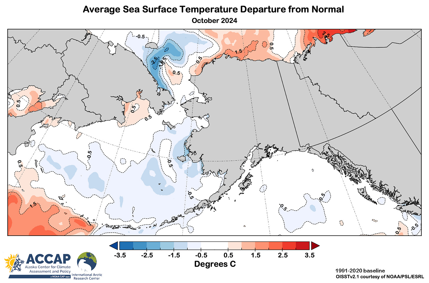



Continued non-uniform surface sea temperature rise (except in the Chukchi this year.) As goes the sea, the land follows eventually one must suppose.