


Alaska May 2025 Climate Summary
Mostly cool and wet

Following a mild April in most areas, May was generally cooler than normal in Alaska. But like April, many places saw well above normal precipitation. Of course, there were significant regional exceptions.
Temperatures
May temperatures around Alaska were overall, near to a bit cooler than normal. The exceptions were portions of western Alaska that were a little bit warmer than normal, while portions of the Brooks Range and North Slope had the coolest May in more than decade. The site-specific departures are shown in Fig. 1a and the ERA5 reanalysis departures are shown in Fig. 1b.
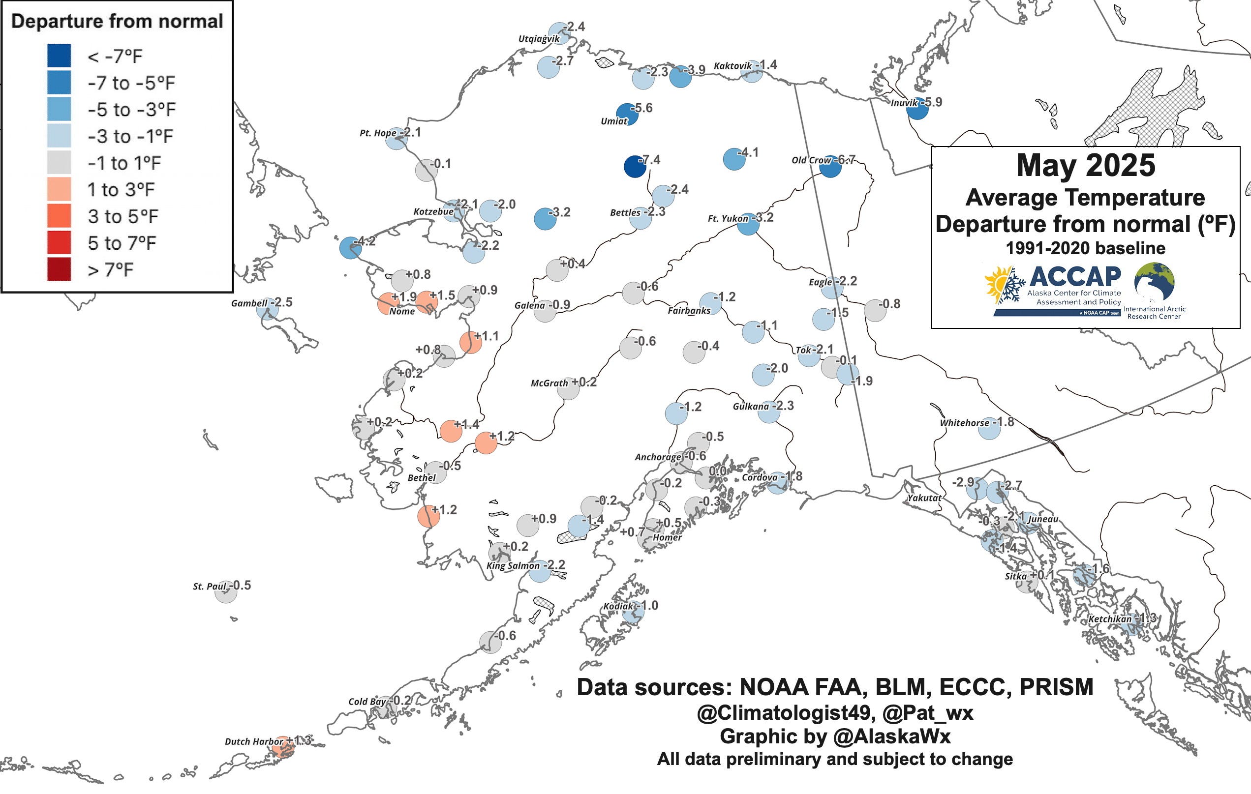
Based on the ERA5 reanalysis, this was the coolest May since 2013 for the North Slope Borough, the upper Yukon Valley (greater Ft. Yukon area) and Fairbanks North Star Borough (although 2013 was much cooler in all these regions).

Possibly the most unusual aspect of May temperatures was the complete lack of warm weather anywhere in the state. Figure 2 shows site-specific high temperature during the month. Fairbanks failed to reach 70F (21.1C) for the first time in May since 2001 and Utqiaġvik failed to get above freezing for the first time in May since 2007. At Deadhorse, the state airport for the Prudhoe Bay oil fields, this was the first May without the temperature getting above freezing since climate observations began in late 1968.
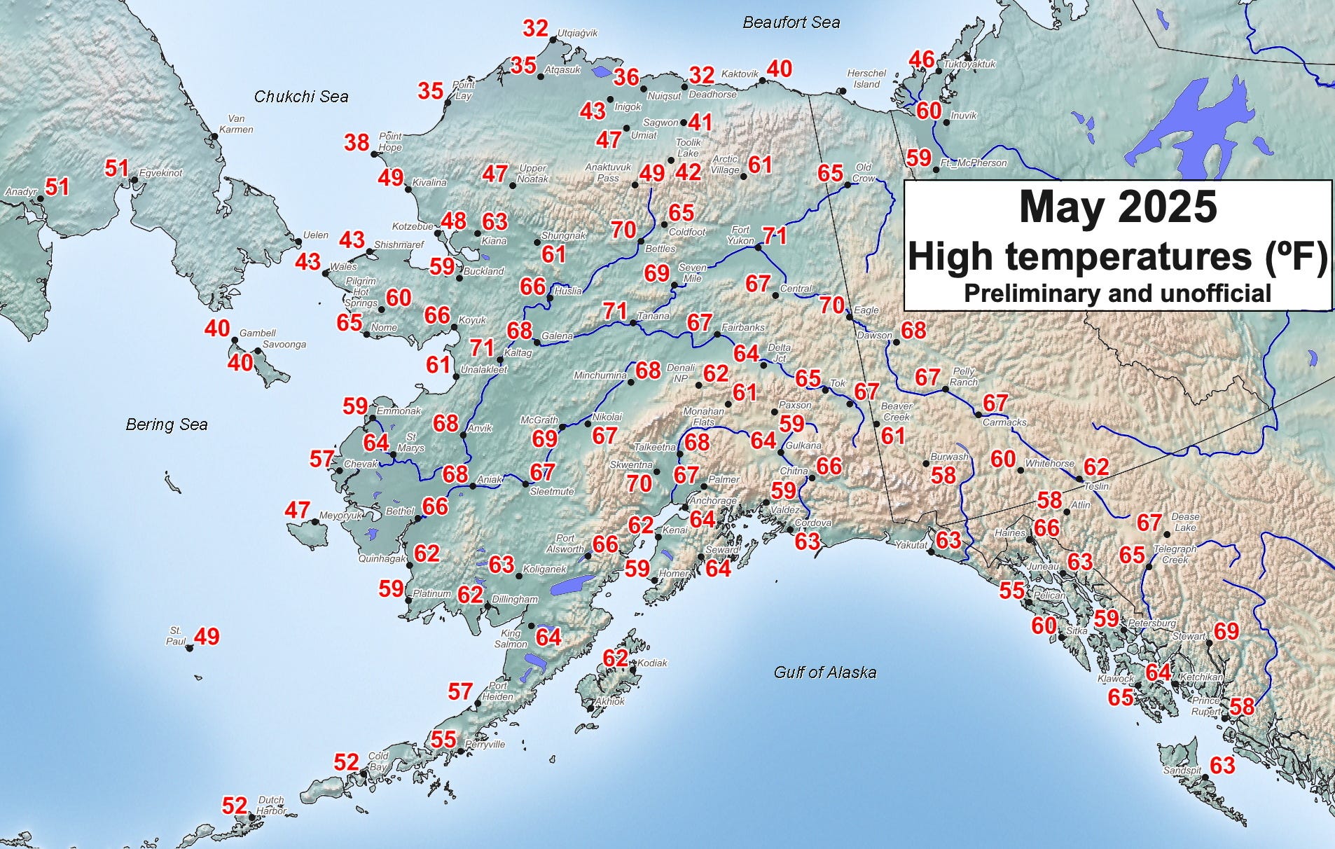
The highest reliable temperature reported in Alaska during the month was 71F (21.6C) at a number of locations, including Ft. Yukon, Tanana and Kaltag in the Interior and the Amber Lake cooperative site in Southcentral (southwest of Talkeetna). While direct comparisons are difficult because of varying station availability, this appears to be the lowest statewide high temperature since 1971, when no place in the state reached 70F (21.1C) in May. In May 1911, the highest reported temperature was 70F but there were of course very few climate stations active in Alaska at that time. The statewide low temperature in May was -8F (-22.2C) on May 1 at the Toolik Lake 5ENE CRN station in the Brooks Range, which is not unusually low.
Precipitation
The big story for May was the excessive rainfall over parts of the state, but especially in Southeast Alaska, where many places had 2 to 4 times normal. Site-specific percent of normal precipitation is shown in Fig. 2a and the ERA5 reanalysis is shown in Fig. 2b.
The long term climate sites in southern Southeast all set May records. Totals included 37.81 inches (960.4mm) at Little Port Walter, 25.58 inches (649.7mm) at Ketchikan Airport, 19.83 inches (503.7mm) at the Metlakatla 6S CRN and 18.38 inches (466.9mm) at Petersburg.
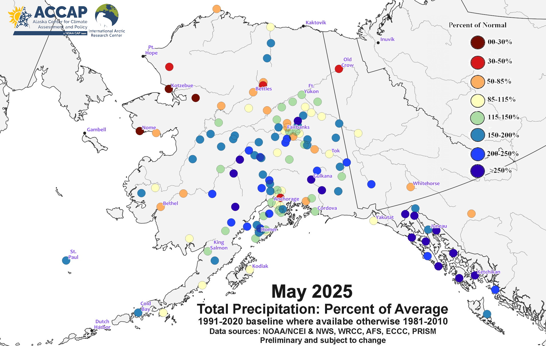

At Juneau airport, total precipitation in May of 6.46 inches (164.1mm) was the fourth highest of record (and both 2021 and 2024 had more) but measurable rain (0.01 inches or more) fell on 30 days. That’s happened only a few times in October and once in December. While absolute rainfall totals were much lower, relative to normal some inland areas in Alaska were also very wet in May. At Gulkana (Copper River Valley), 2.17 inches precipitation was nearly three times normal and the third highest on record: the only wetter Mays were 2023 and 2024.
In dramatic contrast, western Alaska from the Yukon delta north to the western North Slope had well below normal precipitation in May. For Northwest Arctic Borough (the Kotzebue region), this was the lowest precipitation May since 2007, with some areas having less than one-quarter of normal May precipitation.
Snowfall was not much of a factor in May. The UAF Research Station at Toolik Lake (elevation 2400 feet MSL) in the Brooks Range reported 7.4 inches (18.8cm) of snow through the CoCoRaHS network and this was the highest May snowfall reported from the comparatively few sites that actually report daily snow in the state. There were a couple of days with accumulating snow in the Copper River Basin, and the 2.7 inches (6.9cm) at the Glennallen cooperative station was the highest May total since 2013.
Sunshine (or lack thereof)
As you might expect, with all the rain came a real lack of sunshine. Figure 3 shows the rank of May 2025 solar energy received at the ground compared to all Mays since 1979 (when satellite data began to be incorporated into the ERA5 reanalysis). Relative to the past 47 years, Southeast Alaska was especially gloomy, but portions of southwest Alaska also had one of the lowest sunshine Mays in recent decades. Most of the northern quarter of the state had more sunshine than is typical in May.

Sea ice and sea surface temperatures
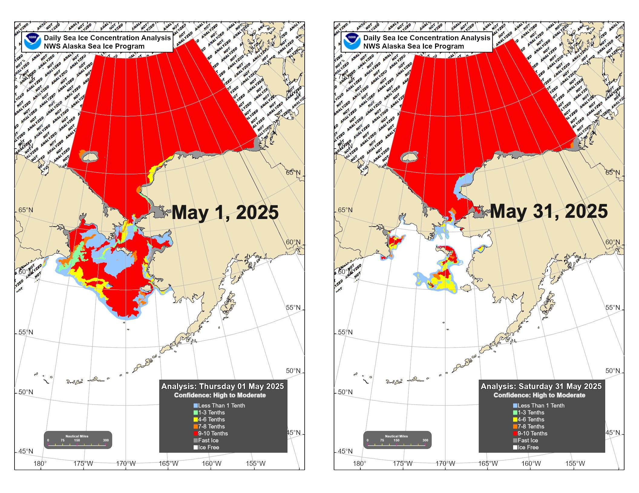
The daily sea ice concentration analysis from the National Weather Service Alaska Region for the start and end of May are shown in Fig. 3. At the start of month, the large areas of open water in the northern Bering but with high concentration farther south was unusual, and the ice reached St. Paul Island for a few days the first week of the month. In the Chukchi Sea, open water was slow to expand, though the lead off the southwest North Slope coast at times was 100 miles wide. At the end of May, the open water area in Chukchi Sea was the lowest since 1999 in the National Snow and Ice Data Center Sea Ice Index.
May average sea surface temperatures (SSTs) in non-ice influenced areas in the Bering Sea and Gulf of Alaska were generally near to above normal, and Bristol Bay SSTs were the highest for May since 2019. The below normal SSTs in the Chukchi Sea reflect the continuing presence of ice through the month.
