
Alaska December 2025 Temperature Summary
Coldest December in decades

December 2025 was a month of weather and climate extremes in Alaska. I’ve written about the four-day wind storm in the Mat-Su valley here, the cold snap through Christmas here, and the historic Southeast Alaska snowfall here. This post focuses on the (continuing) long duration cold snap as reflected in the complete December data. I’ll have an explanation of “why” in the upcoming December 2025 Arctic summary.
Monthly average temperatures
December was the coldest month since January 2012 over most of the central and eastern Interior and the coldest December since 1980. The lowest average temperatures occurred in the Alaska-Yukon borderlands and on the Yukon Flats, though were still quite low as far west as middle Yukon and Koyukuk River valleys.
In Southcentral and southwest Alaska this was generally the coldest December since 2010 but the coldest month only since January 2020 (or in some cases January 2024).
Prior to the extreme snowfall it was quite cold over Southeast, and Juneau Airport finished up with the coldest December since 1964 and the coldest month since January 1996. Farther south though it was not nearly as extreme, with this being the coldest December only since 2021 at Sitka, Petersburg and and Ketchikan.
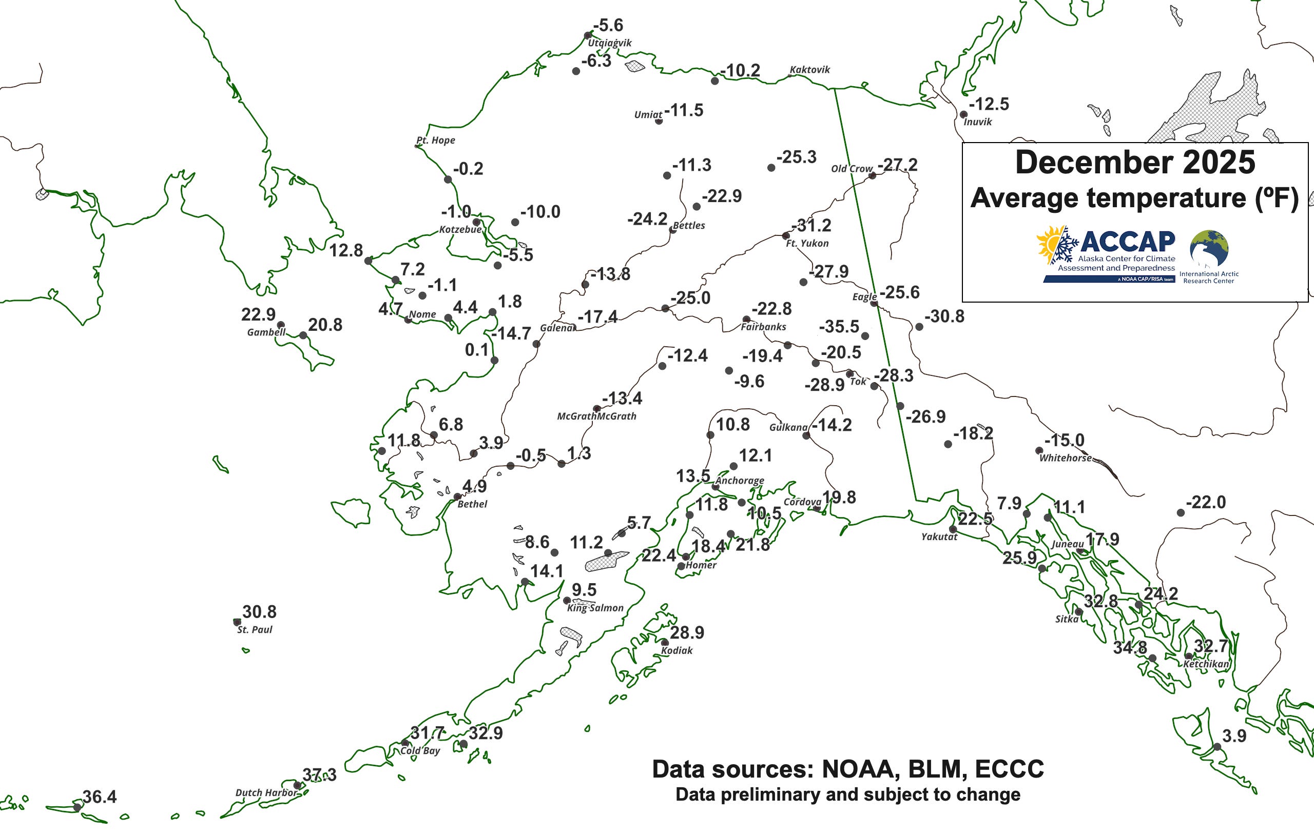
At this scale it’s not possible to depict the large variation in temperatures that occur in short distances during the winter months in many parts of northwest North America. For Fig. 1, where there are multiple places with reliable observations, I plot either the official climate site, e.g. Anchorage, Fairbanks and Utqiaġvik, or the long-term climate site from cooperative observers, e.g. Tok, Denali National Park Headquarters and Eagle.
In Southcentral, December had considerable low-elevation temperature variability due to the proximity to Cook Inlet and the local frequency of significant wind, e.g in the Anchorage area, monthly average temperatures ranged from 13.5°F at Anchorage International Airport to 5.8°F at Ft. Richardson in northeast Anchorage. In the Interior, mid-winter average temperatures are always strongly modulated by elevation and this month was no exception. In the Fairbanks area, December average temperatures ranged from -23.7°F at North Pole to -8.7°F at Keystone Ridge, northwest of town at 1600 ft MSL. Wind is also locally a factor in the Interior, e.g. the Delta Junction area, where the Clearwater Lake area is often calmer and much colder than areas closer to the Delta River.
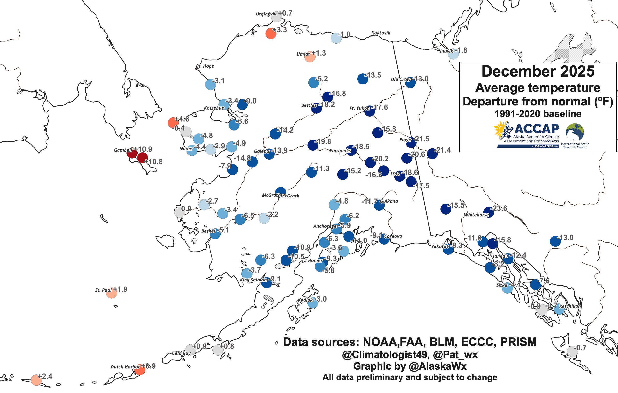
Average temperatures for the month were lower than the 1991-2020 normal over most of Alaska and northwest Canada, with some sites 20°F or more below normal (Fig. 2). The exceptions were the North Slope, the lower Alaska Peninsula and Aleutians/Pribilof Islands and and the Bering Sea coast west of about 165°W. St. Lawrence Island in the northern Bering Sea was especially mild.
December 2025 low temperatures
The minimum temperatures reported during the month were low, though a very pronounced west-to-east gradient is obvious (Fig. 3). The eastern Interior and Yukon Territory are areas that historically temperatures reached extremely low levels (the North American record low temperature of -81F was recorded at Snag, YT, near present day Beaver Creek), so it’s unsurprising that mid-winter temperatures in the 50s or even 60s below are not records. Tok’s December low of -58F on the 23rd tied the daily record previous set in 2012, while Northway’s monthly low of -57F on December 22 tied the daily record first set in 1961 and tied in 1971. There were probably a few daily record set in the Yukon, though I don’t have ready access to daily record temperature information.
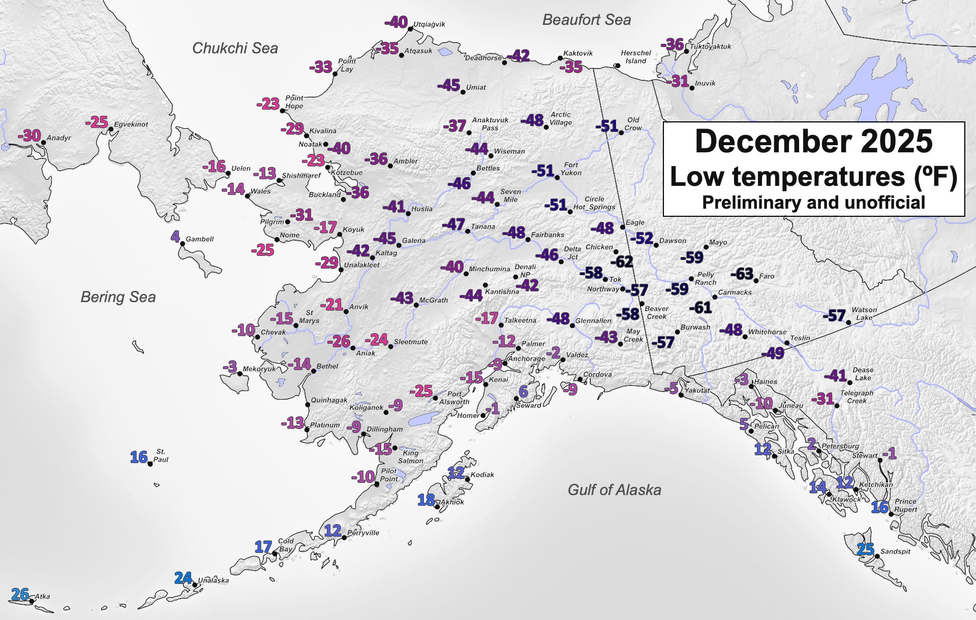
For reference, all-time December record low temperatures include:
Fairbanks airport -62F in 1961 & Eagle -69F in 1961
Tok: -70F in 1964 & Northway: -64F in 1956
Chicken: -72F in 1999 (observations only since 1996) and Ft. Yukon -71F in 1935
Dawson: (at least) -66F in 1961 & Whitehorse: (at least) -54F in 1942
The duration of cold is reflected in these December statistics:
Fairbanks Airport: 12 days with lows in the 40s below (all after Dec 14) and there were 22 hours with dense ice fog (visibility one-quarter mile or lower)
Tok: 12 days with lows in the 50s below
Dawson, YT: 19 straight days with lows -40F/C or lower
The “consecutive days” streaks I mentioned in my previous post are still in play:
Fairbanks airport: daily low temperature -15F or lower every since December 4. Record is 38 days (thru January 3rd at 31 days).
Another Fairbanks airport streak to keep an eye on: daily high temperature 0F or lower everyday since December 14. Record is 30 days (through January 3rd at 21 days). The Ag Experiment Farm record is 40 days from 1917-18 and that is likely safe.
Tanana: daily low temperature -10F or lower every day since December 3. The record of 53 days is likely safe but could be a “top 5” longest (through January 3rd at 32 days).
Eagle (cooperative): daily high temperature below 0F every day since December 5. Record is 40 days (through January 3rd at 30 days).
I’ll never forget January 1989. My due date was January 26 and it was -68 at my house. Luckily my son arrived in February. 😊
The winter of 1989 stands out in my mind - flights cancelled due to high barometric pressure, broken fan belts littering the streets causing cars to overheat. It was a challenging and dangerous time. Where does that winter fit in? Thanks!