This post is the Alaska-focused August climate summary. Once the ERA5 reanalysis is available (and I get back from some work travel), I’ll have the Arctic review for August and a summer 2023 review.
Temperatures
August was a mild month over much of Alaska, but especially over the Interior and North Slope, with average temperature departures from the 1991-2020 average shown in Fig. 1. For a few long term climate sites in the extreme eastern Interior, this was the warmest August on record, most notably Northway, where the August average temperature was 60.3F (15.7C), easily exceeding the previous record warm August of 1994. The average temperature for August at Fairbanks Airport ranked as the third warmest, but the average daily low temperature of 52.8F (11.6C) is the highest daily minimum for August, and the low for the month of 45F (7.2C) is the highest August low temperature on record. While Southcentral and southwest/western Alaska were not as far above normal as areas to the north and east, this was still a substantial change from June and July, when many places were cooler than average. Some places in these parts of Alaska saw the highest temperatures of the summer occur in the first half of August, including 79F (26.1C) at King Salmon, 74F (23.3C) at Nome and 73F (22.8C) at Anchorage Airport.

Preliminary weather station temperature extremes for the month are a statewide high temperature of 92F (33.3C) on the 5th at Robertson River (Tanana Valley west of Tok) and a low of 26F (-3.3C) on the 23rd at the Climate Reference Network Station near Red Dog Mine north of Kotzebue.
Precipitation
August rainfall overall followed the pattern of much of the summer. Figure 2 shows the August total rainfall as a percent of normal. Southcentral was again wetter than average, as was much of southwest Alaska and the western Interior and west coast, while portions of the eastern Interior were unusually dry. However, in the Interior, unusually late season thunderstorms brought heavy downpours to some places while others missed out, hence the variable totals relative to normal over short distances, e.g. the Fairbanks area and southeast Interior.
For the second year in a row, August rainfall was heavy in the Prince William Sound and Kenai Peninsula areas. Valdez reported more than 13 inches of rain, nearly twice normal, while the Mt Eyak SNOTel station near Cordova, at 1400 feet, 425 meters MSL, received just over 30 inches (770mm) of rain. Excessive rainfall was widespread enough in the Susitna River valley to cause some flooding late in the month on small creaks as well as the Yentna and Susitna River proper.

Rainfall departures in Southeast Alaska were more mixed than in July but overall most places were not too far from normal. One extreme though occurred on August 12, when the Sitka Airport reported 4.42 inches (112.3mm) of rain, the highest August calendar total on record.
Thunderstorms
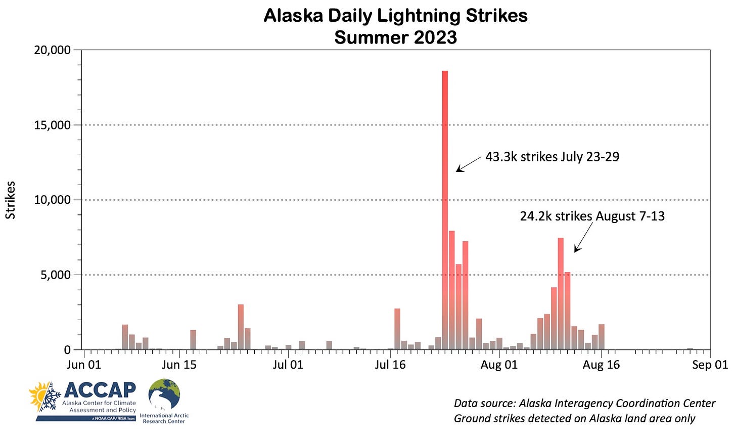
As we discussed previously in this post, there was an unusual lack of thunderstorm activity in Alaska early in the summer and then the dramatic burst July 24-25, which was the most lightning in one day in Alaska since July 2019. The second week of August also brought a rare late season thundery period While not extreme by June or July standards, this appears to be the most lightning this late in the season in more than 35 years, even accounting for the change in lightning detections systems in 2012. The collapse of lightning after August 16 seen in Fig. 3 is the result of the climatologically late onset of increase westerly winds aloft and resulting more stable airmass over mainland Alaska.


