

September Snow in Alaska
September Snow in Alaska
Uncommon but impactful

September 19 note: I expected to be posting about the 2024 Arctic sea ice minimum about now, but there’s an ongoing data processing problem at the National Snow and Ice Data Center. So while we wait, something a little different.
September Snow
During the summer, accumulating snow in Alaska is typically confined to the high mountains and to the North Slope, though on rare occasions early June can bring low elevation snowfall, especially north and west of the Alaska Range and in the Copper River basin.
As September progresses snow levels typically lower and snowfall at lower elevations from the Alaska Range northward becomes less unusual. In the past three decades there have been several Septembers that had quite a bit of snow in the Interior, some with high impacts, principally from downed trees and power outages. This in turn has prompted the question: is September snowfall increasing, or at least, are high September snowfalls becoming more common? This is not an easy question to answer because few places in Alaska have reliable, multi-decade, nearly complete snowfall data, and of course only some of these are in the Interior.
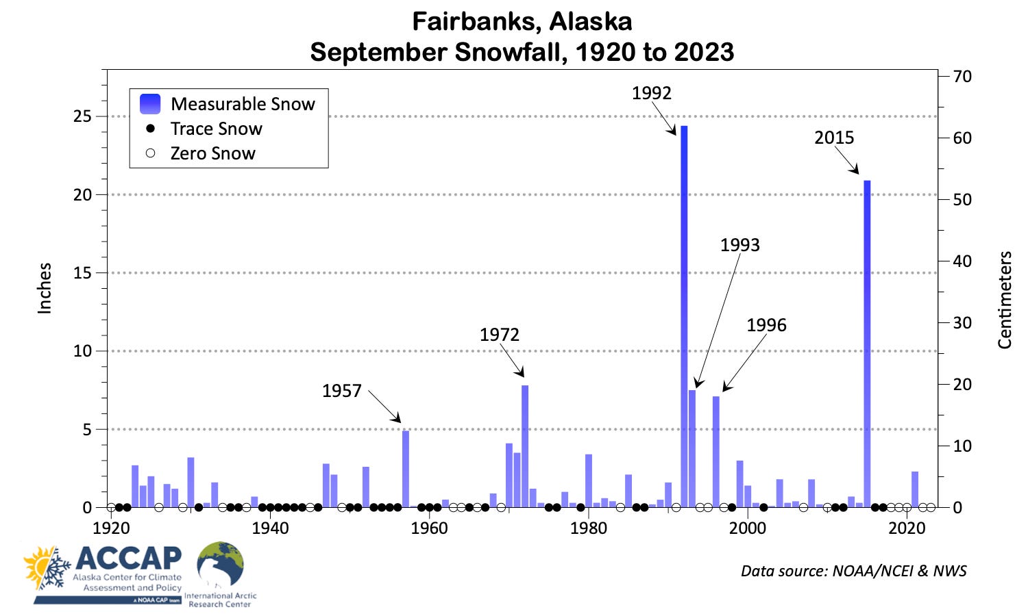
But here’s what we have. Figure 1 plots the September snowfall at Fairbanks (elevation about 450 feet, 135 meters) since 1920.1 The snows of 1992 and 2015 stand out for the high amounts and four of the five highest September snow totals have occurred since 1992. However, it’s important to note that most September have little or no snow: since 1920, 55 percent of Septembers have had either zero or trace (not measurable) snowfall, and three quarters of Septembers have less than one inch of snow.
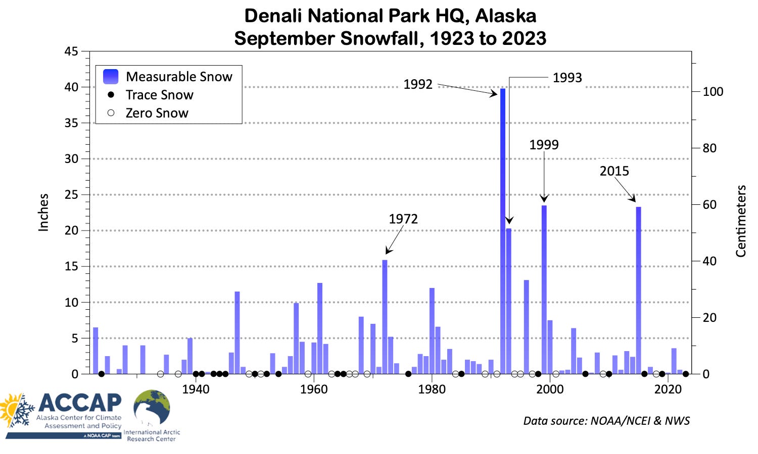
Climate observations have been made for more than 100 years at Denali National Park (Headquarters area, elevation about 2100 ft, 630 meters MSL), and fig. 2 shows a similar pattern to Fairbanks: four of the five highest September snowfalls have been since 1992, though not all the same years. Because the Denali National Park climate station is at significantly higher elevation than Fairbanks, there are fewer Septembers without measurable snow: 37 percent have zero or trace totals, and this total is likely higher than would be the case if there were round-the-clock weather observations.2
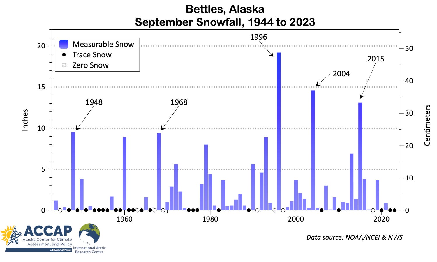
Looking to the northern Interior, Bettles (66.9°, elevation 640 feet, 190 meter MSL), fig. 3, shows a slightly different picture. Not unexpectedly, September more often than not has measurable snow, and a few inches accumulation is not uncommon. It’s very likely just a fluke of the handful heavy snow producing weather patterns in recent years that the highest September snowfalls at Bettles were lower than Fairbanks or Denali: Bettles is a fairly snowy place for low elevation Interior Alaska and annually averages more than 35 percent higher snowfall than Fairbanks. Although there’s a shorter period of record at Bettles than Fairbanks or Denali, two of the five highest September snowfalls occurred prior to 1970.
Is September Snowfall Changing?
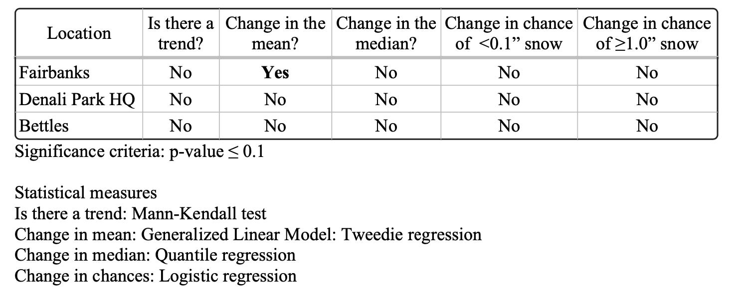
This should be a simple question right? Wrong. Like many climate parameters, snowfall has a natural lower bound: there can’t be less than zero snow. Because September snowfalls of zero are common, but occasionally are large, commonly used statistical analysis tools, like ordinary linear regression, are not appropriate. Table 1 lists a variety of methods I looked to evaluate possible changes in September snowfall at the three climate sites shown in Figs 1-3. As you can see, nearly all of the tests are negative in the statistical sense, i.e. there isn’t robust evidence for systematic change (up or down). The one exception was for change in the average snowfall at Fairbanks, which was statistically significant.
Overall, this analysis suggests that the big September snows at these three climate stations are not indicative of longer term trends but more likely the result of the typical random variability in the climate system which, when all the pieces come together, can produce heavy snow very early in the cold season.
September Snowfall Impacts
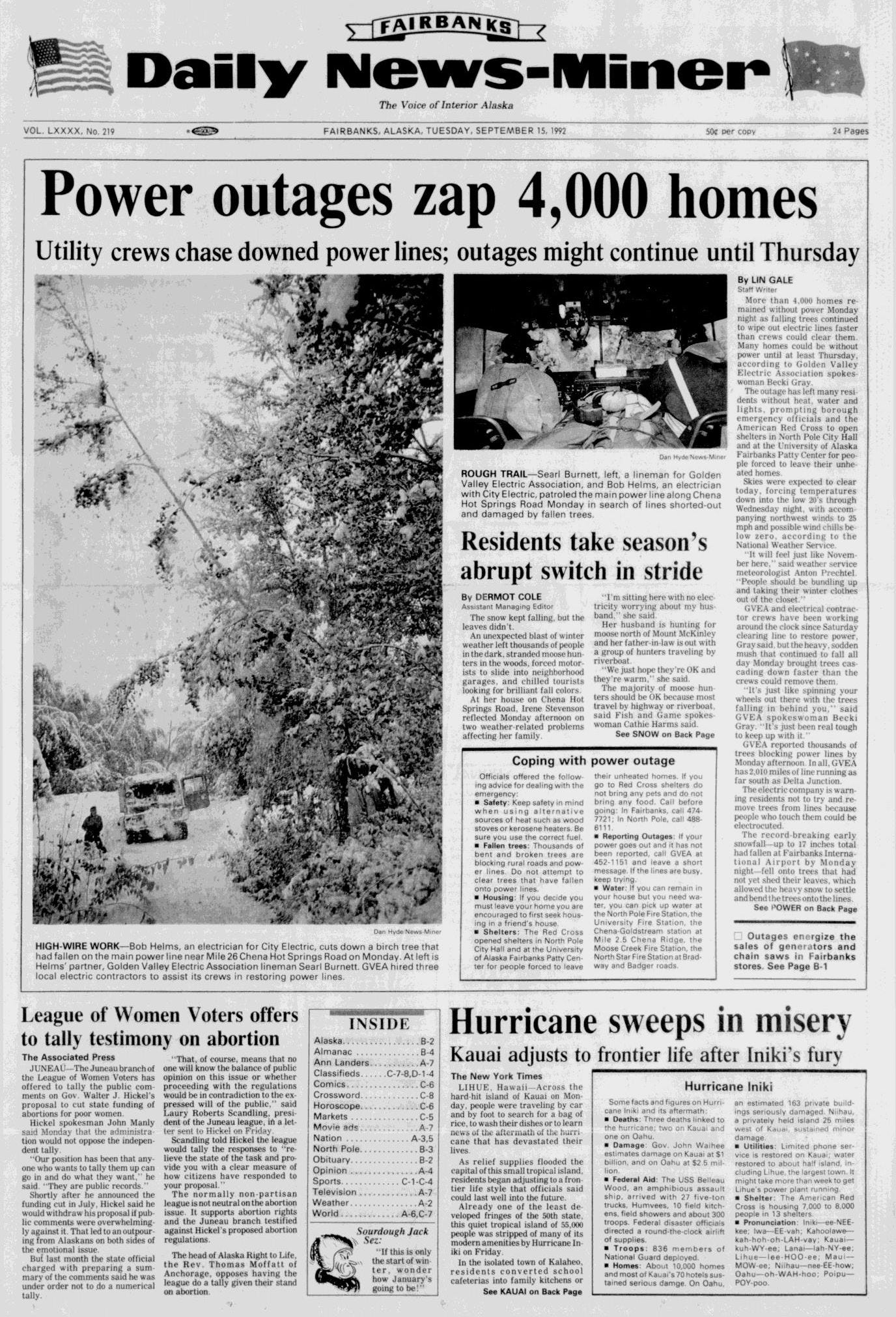
Heavy snow in Interior Alaska in September is almost always heavy wet variety, unlike most high snowfall during the winter and early Spring, which have much higher snow-to-liquid ratios. While heavy September produce difficult driving conditions, the bigger impacts have historically been downed trees and powerlines. Much of the September 1992 snow occurred around mid-month, when many trees still were in full leaf. The headline from the Fairbanks-Daily News Miner from September 15, 1992 tells part of the tale. It turned out that the headline was optimistic: in some areas it was more than a week before power was restored, and evidence of severely bent over birch and aspen trees can still be seen today.
The September 2015 heavy snow occurred late in the month and trees were largely bare, but there were still many downed trees and multi-day power outages.
Fairbanks climate observations start in September 1904 but the snowfall observations are inconsistent or just missing through 1919, though there’s nothing to suggest that there were any big September snows during these 16 years.
Most WB/NWS cooperative stations historically under-reported trace amounts of snow (and rain) relative to 24-hour per day WB/NWS/FAA airport stations, usually due to confusion over what should be reported: many observers apparently thought if snow didn’t accumulate, or accumulated but melted before the scheduled observation time, it didn’t count. There are examples of this in the Denali National Park climate record. And of course flurries or mixed rain and snow that occur in the middle of the night and don’t accumulate at all may go entirely unnoticed.
Is there a statistically significant September precip increase in all interior stations? How big is that? It seems like recent pre-ground-freeze-up rains are saturating the surface layers (garden soil or dirt roads) circa September.
Very interesting.
I find myself curious about the October-through-Christmas snow patterns, especially in Fairbanks. It "seems" (i.e. purely subjective, anecdotal) to me like the snow we get in that period has been warmer/wetter (and sometimes ice rather than snow). It "seems" like in older days, you could get a good snowfall in early October and that was it for 6-7 months. Good, solid snowpack coupled with low daytime sun made for a winter wonderland. It "seems" like in more recent years I'm struggling more frequently with clearing heavy wet snow (or "mashed potato snow" as Eric Stevens used to call it) that sort of bonds with the yet-to-be-frozen gravel driveway, making for a royal mess. Seems like this happens even in early December in recent years. And, of course, who can forget the miserable wet snow / rain dump of Christmas 2021. It "seems" like the good kind of winter may not really settle in until after the solstice.